Pricing Change
New pricing for orders of material from this site will come into place shortly. Charges for supply of digital images, digitisation on demand, prints and licensing will be altered.
Scheduled Maintenance Notice
Please be advised that this website will undergo scheduled maintenance starting on Thursday, 30th January at 11:00 AM and will last until Friday, 31st January at 10:00 AM.
During this time, the site and certain functions may be partially or fully unavailable. We apologise for any inconvenience this may cause.
Field Visit
Date April 2010
Event ID 625217
Category Recording
Type Field Visit
Permalink http://canmore.org.uk/event/625217
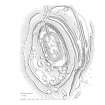
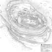
Castle Law is situated on the northern escarpment of the Ochil Hills overlooking Strathearn, and at 280m OD, towers 200m above the valley below, commanding a panoramic view northwards from the NW round to the ENE. The outlook in other directions is less spectacular and the site is overlooked by Culteuchar Hill immediately to the SW. The fort is depicted on the 1st edition of the Ordnance Survey 6-inch-to-a-mile map (Perthshire 1866, sheets CIX & CX) and was mentioned in passing by Christian Maclagan in her volume The Hillforts, Stone Circles and other Structural Remains of Ancient Scotland (1875). In 1892 the fort was subject of an excavation by Edwin Weston Bell, a member of a merchant family and resident of Dundee who bred dogs at nearby Rossie.
Detailed survey of the fort has identified several phases of enclosure punctuated by at least one major period of open settlement, and the final occupation of the hill in prehistory is probably represented by the smaller of the two timber-laced forts on the summit. The excavations by Bell did not recover any diagnostic artefacts and none of the meagre assemblage that he recovered (now in the Royal Museum of Scotland) has a secure context that provides useful dating evidence. Confirmation of the use of the hill in more recent times is restricted to a possible building occupying the interior of a hut-circle on the SE flank of the fort and a degraded bank that overrides rampart 20m upslope from it. Bell also discovered sherds of glazed pottery.
Bell’s account makes it very clear that prior to the excavation the earthworks enclosing the summit of the hill were not particularly prominent. Indeed, he had to guess at the location of the entrance, which he subsequently cleared out, resulting in the large heap of spoil that is now plainly visible below the modern track that approaches from the E. Nevertheless, the excavation succeeded in demonstrating the presence of two separate timber-laced walls, at least one of which, probably the outer, contained the vitrified material that can be found in the scree below, particularly on the S. Bell also discovered two rock-cut post-holes, which appear to represent a period of construction that is earlier than the inner of the two timber-laced walls. Once he had cleared the entrance, the excavation strategy appears to have been to define the inner and outer faces of the two timber-laced walls on the summit, dig trenches and smaller pits in the interior, and test-trench the entrance through a lower line of enclosure on the NW.
The survey of the fort has identified at least four phases of construction. The earliest seems to be a large enclosure which took in the summit and some of the broad lower terrace on the S, where it is defined by a thick rampart and an external ditch. On the W, this line of defence can be seen climbing obliquely up the slope to disappear under a later rampart, while the northern part of this circuit is entirely lost beneath the outer and earlier of the timber-laced walls. The topographical position of the area enclosed, taking in a steep S-facing slope, is unusual and it is possible that these defences represent the outworks of a summit enclosure that is no longer visible, rather than a freestanding fort.
In a subsequent phase the first timber-laced wall was constructed along the line of the natural crest of the summit. Oval on plan, it measures 102m from WNW to ESE by 50m transversely within a wall 4.9m in thickness. This wall has been heavily robbed, but where he dug out the entrance on the E Bell found it standing up to 1.4m high, and it was up to 1.5m high on the SW. The smaller timber-laced fort (59m WNW to ESE by 24m) occupying its interior is certainly later in date and probably represents the last phase of enclosure on the hill. The earlier timber-laced wall, however, had probably been robbed already to construct the rampart of another large enclosure (measuring 42m WNW to ESE by up to 82m) that can be seen extending along the edge of a terrace to the N of the summit and surmounting the ruinous timber-laced wall on the SW. What may be a coeval outer rampart is visible on the W and NW, its line carried by a ragged scarp along the steep N flank of the hill to link with another short length on the E. Both of these ramparts are broken on the NW by an entrance through which a hollowed track-way passes. The terminals of both ramparts here have been flattened to form well-defined platforms for later timber round-houses.
Although Bell did not find a break in the wall of the small timber-laced fort built on the summit, the earlier entrance on the E was almost certainly retained, extending up the slope beside a thick wall that now appears to link the two timber-laced walls. The relationship of this wall to either is unknown and Bell’s trenches appear to trace its line at least 11m into the interior. He conjectured that the entrance may have been set above the level at which he found the innermost wall surviving.
Two other elements of the visible defences do not fit easily into any of these four phases. One is the broad ditch and its external rampart at the foot of the steep S face of the hill. The rampart, now reduced to a thick bank, appears to overlie the rear of several timber house platforms that are cut into the back of the phase 1 rampart immediately to the S, thus indicating a comparatively late date for its construction, possibly as an outwork of the latest timber-laced fort. The second element is the bank that extends along the leading edge of terrace outside this same sector of the phase 1 rampart. Possibly this has formed part of an enclosure taking in a source of water in the gully on the SW of the fort, though it is impossible to disentangle its line from some of the natural features here.
In addition to the defences, Castle Law is exceptional in central Scotland for the forty or so house platforms between 5 and 8m in diameter that can be seen. The best defined of these lie mainly on the terrace to the NW of the summit and on the lower slopes to the NE, but there are also traces of others on the broad terrace on the S. Only the fort on Norman’s Law (NO32SW 22) in Fife, some 21km to the E, provides a ready local comparison, but on Castle Law they clearly represent a major period of open settlement. Thus, while the majority lie within the Phase III fort, some of them on the line of the Phase II wall, others overlie its ramparts. Yet others are cut back into the Phase I rampart on the S, where the settlement appears to sprawl down the surrounding slopes. Few details of the plans of the buildings that stood on these platforms can be discerned without excavation, but in a few cases a slight ledge can be detected on the backscarp. One appears to be a more conventional hut-circle with its wall reduced to a low bank. This structure overlies the Phase I rampart on the SE and was interpreted as a sheep fank by Bell. Its wall is broken by an entrance on the ENE and there are possible traces of a rectangular building occupying its interior.
Information from RCAHMS (JRS) 28 March 2011


