
Rousay, Midhowe


Broch (Iron Age), Settlement (Iron Age)
Site Name Rousay, Midhowe
Classification Broch (Iron Age), Settlement (Iron Age)
Canmore ID 2286
Site Number HY33SE 2
NGR HY 37169 30598
Datum OSGB36 - NGR
Permalink http://canmore.org.uk/site/2286


First 100 images shown. See the Collections panel (below) for a link to all digital images.
- Council Orkney Islands
- Parish Rousay And Egilsay
- Former Region Orkney Islands Area
- Former District Orkney
- Former County Orkney
HY33SE 2 37169 30598
(HY 3716 3061) Mid Howe (NR)
OS 6"map, Orkney, 2nd ed.,(1900).
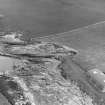
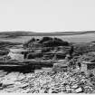
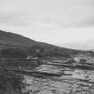
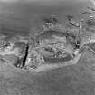
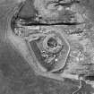
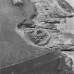
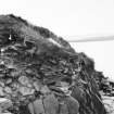
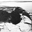
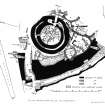
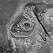
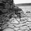
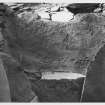
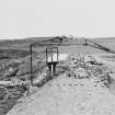
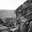
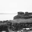
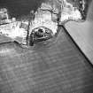
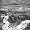
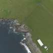
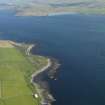
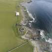
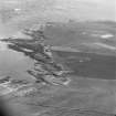
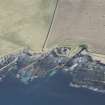
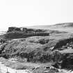
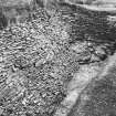
The broch and attendant buildings were excavated between 1930 and 1933 and then taken under guardianship. Before excavation there was only a grassy mound about 18' high with stones sticking through the surface in places, standing about 28' above low-water mark and occupying the landward end of a small promontory, which falls down to the water in a series of broad ledges, bounded on the SE and NW by the Stenchna Geo and the Geo of Brough.
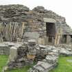
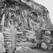
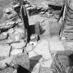
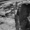
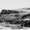
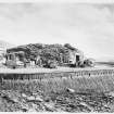
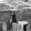
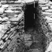
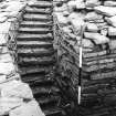
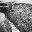
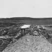
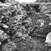
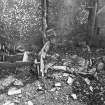
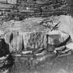
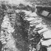
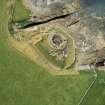
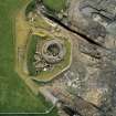
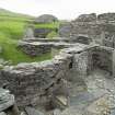
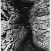
The tower is built in the centre of the promontory and measures 30' in diameter within a wall 15' thick still standing to a height of 14', which can be seen to be composed at the lower levels of two virtually separate skins. It stands within the precincts of an enclosure formed by a thick wall with a quarry ditch on either side. The outer face of the wall is steep if not sheer, the inner face considerable battered. It still stands to a height of 7' on the outside, and its width varies from 13' 6" to 19'. The broch contains many of the usual features, but particually well displayed-door-checks, bar-holes, guard-cells, galleries and stair case.
Outside the tower on all sides except the SW are the remains of later buildings. At least two periods of construction can be identified. After the erection of the earliest group of out-buildings there appears to have been a sagging in the N sector of the wall of the tower, and to prevent a total collapse it was buttressed on the outside, the lower gallery within the wall was filled along the greater part of its length with slabs set on edge and a stone casing was built against the inside of the wall at the weakened part. It is probable that, when these strengthening operations were carried out, a complete reconstruction of the inner court of the broch on quite a different plan was decided upon, and the buildings which survive today were erected.
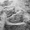
Two cup-marked stones were discovered built into the broch; one, which also showed ring-marks, was inserted low down in the outer wall of the tower of its NE side, and the other in a late building to the S of the main building.
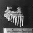
A large number of finds were found during the excavations and presented to the National Museum of Antiquities of Scotland (NMAS), objects of stone, bone and bronze, including a few Roman potsherds and fragments of a Roman patera.
R W Feachem 1963; RCAHMS 1946; J G Callander 1934; J Curle 1932; Proc Soc Antiq Scot 1937 (Donations); 1962 (Donations).
Mid How Broch (HBM [DoE] plaque), as described and illustrated in above authorities.
Re-surveyed at 1/2500
Visited by OS(AA) 11 October 1972.
Classification of Roman material.
A Robertson 1970.
HY 371 306 A watching brief was conducted in March 2004 on work required after the collapse of masonry from the revetment wall around the head of Stenchna Geo, a narrow inlet on the S side of the broch. The wall is not Iron Age in date, but a rebuild or enhancement of a 19th- or 20th-century field dyke. No finds were recovered and no soils of Iron Age date were noted.
Archive to be deposited in the NMRS.
Sponsor: HS.
P Sharman 2004
Antiquarian Observation (1870)
Four drawings by George Petrie of sites in Orkney in sketchbook no. 6 (MS 28/487/8) in the Society of Antiquaries of Scotland Collection.
Aerial Photography (1971)
Oblique aerial photographs of Midhowe broch, Rousay, by John Dewar in 1971.
Note (1982)
Midhowe HY 3716 3061 HY33SE 2
Broch, outbuildings and promontory-defence forework in SDD guardianship. Finds in NMAS.
RCAHMS 1982
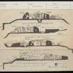
(Plans in Orkney Archives, copies in NMRS; Wilson Portfolio ff. 2-4; Curle 1932, 394; Callander and Grant 1934b; PSAS, 71, 1936-7, 19; RCAHMS 1946, ii, 193-200, No. 553; PSAS, 93, 1959-60, 253; Hamilton 1968; Robertson 1970, 202,208 and 210 with table II; Lamb 1980; OR 631)
Publication Account (1996)
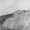
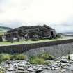
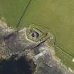
Midhowe is an excellent example of a broch built on a promontory with outer defences on the landward side, here consisting of a truly massive stone-built rampart with a ditch on either side. The area thus enclosed was originally larger than it survives now, for there has been considerable erosion and loss of external buildings on the west side of the broch. The sea wall built to protect the site in the 1930s is itself a superb building achievement, utilising to the full the qualities of the local flagstone. Nevertheless, the design of the broch and its defences is so compact, with the wall of the broch only a couple of metres from the inner ditch, that there can be no doubt that this was built as a prestigious, fortfied family house - the iron-age equivalent of the Norse castle on Wyre (no, 36). The external buildings round the broch were added later, when defence was no longer as vital, for they are built over the filled-in ditch and directly agains the rampart itself.
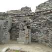
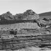
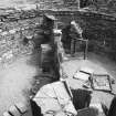
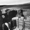
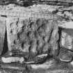
Instead of having a solid wall-base, the broch has a gallery within the wall at ground-level, a design that seems not to have been entirely successful because at some stage the gallery had partially to be filled with rubble and external buttressing to be built against the outer wall-face on the north side in order to prevent serious collapse (the buttressing was achieved by stacking vertical slabs just as in the 20th-century sea-wall, the same solution to similar problems almost 2000 years apart), The broch wall survives to a height of 4.3m, with an internal ledge for a first-floor gallery at a height of just over 3m, and the layout of the ground-floor is particularly interesting and well-preserved, bearing in mind that its present appearance reflects the final phase of its occupation and may not be entirely representative of earlier phases. Tall slabs were used to divide the somewhat crowded interior into two semi-circular rooms, each then subdivided further into cells and cupboards, and each with its hearth and stone-built water-tank. The main hearth in the southern room even retains the stonelined post-hole on either side which held the uprights for a spit over the fire, from which pots might be hung or joints of meat roasted. The underground cellar in the northern room may have been used for storing food supplies or it may once have been fed by a spring to be a freshwater supply. Perhaps the most remarkable feature of the broch interior is the alcove built to the immediate north of the entrance, a superb emonstration of some ancient stone-mason's skill and mastery of his resources. Balanced on a tall thin flagstone, itself almost 2.3m high, is a pier of drystone masonry which soars upwards to become a corbelled ceiling to the alcove.
Sufficient remains of the first floor of the broch to give a graphic impression of its arrangements. The stone ledge projecting from the broch-wall round the eastern half of the broch helped to support a wooden gallery (further support being provided by timber posts), to which there must have been access by means of a wooden ladder in the northern room, which also gave entry via a doorway in the brochwall to a stairway and upper gallery within the thickness of the wall. At a later stage, a stone stair was built in the southern room leading to a cell in the wall at first-floor level, which also had the effect of blocking the upper gallery in the wall. The timber-built first-floor was presumably used as sleeping accommodation, the ground-floor being taken up with cooking and storage facilities, while the stairs and gallery within the broch wall provided a means of access to the top of the broch tower.
Among the stones chosen by the broch-builders are two cup-marked boulders which were probably carved sometime in the second or early first
millennium BC. One is built into the south face of a fragmentary structure to the south of the broch, and the other, which is decorated with both cups and rings, is built into the outer face of the broch itself, low down on its north-north-east side. These two stones may well have been associated originally with the nearby chambered tomb (no. 81).
In common with most excavated brochs in Orkney, many artefacts were found in and around the broch, including some of Roman origin: sherds of distinctive pottery and fragments of a typical bronze ladle. The Northern Isles were well beyond the limits of Roman control in Scotland, and the presence of Roman objects such as these must be seen in the context of gifts, trade or raiding, probably not directly with the Romans but through intermediate native contacts. Other finds included a variety of bone and stone tools and bronze jewellery (now in NMS), and there was evidence to show that both bronze and iron had been manufactured on the site, including an ironsmelting hearth in one of the external buildings. Without the help of radiocarbon analysis, dating of this particular broch is likely to err on the conservative side, for several aspects of its design and later development suggest that it may well have been one of the earliest Orcadian brochs to be built as a true tower.
Information from ‘Exploring Scotland’s Heritage: Orkney’, (1996).
Watching Brief (9 March 2004 - 16 March 2004)
HY 371 306 A watching brief was conducted in March 2004on work required after the collapse of masonry from the revetment wall around the head of Stenchna Geo, a narrow inlet on the S side of the broch. The wall is not Iron Age in date, but a rebuild or enhancement of a 19th- or 20th-century field dyke. No finds were recovered and no soils of Iron Age date were noted.
P Sharman 2004
Sponsor: Historic Scotland
Kirkdale Archaeology
Project (June 2010)
HY 371 305 Students from Orkney College, under the supervision of staff from ORCA Geophysics and the Orkney College Department of Archaeology, undertook a geophysical survey at Westness in June 2010. The work consisted of a c1.4ha gradiometer and electromagnetic survey and a 40 x 20m GPR survey. The gradiometer results were dominated by an L-shaped ditch, which ran roughly E–W from the direction of the broch for c75m before curving sharply SSE–NNW for c40m. This feature was also recorded in the magnetic susceptibility Excavating the prehistoric structure on the beach at Swandro survey. Immediately to the N of the ditch was an area of enhanced magnetism, which may reflect the presence of enhanced soils, such as midden material in the vicinity of
the broch settlement. A N–S orientated positive anomaly, running perpendicular to and perhaps cut by the ditch, was extremely magnetic and may form the edge of the enhanced soils to the E of the broch. A Z-shaped negative anomaly, which may indicate the presence of a wall, was recorded in the N of the survey area. A positive linear feature was recorded running SSE–NNW to the E of the L-shaped ditch. This feature may represent a geological feature, but an archaeological interpretation cannot be ruled out. A curving anomaly, perhaps representing a ditched feature, in the SE of the survey area, seems to be anchored onto the S end of thelinear anomaly and may represent part of a field boundary. Adjacent to this, other seemingly conjoined curving and linear anomalies may represent further elements of a field system.
Archive: ORCA Geophysics
Funder: University of Bradford
Magnetometry (June 2010)
HY 371 305 Magnetometry survey.
Archive: ORCA Geophysics
Funder: University of Bradford
Electromagnetic (June 2010)
HY 371 305 Electromagnetic survey.
Archive: ORCA Geophysics
Funder: University of Bradford
Excavation (18 April 2011 - 19 April 2011)
HY 3716 3061 A small area around a hearth, exposed after the removal of its modern metal cover, was cleaned and recorded on 18–19 April 2011. The area had been partially excavated between 1929 and 1934 and it became clear that significant deposits are still in situ.
Archive: RCAHMS (intended)
Funder: Historic Scotland
Kirkdale Archaeology, 2011
Note (24 February 2015 - 31 May 2016)
The well-known broch at Midhowe, which was taken into Guardianship following the excavations of 1930-33 (Callander and Grant 1934), stands on a heavily eroded coastal promontory which is also defended on the landward side by a massive stone wall accompanied by both an internal and an external ditch. The broch itself measures about 9m in diameter within a wall 4.5m in thickness and displays numerous architectural features, including its entrance facing out to sea on the W. The outer wall is some 7.5m thick at the very base, where the inner and outer faces rise from the bottom of the flanking ditches. The entrance is adjacent to the S margin of the promontory, where the wall thickens to 9.5m, creating a long and relatively broad passage running back from a narrow opening through the outer face. Curiously, this opening does not conform symmetrically to the broad causeway that has been left undug in the outer ditch, and nor has the wall been carried to the edge of the adjacent geo, leaving ready access around its S end along the cliff-edge, where a flight of rock-cut steps gives access to the inner end of the entrance passage. The wall was not sectioned at the time of the excavations, but it is likely that the various observations made at the time, including a vertical joint in the outer face of the wall at the NW end, where the face is also founded on secondary paving in the bottom of the outer ditch, indicate a long and complicated history of construction, in one phase of which the wall probably returned along the S margin of the promontory and the only access to the interior may have been via the flight of steps leading from the terrace along the cliff-edge; in this light, there is no reason why the earliest phase of this wall may not have predated the construction of the broch, enclosing an area measuring about 40m from NW to SE immediately to the rear of the wall by at least 27m transversely (0.08ha), and perhaps as much as 40m given due allowance for the heavy erosion of the deposits on the seaward side (c. 0.15ha). Confined between the foot of the broch and the outer wall on the NE is a complex of later buildings, which also overlies the infilled inner ditch.
Information from An Atlas of Hillforts of Great Britain and Ireland – 31 May 2016. Atlas of Hillforts SC2846

