
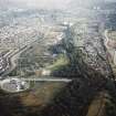
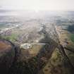
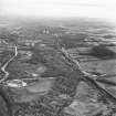
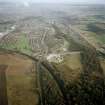
Grangemouth, Forth And Clyde Canal, General


Canal (Period Unassigned)
Site Name Grangemouth, Forth And Clyde Canal, General
Classification Canal (Period Unassigned)
Canmore ID 176155
Site Number NS98SW 62
NGR NS 93 82
Datum OSGB36 - NGR
Permalink http://canmore.org.uk/site/176155


- Council Falkirk
- Parish Grangemouth
- Former Region Central
- Former District Falkirk
- Former County Stirlingshire
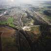
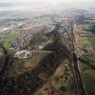
Various features of the Forth and Clyde Canal at Grangemouth photographed by J R Hume 8th July 1967. The descriptions accompanying the photographs are not specific enough to afford proper identification - there is more than one swing bridge at the mouth of more than one timber basin, likewise for entrance locks - and no NGRSs were supplied. Consequently the images were gathered together with the information supplied in the Description field.
Information from RCAHMS (SDC) 11.01.2001
EXTERNAL REFERENCE
Scottish Record Office
RHP 5541 Robert Whitworth 1789 - engraved plan of Grangemouth Port.
National Library
Scots Magazine. Report & a review concerning the Great Canal
1768 p.569 - text
1767 p.293 - text & plan of Forth Clyde valley

