
Flotta, Neb Battery


Coastal Battery (Second World War)
Site Name Flotta, Neb Battery
Classification Coastal Battery (Second World War)
Alternative Name(s) World War Ii
Canmore ID 173821
Site Number ND39SW 41.08
NGR ND 35031 92327
Datum OSGB36 - NGR
Permalink http://canmore.org.uk/site/173821


- Council Orkney Islands
- Parish Walls And Flotta
- Former Region Orkney Islands Area
- Former District Orkney
- Former County Orkney
ND39SW 41.08 35031 92327
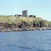
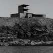
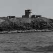
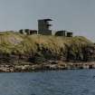
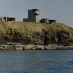
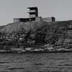
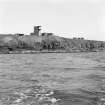
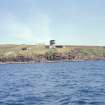
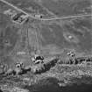
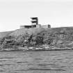
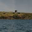
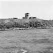
Neb WW II battery, twin 6-pounder gun emplacement with magazine, shelter, observation tower and engine room with associated searchlight emplacements.
The twin 6-pounder was installed in 1941 and removed in 1950.
Information from J Guy, 1993, Vol.1, 136-8, 140-141
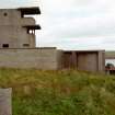
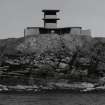
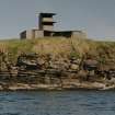
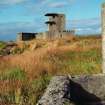
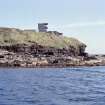
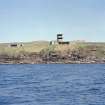
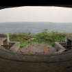
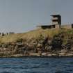
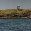
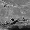
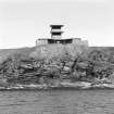
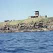
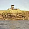
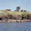
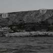
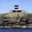
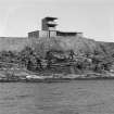
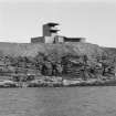
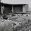
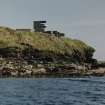
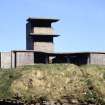
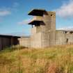
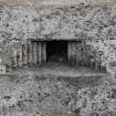
A twin 6-pounder gun emplacement, crew shelters and two storey observation tower is situated between two 12-pounder gun-emplacements almost at the edge of the cliff at Innan Neb.
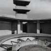
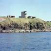
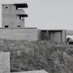
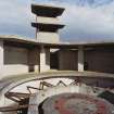
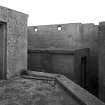
Constructed of reinforced concrete, brick and with steel beams, the gun position is set forward of a semi-circular canopy, which is supported by reinforced concrete columns and a steel beam at the rear with the observation tower centrally placed to the rear. A doorway leads from the rear of the gun position to a small courtyard in front of tower.
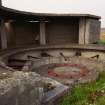
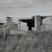
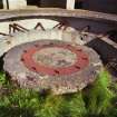
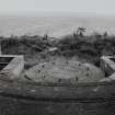
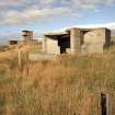
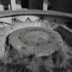
The holdfast, still with fixing bolts, is set on a circular concrete plinth supported by thin L-shaped steel girders all surrounded by a low concrete wall. The holdfast sits within a semi-circular platform, with steel tracks for assisting with the loading of shells set in the concrete on the top .
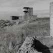
The two storey tower has at first floor level a canopied window and at the second floor a canopied open viewing platform. On each side of the observation tower are the crew rest room and what may be a small magazine for ready-use ammunition or a store.
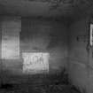
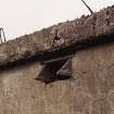
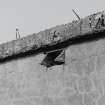
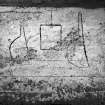
Some contemporary woodwork survives in situ, notably at vent holes in the store building. On the N wall of the store/magazine building graffitti against a white square of paint depicts three unknown items, two of which are ladle shaped.
The twin 6-pounder gun mounted during early 1941 and removed in July 1950. Designated 135 Battery, manning was by 533 Regiment (PRO WO 192/259, WO 199/2627 and WO 199/527).
Visited by RCAHMS (DE, GS, SW), August 1997
Field Visit (1997)
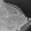
WWI & II Innan Neb, WWII Gate battery and Neb battery: (ND39SW 41, 50) 1915-1918, 1940-1944.
Elements located
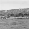
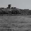
The Innan Neb Battery was originally constructed in 1915 to provide cover from the southern approach to Scapa Flow, via Switha Sound. Two 4.7 Quick Fire guns were emplaced and a boom was erected, running from Innan Neb to South Walls o n the island of Hoy. In 1940 it was brought back into use with the temporary emplacement of a 4.7 quick gun. This battery now served as a support for the new batteries at Neb and Gate. It was abandoned in 1944.
Gate battery was set up with the temporary installation of a single twelve-pounder gun in 1940. A second twelve-pounder was added, and later on, both guns were relocated to new concrete gun houses. This battery had the task of guarding the access point through the boom. Operations were ceased in 1945.
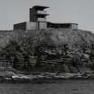
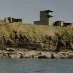
The Neb Battery comprised a twin six-pounder emplacement with a directing tower. It became operational in 1940 and continued in use up until the end of the war. It was charged with providing anti-motor-torpedo-boat protection.
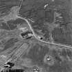
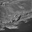
All three batteries are located close together, in fact, the two gun emplacements of the Gate battery are located to either side of the Neb battery. This, together with the overgrown nature of the site, makes it difficult to separate the various structures associated with each battery illustrated on the accompanying plan. [Note: There is no plan in the manuscript]
(i)This semi-subterranean rectangular structure is probably a magazine. It measures 10m by 5m, lies 2m form the cliff edge and is much obscured by vegetation.
(ii) Two semi-subterranean rectangular bunkers lie to either side of a raised concrete plinth. This structure served as a temporary gun emplacement for one of the twelve-pounder quick-fire guns supplied to the Gate battery in the early part of WWII. The battery lies 4m from the cliff edge. An earthwork curves from bunker to bunker to the rear of the position. A second, rectilinear earthwork lies 10m to the rear of the first.
(iii)The second Gate battery’s temporary gun position lies 20m W of (ii) and differs only in that it is surrounded by a single rectilinear earthwork. It lies 8m from the cliff edge.
(iv)This twin 4.7” quick-fire battery belongs to the WWI phase of Innan Neb battery. The gun emplacements are located 12m from the cliff edge. A curved rock-cut passage runs from each gun emplacement to a semi-subterranean rectangular concrete magazine building.
(v) Two concrete searchlight emplacements, each with three-slit openings, served both the Neb and Gate batteries. They are set into the cliff edge.
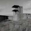
(vi) This complex is one of the two permanent twelve-pounder gun emplacements which constitute the Gate battery. The gun emplacement is surrounded by a graduated metal ring showing 0-360 degrees. A magazine and directing tower are located to the rear. The complex lies 2m from the cliff edge.
(vii) The Neb battery complex comprises an emplacement for a twin six-pounder gun, a directing tower and several ancillary buildings. It is located 2m from the cliff edge.
(viii) This is the second of the permanent emplacements which constituted the Gate battery. A magazine and directing tower are located to the rear. The complex lies 1.5m from the cliff edge.
(ix) An open-fronted concrete searchlight emplacement, which served both the Neb and Gate batteries, is set into the cliff edge.
(x) Two small concrete buildings, probably associated with wartime coastal defence operations, are situated within 5m of the coast edge.
P204 Photos
Orkney Coastal Zone Assessment 1997.

