 |
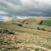
On-line Digital Images |
SC 578622 |
Records of the Royal Commission on the Ancient and Historical Monuments of Scotland (RCAHMS), Edinbu |
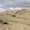
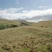
General view of Menstrie Glen from Backside of Lipney looking north-west across the glen. |
c. 1997 |
Item Level |
|
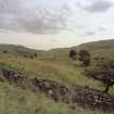 |
On-line Digital Images |
SC 579435 |
Records of the Royal Commission on the Ancient and Historical Monuments of Scotland (RCAHMS), Edinbu |
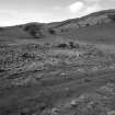
The remains of the dyke commissioned from Nicol McAleister and built between July and August 1758, can be seen in this ground view which looks SE down towards the steading at Loss. The stone outer face of the dyke, which is fronted by a ditch, is plainly visible. Scanned for Menstrie Glen publication |
1998 |
Item Level |
|
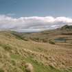 |
On-line Digital Images |
SC 579491 |
Records of the Royal Commission on the Ancient and Historical Monuments of Scotland (RCAHMS), Edinbu |
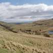
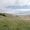
General view to south-east of Menstrie Glen from Ashentrool towards Loss.
Scan of D/59286/CN, ground view of Menstrie Glen. Scanned for Menstrie Glen publication. |
1998 |
Item Level |
|
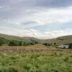 |
On-line Digital Images |
SC 584585 |
Records of the Royal Commission on the Ancient and Historical Monuments of Scotland (RCAHMS), Edinbu |
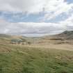
General view of Menstrie Glen from Ashentrool towards Loss. The stone dyke in the foreground is one of the new land divisions laid out in the 1760's. It marks the march between Ashentrool and Loss and the line of trees leading away on the left of the picture follows the boundary of the emparkemnt established between Loss and Townhead. |
1998 |
Item Level |
|
 |
On-line Digital Images |
SC 1346654 |
Records of the Royal Commission on the Ancient and Historical Monuments of Scotland (RCAHMS), Edinbu |
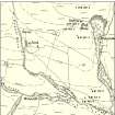
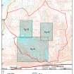
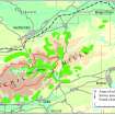
Map showing distribution of settlements in Menstrie Glen before the 1760s with head-dykes and cultivated ground. Fig 11 in "Well shelterd & watered" Menstrie Glen, a farming landscape near Stirling. |
2001 |
Item Level |
|
 |
On-line Digital Images |
SC 1346655 |
Records of the Royal Commission on the Ancient and Historical Monuments of Scotland (RCAHMS), Edinbu |
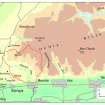
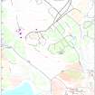
Map of the western end of the Ochils showing the location of Menstrie Glen. Fig 12 in "Well shelterd & watered" Menstrie Glen, a farming landscape near Stirling. |
2001 |
Item Level |
|
 |
On-line Digital Images |
SC 1346656 |
Records of the Royal Commission on the Ancient and Historical Monuments of Scotland (RCAHMS), Edinbu |
Map depicting arable land and settlement in the early 19th century. Fig 21 in "Well shelterd & watered" Menstrie Glen, a farming landscape near Stirling. |
2001 |
Item Level |
|
 |
On-line Digital Images |
SC 1346666 |
Records of the Royal Commission on the Ancient and Historical Monuments of Scotland (RCAHMS), Edinbu |
Illustration showing layout of farmsteads in the Menstrie Glen. Fig 31 in "Well shelterd & watered" Menstrie Glen, a farming landscape near Stirling. |
|
Item Level |
|
 |
On-line Digital Images |
SC 1346669 |
Records of the Royal Commission on the Ancient and Historical Monuments of Scotland (RCAHMS), Edinbu |
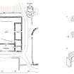
Publication drawing; plan of farmstead at Loss, with detail plan of fireplace A and reconstruction of fireplace B. |
2001 |
Item Level |
|
 |
On-line Digital Images |
SC 1346670 |
Records of the Royal Commission on the Ancient and Historical Monuments of Scotland (RCAHMS), Edinbu |
Details from OS 1st, 2nd and 3rd editions of Loss and Jerah farmsteads. Fig 35 in "Well shelterd & watered" Menstrie Glen, a farming landscape near Stirling. |
2001 |
Item Level |
|
 |
On-line Digital Images |
SC 1346671 |
Records of the Royal Commission on the Ancient and Historical Monuments of Scotland (RCAHMS), Edinbu |
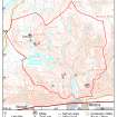
Map of Menstrie Glen showing locations of more detailed maps. Fig 39 in "Well shelterd & watered" Menstrie Glen, a farming landscape near Stirling. |
|
Item Level |
|
 |
On-line Digital Images |
SC 1346673 |
Records of the Royal Commission on the Ancient and Historical Monuments of Scotland (RCAHMS), Edinbu |
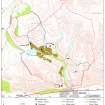
Map of Loss farm. Fig 43 in "Well shelterd & watered" Menstrie Glen, a farming landscape near Stirling. |
2001 |
Item Level |
|
 |
On-line Digital Images |
SC 1346675 |
Records of the Royal Commission on the Ancient and Historical Monuments of Scotland (RCAHMS), Edinbu |
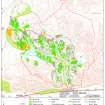
Map showing the extents of different types of rig in Menstrie Glen. Fig 48 in "Well shelterd & watered" Menstrie Glen, a farming landscape near Stirling. |
|
Item Level |
|
 |
On-line Digital Images |
SC 1346676 |
Records of the Royal Commission on the Ancient and Historical Monuments of Scotland (RCAHMS), Edinbu |
Map showing mine and trial sites in Menstrie Glen. Fig 54 in "Well shelterd & watered" Menstrie Glen, a farming landscape near Stirling. |
|
Item Level |
|
 |
On-line Digital Images |
SC 1346677 |
Records of the Royal Commission on the Ancient and Historical Monuments of Scotland (RCAHMS), Edinbu |
Extent of relict cultivation in the Ochil Hills. Fig 57 in "Well shelterd & watered" Menstrie Glen, a farming landscape near Stirling. |
|
Item Level |
|
 |
On-line Digital Images |
SC 1440968 |
Records of the Royal Commission on the Ancient and Historical Monuments of Scotland (RCAHMS), Edinbu |
General view of Menstrie Glen from Backside of Lipney looking north-west across the glen. |
1998 |
Item Level |
|
 |
On-line Digital Images |
SC 1440969 |
Records of the Royal Commission on the Ancient and Historical Monuments of Scotland (RCAHMS), Edinbu |
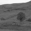
General view of Menstrie Glen from Ashentrool (NS89NW 56.00) looking south-east. |
1998 |
Item Level |
|
 |
On-line Digital Images |
SC 1440972 |
Records of the Royal Commission on the Ancient and Historical Monuments of Scotland (RCAHMS), Edinbu |
View of Menstrie Glen from Ashentool |
1998 |
Item Level |
|
 |
On-line Digital Images |
SC 1440973 |
Records of the Royal Commission on the Ancient and Historical Monuments of Scotland (RCAHMS), Edinbu |
General view of Menstrie Glen from Loss. |
1998 |
Item Level |
|
 |
On-line Digital Images |
SC 1440974 |
Records of the Royal Commission on the Ancient and Historical Monuments of Scotland (RCAHMS), Edinbu |
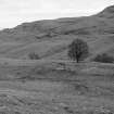
General view of Menstrie Glen from Ashentrool towards Loss. |
1998 |
Item Level |
|
 |
On-line Digital Images |
SC 1440975 |
Records of the Royal Commission on the Ancient and Historical Monuments of Scotland (RCAHMS), Edinbu |
View of farmstead and country house from north. |
1998 |
Item Level |
|
 |
On-line Digital Images |
SC 1440976 |
Records of the Royal Commission on the Ancient and Historical Monuments of Scotland (RCAHMS), Edinbu |
View of farmstead and country house from north. |
1998 |
Item Level |
|
 |
On-line Digital Images |
SC 1440977 |
Records of the Royal Commission on the Ancient and Historical Monuments of Scotland (RCAHMS), Edinbu |
Detail of fireplace (c.1680-1700) in east end of dwelling. |
1998 |
Item Level |
|
 |
On-line Digital Images |
SC 1440978 |
Records of the Royal Commission on the Ancient and Historical Monuments of Scotland (RCAHMS), Edinbu |
View of farmstead from east.
|
1998 |
Item Level |
|


