|
Photographs and Off-line Digital Images |
ST 9125 |
RCAHMS Aerial Photography |
Oblique aerial view. |
1982 |
Item Level |
|
|
Photographs and Off-line Digital Images |
ST 9126 |
RCAHMS Aerial Photography |
Oblique aerial view. |
1982 |
Item Level |
|
|
Photographs and Off-line Digital Images |
ST 9127 |
RCAHMS Aerial Photography |
Oblique aerial view. |
1982 |
Item Level |
|
|
Photographs and Off-line Digital Images |
ST 9128 |
RCAHMS Aerial Photography |
Oblique aerial view. |
1982 |
Item Level |
|
|
Manuscripts |
MS 731/19 |
Records of the Royal Commission on the Ancient and Historical Monuments of Scotland (RCAHMS), Edinbu |
Afforestable Land Survey field database (Menstrie Glen survey, 1997). Held as attribute table in GIS and in Oracle Field/AP table. Please see DX001444 |
1997 |
Item Level |
|
 |
On-line Digital Images |
SC 578622 |
Records of the Royal Commission on the Ancient and Historical Monuments of Scotland (RCAHMS), Edinbu |
General view of Menstrie Glen from Backside of Lipney looking north-west across the glen. |
c. 1997 |
Item Level |
|
 |
On-line Digital Images |
SC 579435 |
Records of the Royal Commission on the Ancient and Historical Monuments of Scotland (RCAHMS), Edinbu |
The remains of the dyke commissioned from Nicol McAleister and built between July and August 1758, can be seen in this ground view which looks SE down towards the steading at Loss. The stone outer face of the dyke, which is fronted by a ditch, is plainly visible. Scanned for Menstrie Glen publication |
1998 |
Item Level |
|
 |
On-line Digital Images |
SC 579491 |
Records of the Royal Commission on the Ancient and Historical Monuments of Scotland (RCAHMS), Edinbu |
General view to south-east of Menstrie Glen from Ashentrool towards Loss.
Scan of D/59286/CN, ground view of Menstrie Glen. Scanned for Menstrie Glen publication. |
1998 |
Item Level |
|
 |
On-line Digital Images |
SC 584585 |
Records of the Royal Commission on the Ancient and Historical Monuments of Scotland (RCAHMS), Edinbu |
General view of Menstrie Glen from Ashentrool towards Loss. The stone dyke in the foreground is one of the new land divisions laid out in the 1760's. It marks the march between Ashentrool and Loss and the line of trees leading away on the left of the picture follows the boundary of the emparkemnt established between Loss and Townhead. |
1998 |
Item Level |
|
|
Photographs and Off-line Digital Images |
D 57976 CN |
Records of the Royal Commission on the Ancient and Historical Monuments of Scotland (RCAHMS), Edinbu |
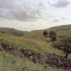
The remains of the dyke commissioned from Nicol McAleister and built between July and August 1758, can be seen in this ground view which looks SE down towards the steading at Loss. The stone outer face of the dyke, which is fronted by a ditch, is plainly visible. |
1998 |
Item Level |
|
|
Photographs and Off-line Digital Images |
D 57978 CN |
Records of the Royal Commission on the Ancient and Historical Monuments of Scotland (RCAHMS), Edinbu |
View of park dyke. |
1998 |
Item Level |
|
|
Photographs and Off-line Digital Images |
D 59295 |
Records of the Royal Commission on the Ancient and Historical Monuments of Scotland (RCAHMS), Edinbu |
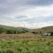
View of farmstead and country house from north. |
1998 |
Item Level |
|
|
Photographs and Off-line Digital Images |
D 59296 |
Records of the Royal Commission on the Ancient and Historical Monuments of Scotland (RCAHMS), Edinbu |
View of farmstead and country house from north. |
1998 |
Item Level |
|
|
Photographs and Off-line Digital Images |
D 59297 |
Records of the Royal Commission on the Ancient and Historical Monuments of Scotland (RCAHMS), Edinbu |
Detail of fireplace (c.1680-1700) in east end of dwelling. |
1998 |
Item Level |
|
|
Photographs and Off-line Digital Images |
D 59298 |
Records of the Royal Commission on the Ancient and Historical Monuments of Scotland (RCAHMS), Edinbu |
View of farmstead from east.
|
1998 |
Item Level |
|
|
Photographs and Off-line Digital Images |
D 59299 |
Records of the Royal Commission on the Ancient and Historical Monuments of Scotland (RCAHMS), Edinbu |
View of farmstead from east.
|
1998 |
Item Level |
|
|
Photographs and Off-line Digital Images |
D 59300 |
Records of the Royal Commission on the Ancient and Historical Monuments of Scotland (RCAHMS), Edinbu |
View of farmstead from east. |
1998 |
Item Level |
|
|
Photographs and Off-line Digital Images |
D 57977 |
Records of the Royal Commission on the Ancient and Historical Monuments of Scotland (RCAHMS), Edinbu |
View of park dyke. |
1998 |
Item Level |
|
|
Photographs and Off-line Digital Images |
D 59292 CN |
Records of the Royal Commission on the Ancient and Historical Monuments of Scotland (RCAHMS), Edinbu |
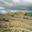
General view of Menstrie Glen from Loss. |
1998 |
Item Level |
|
|
Photographs and Off-line Digital Images |
D 59291 |
Records of the Royal Commission on the Ancient and Historical Monuments of Scotland (RCAHMS), Edinbu |
General view of Menstrie Glen from Loss. |
1998 |
Item Level |
|
|
Photographs and Off-line Digital Images |
D 5929O CN |
Records of the Royal Commission on the Ancient and Historical Monuments of Scotland (RCAHMS), Edinbu |
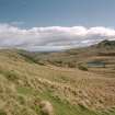
General view of Menstrie Glen from Ashentrool towards Loss. |
1998 |
Item Level |
|
|
Photographs and Off-line Digital Images |
D 59293 |
Records of the Royal Commission on the Ancient and Historical Monuments of Scotland (RCAHMS), Edinbu |
General view of Menstrie Glen from Ashentrool towards Loss. |
1998 |
Item Level |
|
|
Photographs and Off-line Digital Images |
D 59294 CN |
Records of the Royal Commission on the Ancient and Historical Monuments of Scotland (RCAHMS), Edinbu |
General view of Menstrie Glen from Ashentrool towards Loss. |
1998 |
Item Level |
|
|
Photographs and Off-line Digital Images |
D 57979 CN |
Records of the Royal Commission on the Ancient and Historical Monuments of Scotland (RCAHMS), Edinbu |
General view of Menstrie Glen from Ashentrool towards Loss. The stone dyke in the foreground is one of the new land divisions laid out in the 1760's. It marks the march between Ashentrool and Loss and the line of trees leading away on the left of the picture follows the boundary of the emparkemnt established between Loss and Townhead. |
1998 |
Item Level |
|


