
Fortrose, The Shore, Harbour


Harbour (19th Century)
Site Name Fortrose, The Shore, Harbour
Classification Harbour (19th Century)
Alternative Name(s) Fortrose Harbour, East And West Piers; Harbour Road; Fortrose Bay; Moray Firth
Canmore ID 14386
Site Number NH75NW 65
NGR NH 72479 56287
Datum OSGB36 - NGR
Permalink http://canmore.org.uk/site/14386


- Council Highland
- Parish Rosemarkie
- Former Region Highland
- Former District Ross And Cromarty
- Former County Ross And Cromarty
NH75NW 65.00 72479 56287
Harbour [NAT]
OS (GIS) AIB, April 2006.
NH75NW 65.01 NH 724 562 hand crane
NH75NW 65.02 NH 72423 56277 West Slipway
NH75NW 65.03 NH 72490 56350 East Slipway
For granary (Quay House) at NH 72473 56354, see NH75NW 67.
Location formerly entered as centred NH 72493 56258.
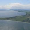
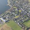
(Location cited as NH725563) Fortrose Harbour, repaired 1881. A small basin formed by two masonry piers, one on an L plan. On the larger pier is a hand-operated light crane mounted on standard-gauge flanged wheels. Now primarily a yacht harbour.
J R Hume 1977.
(Location cited as NH 724 563). To avoid confusion between Fortrose (also known as Chanonry of Ross) and its neighbour Rosemarkie (NH75NW 76), distant about 1.5 miles (2.4km) to the NE, a word of explanation is necessary. In the mid 17th century, Rosemarkie seems to have been in decline; a charter of 1641 confirmed its amalgamation with Fortrose. The place was of sufficient importance to be marked on Collins' chart (1776), though no harbour existed at that time. Petitions to the Convention of Royal Burghs for help in building one began in 1715, and in 1725, a voluntary contribution by all burghs and traders was approved. Local people believe that a harbour was built for the embarkation of troops in 1745, but no trace remains of what would have been a flimsy, hurried structure. A harbour was ultimately built in 1817. Gibb lists a 'new pier' 170ft (51.7m) long at Fortrose, and deepening of its harbour as having been carried out by T Telford between 1813 and 1817.
Structure
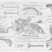
Thw E pier, quay and W pier, with head returning ENE, are all of large red stone blocks. (The W pier has a modern wall, with look-out box, heightening its parapet). The lower courses of the E pier look the oldest, but this could be the result of different sea-wear on the top three courses. Matching wooden pawls survive, as shown on the OS 1:2500 map (1871), one near the tip of the E pier, and two on the outer edge, below the parapet, of the W pier.
A Gibb 1935; A Graham and J Gordon 1988.
One of a variety of buildings; conservation area.
Harbour/slipway at Fortrose harbour (possibly accreting and mitigated against by dredging).
(The monument and coastal erosion form describing this site mislabelled the NMRS site number as NH75NW 72. This site has two forms)
CFA/MORA Coastal Assessment Survey 1998.
Construction (1817)
Completed 1817.
Constructed under direction of the Highland Roads Commission by John Watson. Designed by Telford.
R Paxton and J Shipway, 2007.
Publication Account (2007)
Fortrose Harbour
(Institute Civil Engineers Historic Engineering Works no. HEW 2108)
This harbour, designed by Telford, was constructed under the direction of Highland Roads Commission by John Watson and completed in 1817 at a cost of £4015. It is trapezoidal in plan, 120 ft by 150 ft with piers on two sides and, although repaired in 1881, remains an excellent example of its genre, largely in its original state.
Other similar small harbours in the vicinity built under Telford’s direction exist at Avoch (1815) and Portmahomack (1816).
R Paxton and J Shipway, 2007.
Reproduced from 'Civil Engineering heritage: Scotland - Highlands and Islands' with kind permission from Thomas Telford Publishers.
Publication Account (2007)
Avoch (NH75NW 72.0, 1815), Fortrose Harbour (NH75NW 65.0, 1817) and Portmahomack Harbour (NH98SW 28, 1816), in vicinity of each other, all similar and built under supervision of Thomas Telford.
R Paxton and J Shipway, 2007

