
Pricing Change
New pricing for orders of material from this site will come into place shortly. Charges for supply of digital images, digitisation on demand, prints and licensing will be altered.
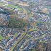
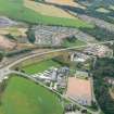
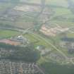
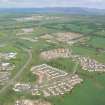
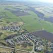
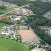
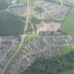
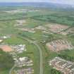
Culduthel


Ring Cairn (Neolithic) - (Bronze Age)
Site Name Culduthel
Classification Ring Cairn (Neolithic) - (Bronze Age)
Canmore ID 13508
Site Number NH64SE 26
NGR NH 6619 4176
Datum OSGB36 - NGR
Permalink http://canmore.org.uk/site/13508


- Council Highland
- Parish Inverness And Bona
- Former Region Highland
- Former District Inverness
- Former County Inverness-shire
NH64SE 26 6619 4176.
(NH 66194176) Stone Circle [NR] (Remains of)
OS 6"map, Inverness-shire, 2nd ed., (1906)
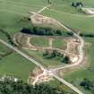
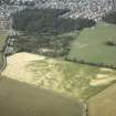
Clava-type cairn, Culduthel: 'The cairn has been placed on a small natural rise. It is now at the edge of a patch of thin woodland. It has been so completely robbed that only a few stones of the peristalith remain in situ and a few more stones lie where they have fallen outwards form their original positions. The stones are considerable rounded boulders set on end, four of them contiguous. They vary in height from 1 foot 9 inches to 4 feet, the tallest being in the middle of the existing setting. There can be little doubt that they represent part of the south arc of a cairn kerb though they are not arranged on a true circle. On the OS 6"map of 1871 the site is marked as an almost complete circle lacking only part of the west side'.
A S Henshall 1963, visited 11 April 1957; J Fraser 1884, A Low 1929.
The remains of this cairn are described above.
Visited by OS (J L D) 22 March 1962.
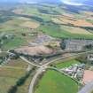
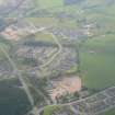
NH 660 417 An evaluation was undertaken in May 2004 prior to housing development. A ring-cairn (NH64SE 26) assumed to be of the Clava type lies immediately NE of the site.
Thirteen trenches (2000m2) were stripped, equivalent to 5% of the development area. Only one archaeological feature was uncovered, at the southern end of the site. This was a pit, circular in plan and filled with a charcoal-rich deposit. It was apparently isolated and no datable finds were recovered from the fill.
Reports lodged with Highland SMR and the NMRS.
Sponsor: Tulloch Homes Ltd.
M Hastie 2004
Field Visit (14 August 1943)
This site was recorded as part of the RCAHMS Emergency Survey, undertaken by Angus Graham and Vere Gordon Childe during World War 2. The project archive has been catalogued during 2013-2014 and the material, which includes notebooks, manuscripts, typescripts, plans and photographs, is now available online.
Information from RCAHMS (GF Geddes) 12 November 2014.
Field Visit (June 1978)
Culduthel (INV 22) NH 661 417 NH64SE 26
A few kerb-stones are all that survives of this Clava cairn.
RCAHMS 1979, visited June 1978
(Henshall 1963-72, i, 372)

