|
Manuscripts |
MS 5580 |
Records from Headland Archaeology Ltd, archaeologists, Edinburgh, Scotland |
Report on monitoring at Culduthel Phase 6, Inverness. |
10/2006 |
Item Level |
|
 |
Digital Files (Non-image) |
WP 000789 |
Records of the Royal Commission on the Ancient and Historical Monuments of Scotland (RCAHMS), Edinbu |
RCAHMS Emergency Survey: Typescripts (Inverness). |
1942 |
Item Level |
|
 |
Digital Files (Non-image) |
WP 002403 |
Records of the Royal Commission on the Ancient and Historical Monuments of Scotland (RCAHMS), Edinbu |
Scanned copy of RCAHMS Emergency Survey: Manuscripts (1943 Volume 2). |
1943 |
Item Level |
|
 |
Digital Files (Non-image) |
WP 003643 |
Stuart Farrell |
Report of Archaeological Desktop & Walkover Survey, for Young Associates Ltd, of the Inverness Flood Relief Scheme.
|
6/2004 |
Item Level |
|
|
Manuscripts |
MS 36/275 |
Records of the Royal Commission on the Ancient and Historical Monuments of Scotland (RCAHMS), Edinbu |
RCAHMS Emergency Survey; manuscripts 1943 (vol.2) |
1943 |
Item Level |
|
|
Photographs and Off-line Digital Images |
J 11993 CS |
Papers of Professor Geraint Dyfed Barri Jones, archaeologist, Manchester, England |
Oblique aerial view |
25/7/1995 |
Item Level |
|
 |
On-line Digital Images |
SC 1592887 |
Papers of Professor Geraint Dyfed Barri Jones, archaeologist, Manchester, England |
Oblique aerial view |
25/7/1995 |
Item Level |
|
 |
On-line Digital Images |
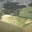
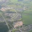
SC 1868260 |
Papers of James Sloan Bone, landscape historian, Inverness, Highland, Scotland |
Aerial view of Culduthel Mains, Inverness, looking SE. |
2004 |
Item Level |
|
 |
On-line Digital Images |
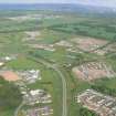
DP 340928 |
Papers of James Sloan Bone, landscape historian, Inverness, Highland, Scotland |
Aerial view of Culduthel development, Inverness, looking WSW. |
14/8/2007 |
Item Level |
|
 |
On-line Digital Images |
DP 340937 |
Papers of James Sloan Bone, landscape historian, Inverness, Highland, Scotland |
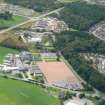
Aerial view of Inverness Royal Academy, oblique view, looking SW towards Culduthel. |
14/8/2007 |
Item Level |
|
 |
On-line Digital Images |
DP 340938 |
Papers of James Sloan Bone, landscape historian, Inverness, Highland, Scotland |
Aerial view of Inverness Royal Academy, oblique view, looking SW towards Culduthel development. |
14/8/2007 |
Item Level |
|
 |
On-line Digital Images |
DP 341839 |
Papers of James Sloan Bone, landscape historian, Inverness, Highland, Scotland |
Aerial view of Lochardil and Inverness Royal Academy with A8082, Inverness, looking SE. |
18/9/2009 |
Item Level |
|
 |
On-line Digital Images |
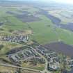
DP 341840 |
Papers of James Sloan Bone, landscape historian, Inverness, Highland, Scotland |
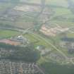
Aerial view of new housing development at Lochardil, Inverness, S of A8082, looking SE. |
18/9/2009 |
Item Level |
|
 |
On-line Digital Images |
DP 341841 |
Papers of James Sloan Bone, landscape historian, Inverness, Highland, Scotland |
Aerial view of new housing development at Lochardil, Inverness, S of A8082, looking SE. |
18/9/2009 |
Item Level |
|
 |
On-line Digital Images |
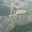
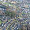
DP 342174 |
Papers of James Sloan Bone, landscape historian, Inverness, Highland, Scotland |
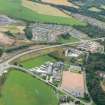
Aerial view of housing development around Culduthel Mains Roundabout, Inverness, looking E. |
30/5/2010 |
Item Level |
|
 |
On-line Digital Images |
DP 342175 |
Papers of James Sloan Bone, landscape historian, Inverness, Highland, Scotland |
Aerial view of building development around the Leys Roundabout on the Inverness Southern Distributor Road (A8082), looking E. |
30/5/2010 |
Item Level |
|
 |
On-line Digital Images |
DP 342585 |
Papers of James Sloan Bone, landscape historian, Inverness, Highland, Scotland |
Aerial view of Southern Distributor Road (A8082), Inverness, looking E. |
3/2/2012 |
Item Level |
|
 |
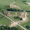
On-line Digital Images |
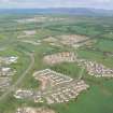
DP 342708 |
Papers of James Sloan Bone, landscape historian, Inverness, Highland, Scotland |
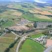
Aerial view of Culduthel Mains development, Inverness, looking S. |
26/3/2012 |
Item Level |
|
 |
Digital Files (Non-image) |
WP 007517 |
Publications by the Royal Commission on the Ancient and Historical Monuments of Scotland |
(8) The Archaeological Sites and Monuments of North-east Inverness, Inverness District |
10/1979 |
Item Level |
|
 |
On-line Digital Images |
SC 2364270 |
Records of the Ordnance Survey, Southampton, Hampshire, England |
Culduthel, NH64SE 26, Ordnance Survey index card, page number 1, Recto |
1958 |
Item Level |
|
 |
On-line Digital Images |
SC 2364271 |
Records of the Ordnance Survey, Southampton, Hampshire, England |
Culduthel, NH64SE 26, Ordnance Survey index card, page number 2, Verso |
1958 |
Item Level |
|
 |
On-line Digital Images |
SC 2364272 |
Records of the Ordnance Survey, Southampton, Hampshire, England |
Culduthel, NH64SE 26, Ordnance Survey index card, Recto |
1958 |
Item Level |
|
|
All Other |
551 166/1/1 |
Records of the Ordnance Survey, Southampton, Hampshire, England |
Archaeological site card index ('495' cards) |
1947 |
Sub-Group Level |
|


