
Scheduled Maintenance
Please be advised that this website will undergo scheduled maintenance on the following dates: •
Tuesday 3rd December 11:00-15:00
During these times, some services may be temporarily unavailable. We apologise for any inconvenience this may cause.
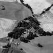
Tarradale House


Barrow Cemetery (Prehistoric), Enclosure (Medieval)(Possible)
Site Name Tarradale House
Classification Barrow Cemetery (Prehistoric), Enclosure (Medieval)(Possible)
Canmore ID 12682
Site Number NH54NW 23
NGR NH 5484 4891
Datum OSGB36 - NGR
Permalink http://canmore.org.uk/site/12682


- Council Highland
- Parish Urray (Ross And Cromarty)
- Former Region Highland
- Former District Ross And Cromarty
- Former County Ross And Cromarty
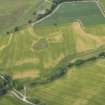
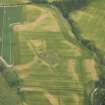
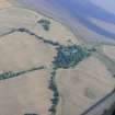
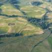
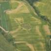
NH 548 489 Cropmark of an (?bivallate) enclosure, c 30m diameter, with two linear cropmarks extending to NW. The SE edge of the ditched enclosure touches the pentagonal 'castle' site, to the NW of Tarradale House. Possibly in RCAHMS catalogue of APs, 1978, 18.
J S Bone 1996
Note (1979)
Tarradale House 1 NH 548 489 NH54NW
Air photography has revealed the crop-marks of the NE side, and parts of the NW and SE sides, of a rectilinear enclosure 450m WNW of Tarradale House; it measures 33m by at least 38m within a ditch about 1.5m broad. See also NH54NW 25
RCAHMS 1979
Field Visit (2012)
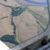
NH 54 48, NH 54 49, NH 55 48 and NH 55 49 The Tarradale Archaeological Project (an approved NOSAS project) aims to investigate, record and interpret the multi-period archaeological landscape of the Tarradale area and to identify the main periods of settlement and resource utilisation. Tarradale was formerly a parish itself, covering about 750ha of land at the W end of the Black Isle and immediately E of Muir of Ord. The area currently being studied consists of raised estuarine beaches underlying flat, high quality, agricultural land. Apart from the medieval Gilchrist Chapel and a small area of irregular mounds, few standing or surface archaeological monuments survive in an area that is intensively ploughed, although aerial photographs show cropmarks that can be interpreted as ring ditches, pits and enclosures, with one concentration of ring and square ditches suggesting the presence of a Late Iron Age/Early Historic barrow cemetery. This contrasts with the more upland pastoral and wooded landscape where there are standing monuments including chambered cairns, one of which is the Tarradale chambered cairn.
Fieldwalking in the fields to the E and W of Tarradale House early in 2012 produced 237 lithic finds, mainly flint and many of them of microlithic size. The density of finds in relation to the area covered is low and most of the lithic finds are very small and difficult to see in a soil that is derived from coarse sand and pebbles. It appears that quartz and quartzite were also being used for artefact manufacture, probably due to the shortage of flint which does not occur naturally in the area. The project steering group decided that intensive fieldwalking should be undertaken by parallel traverses spaced 1m apart, with individual lithic, early pottery and metalwork find sites plotted using GPS. This essentially meant that all the surface area was being visually scanned for artefact survival.
The majority of the lithic finds can be classified as debitage, but there are a number of reworked flakes, end scrapers and side scrapers. An analysis of their distribution has led to the preliminary identification of a number of potential ‘hot spots’. Lithic finds also included a few larger flakes as well as a tanged and barbed arrowhead, and a number of stone spindle whorls. The lithic finds have not yet undergone detailed analysis. Supervised metal detecting of the ploughsoil revealed the broken off cutting edge of a Late Bronze Age socketed axe and a lead spindle whorl.
Fieldwalking and controlled metal detecting has also provided a picture of a general background noise of medieval pottery and a few medieval coins (for example a silver short cross penny of King Henry III of England, issued 1216–47). However, fieldwalking finds from part of one field (centred on NH 554 487) showed a well defined concentration of degraded pottery sherds, animal bone food waste and iron nails which may indicate the lost location of the former medieval Tarradale Castle that was destroyed by Robert Bruce in 1308. Supervised metal detecting of the ploughsoil in the supposed castle area produced a Henry III long cross penny and a medieval heraldic horse pendant.
Ploughing by the tenant farmer in November 2011 in the field immediately W of Tarradale House (centred on NH 548 487) brought to the surface a dense spread of marine shells, including whole oyster, cockle, mussel, whelk and periwinkle shells, as well as a mass of crushed shells. Two smaller surface spreads of shells were noted close by in an adjacent field. Given that harrowing would destroy the surface evidence, test pitting was carried out in November 2011 to attempt to assess the nature and extent and possible age of these deposits. The test pits provided incontrovertible evidence that there was good preservation of an extensive shell layer below the ploughsoil, though suffering continual degradation due to ploughing. A series of small augur boreholes was sunk to try and delimit the shell layer which was found potentially to cover 500m² and in places is up to 400mm thick and contains many millions of shells. Analysis of a sample of these shells (all of which can be found in the Beauly Firth today) shows a considerable size variation, particularly for periwinkles, with the presence of some tiny periwinkles suggesting that these molluscs were collected by bulk methods. Some of the test pits also produced pieces of antler and bone as well as spreads of charcoal within the shell layer, suggesting that it is a humanly created shell midden rather than a natural deposit of shells. The project is actively seeking funding for radiocarbon dating of these organic deposits to provide an initial chronological parameter for the site.
Archive: Highland HER, local library and RCAHMS (intended)
Funder: NOSAS – in kind
Eric Grant, Tarradale Archaeological Project, 2012
(Source: DES)
Geophysical Survey (2013)
NH 54 48, NH 54 49, NH 55 48 and NH 55 49 The Tarradale Archaeological Project (an approved NOSAS project) continued in 2013. Fieldwalking in the fields to the E, W and N of Tarradale House produced almost 300 lithic finds, mainly flint, and many of them of microlithic size, making the total recorded to over 500 lithics. The majority of the lithic finds can be classified as debitage but there are a number of reworked flakes, end scrapers and side scrapers. All lithic finds are plotted by GPS and analysis of the mapped distribution shows a distinct concentration along an abandoned shoreline 10–15m above current OD and up to 200m inland from the Beauly Firth. This distribution also includes the inferred sites of seven shell middens identified from the presence of marine mollusc shells in the ploughsoil. In 2011 test pitting at the site of a spread of recently ploughed up marine molluscs demonstrated the existence of a very large shell midden, which also contained pieces of bone and antler. Radiocarbon dates for these were obtained in 2013 (courtesy of the University of Aberdeen) and dated the shell midden to the seventh millennium BC (hazel charcoal was dated to 6632–6480 cal BC and antler to 6204–6005 cal BC, both at 95.4% probability). Other lithic finds from fieldwalking in 2013 included a fine leaf-shaped arrowhead, a triangular arrowhead and a tanged and barbed arrowhead. Fieldwalking on the site of the inferred Tarradale Castle produced further eroded sherds of medieval pottery, iron nails and animal food wastes.
In February 2013 the University of Aberdeen carried out a geophysical survey in a field where aerial photographs strongly suggest the presence of a barrow cemetery, with both round- and square-ditched barrows (centred on NH 5485 4890). This investigation included magnetic susceptibility of the wider area of the cemetery, with results suggesting that some barrows identifiable in earlier aerial photographs may no longer survive under the eroding ploughsoil. A resisitivity survey of a smaller area in a more favourable location showed the presence of at least one square barrow.
Archive: Highland HER, local library and RCAHMS (intended)
Funder: NOSAS (in kind) and University of Aberdeen
Eric Grant, Tarradale Archaeological Project, 2013
(Source: DES)
2013
Field Walking (January 2015 - March 2015)
NH 53 48, NH 53 49, NH 54 48, NH 54 49, NH 55 48, NH 55 49 Fieldwalking continued from January to March 2015 in the period between ploughing and sowing. The aim is to walk every ploughed field within the Tarradale study area at least twice. The fields nearest Tarradale House have now been walked twice and in 2015 the project concentrated on fieldwalking further W around Gilchrist Church, the old parish church of the former parish of Tarradale (now a mausoleum). Increased presence of medieval pottery was identified in the fields close to the church along with a specific concentration of medieval pottery suggestive of a homestead site. A silver sixpence of Queen Elizabeth I (dated 1581) was found near Gilchrist Church.
Stone axe probably from Creag na Caillich axe factory, near Killin The usual range of lithics was found throughout the wider study area, including artefacts identifiable as Mesolithic, as well as Neolithic and Bronze Age projectile points, blades and scrapers. Two barbed and tanged flint arrowheads were found as well as a broken leaf shaped arrowhead. A small piece of Rum bloodstone debitage was found but the most significant lithic find of the fieldwalking season was the major part of a polished green-stone axe, probably from Creag na Caillich, Killin. All lithic finds are plotted by GPS and a distinct pattern of concentration of Mesolithic type lithics has been identified immediately inland of a post-glacial abandoned shoreline which is present today as a degraded sandy cliff. A number of shell middens has been identified above and below this former shoreline and fieldwalking identified an additional shell midden site near Bellevue Farm.
In addition to fieldwalking, NOSAS members also sorted and identified medieval and post-medieval pottery, slag, nails and other metals found by fieldwalking This indoor activity is helping to create an understanding of the source of the medieval and post-medieval pottery and other found artefacts which can be used for further analysis as well as a reference collection. Controlled metal detecting also yielded a considerable number of mainly post-medieval artefacts including 17th-century Scottish coins (ie Turners) as well as shoe buckles, pieces of horse harness, musket balls and other commonplace metal detecting finds. A 13th-century silver penny was found, making a total of six silver pennies found in the area around the inferred site of Tarradale Castle.
The most significant activity of the season was a small excavation on the site of one of the shell middens close to Tarradale House. This was unexpectedly discovered during coring in a small area of the presumed site of Tarradale Castle. The coring had been undertaken to assess the archaeological potential of a small area of land which is not currently ploughed. No trace of the medieval castle was found in the area tested (apart from one piece of medieval pottery) but a test pit revealed a clear layer of shells below an older plough soil. The test pit was extended into a trench, and this showed that the shell midden covered at least 10m² and probably considerably more. This small excavation, in October 2015, showed that the shell midden lay directly on a former raised beach largely made up of cobbles, pebbles and gravel which probably represented materials sorted by marine action from the fluvio-glacial sands and gravels that underlie the whole area of raised estuarine beaches.
In addition to a wide range of molluscs similar to that found in the shell midden investigated four years ago, the current shell midden also yielded a number of pieces of animal bone including two dog teeth as well as an antler tine and small deposits of charcoal and what may be carbonised
seeds. The upper levels of the midden had been disturbed by the creation of rig and furrow, of indeterminate date, and the upper horizon of the midden reflected the wavelike pattern of rigs. Where the furrows had been created, the surviving shell midden was thinner and there was evidence of the furrows having initially been hand dug, with spits of midden material mixed with soil thrown up on top of the surviving rigs. The rig and furrow is just apparent on the
current ground surface and has probably survived as this area is too small for ploughing with modern machinery and has been left fallow.
The main area of the midden appears to be at a height of c9m OD (the midden excavated four years ago was at a height of over 20m OD) and it is not known how the current midden may chronologically relate to the previously investigated midden and other middens in the study area. The southern extent of the midden had clearly been destroyed where modern ploughing had truncated the site. One piece of flint with use wear on two edges was found in the midden, but in the field immediately to the S of the midden a considerable number of lithics and bone fragments have been found during fieldwalking, and they are now considered to have come from near or at least been associated with the recently excavated midden. At the time of writing, post excavation
analysis of the finds had just commenced.
Archive: Tarradale House (currently), Highland HER and National Record of the Historic Environment (NRHE) intended
Funder: NOSAS (In kind plus some post excavation costs)
Eric Grant - NOSAS
(Source: DES, Volume 16)
Field Walking (January 2015 - March 2015)
NH 53 49, NH 54 48, NH 54 49, NH 55 48, NH 55 49 Fieldwalking continued from January to March 2015 in the period between ploughing and sowing. The aim is to walk every ploughed field within the Tarradale study area at least twice. The fields nearest Tarradale House have now been walked twice and in 2015 the project concentrated on fieldwalking further W around Gilchrist Church, the old parish church of the former parish of Tarradale (now a mausoleum). Increased presence of medieval pottery was identified in the fields close to the church along with a specific concentration of medieval pottery suggestive of a homestead site. A silver sixpence of Queen Elizabeth I (dated 1581) was found near Gilchrist Church.
Stone axe probably from Creag na Caillich axe factory, near Killin The usual range of lithics was found throughout the wider study area, including artefacts identifiable as Mesolithic, as well as Neolithic and Bronze Age projectile points, blades and scrapers. Two barbed and tanged flint arrowheads were found as well as a broken leaf shaped arrowhead. A small piece of Rum bloodstone debitage was found but the most significant lithic find of the fieldwalking season was the major part of a polished green-stone axe, probably from Creag na Caillich, Killin. All lithic finds are plotted by GPS and a distinct pattern of concentration of Mesolithic type lithics has been identified immediately inland of a post-glacial abandoned shoreline which is present today as a degraded sandy cliff. A number of shell middens has been identified above and below this former shoreline and fieldwalking identified an additional
shell midden site near Bellevue Farm.
In addition to fieldwalking, NOSAS members also sorted and identified medieval and post-medieval pottery, slag, nails and other metals found by fieldwalking This indoor activity is helping to create an understanding of the source of the medieval and post-medieval pottery and other found
artefacts which can be used for further analysis as well as a reference collection. Controlled metal detecting also yielded a considerable number of mainly post-medieval artefacts including 17th-century Scottish coins (ie Turners) as well as shoe buckles, pieces of horse harness, musket balls and other commonplace metal detecting finds. A 13th-century silver penny was found, making a total of six silver pennies found in the area around the inferred site of Tarradale Castle.
The most significant activity of the season was a small excavation on the site of one of the shell middens close to Tarradale House. This was unexpectedly discovered during coring in a small area of the presumed site of Tarradale Castle. The coring had been undertaken to assess the archaeological potential of a small area of land which is not currently ploughed. No trace of the medieval castle was found in the area tested (apart from one piece of medieval pottery) but a test pit revealed a clear layer of shells below an older plough soil. The test pit was extended into a trench, and this showed that the shell midden covered at least 10m² and probably considerably more. This small excavation, in October 2015, showed that the shell midden lay directly on a former raised beach largely made up of cobbles, pebbles and gravel which probably represented materials sorted by marine action from the fluvio-glacial sands and gravels that underlie the whole area of raised estuarine beaches.
In addition to a wide range of molluscs similar to that found in the shell midden investigated four years ago, the current shell midden also yielded a number of pieces of animal bone including two dog teeth as well as an antler tine and small deposits of charcoal and what may be carbonised seeds. The upper levels of the midden had been disturbed by the creation of rig and furrow, of indeterminate date, and the upper horizon of the midden reflected the wavelike pattern of rigs. Where the furrows had been created, the surviving shell midden was thinner and there was evidence of the furrows having initially been hand dug, with spits of midden material mixed with soil thrown up on top of the surviving rigs. The rig and furrow is just apparent on the current ground surface and has probably survived as this area is too small for ploughing with modern machinery and has been left fallow.
The main area of the midden appears to be at a height of c9m OD (the midden excavated four years ago was at a height of over 20m OD) and it is not known how the current midden may chronologically relate to the previously investigated midden and other middens in the study area. The southern extent of the midden had clearly been destroyed where modern ploughing had truncated the site. One piece of flint with use wear on two edges was found in the midden, but in the field immediately to the S of the midden a considerable number of lithics and bone fragments have been found during fieldwalking, and they are now considered to have come from near or at least been associated with the recently excavated midden. At the time of writing, post excavation analysis of the finds had just commenced.
Archive: Tarradale House (currently), Highland HER and National Record of the Historic Environment (NRHE) intended
Funder: NOSAS (In kind plus some post excavation costs)
Eric Grant - NOSAS
(Source: DES, Volume 16)

