RCAHMS National Archaeological Survey: South-east Perth


Date October 1986 - January 1993
Event ID 1095650
Category Project
Type Project
Permalink http://canmore.org.uk/event/1095650
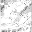
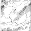
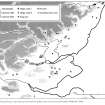
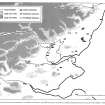
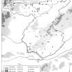
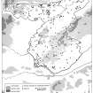
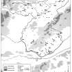
"The publication of South-east Perth completes the archaeological recording-programme whose object, when commenced in October 1986, was to survey the entire eastern portion of Perth and Kinross District, Tayside Region, and provides a companion volume to North-east Perth: an archaeological landscape (RCAHMS 1990). That volume marked a significant departure from many of the practices that have characterised Commission surveys over the last eighty years, and its preface drew attention to several fundamental changes in the approach to survey and publication. The most significant of these is the designation of the archives of the National Monuments Record of Scotland as the ‘Inventory of Ancient and Historical Monuments and Constructions' whose compilation was entrusted by Royal Warrant to the Commissioners. Thus, the emphasis of the work in North-east and South-east Perth, and all future projects, lies in the enhancement of the Record, where all survey information is made available for public inspection.
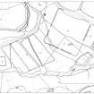
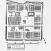
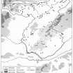
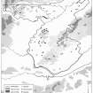
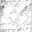
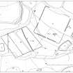
North-east Perth presented a distillation of the descriptive material recorded in the course of the survey, organised within framework like that of the old county Inventories, but viewing the archaeology as an element of the landscape. Internal review of that publication, and the difficulties of dealing with the cropmark evidence of this volume in terms of traditional archaeological categories, have led to a radical reappraisal of the Commission's approach to the contents of survey-publications. While the brief of survey remains the same- to identify, accurately map, describe, interpret and selectively illustrate the archaeological monuments of an area - the objectives of the publication have been refocussed, to characterise and interpret the archaeology. In this sense, the changes initiated by North-east Perth have been taken a stage further, and no attempt has been made in this volume to provide a detailed description of each site within the area of South-east Perth; that is the role of the Record-entries in the National Monuments Record of Scotland (which are available to the public for personal inspection, as well as by print-out or photocopy on application by post and telephone).The recorded evidence is discussed under major thematic headings and sub-headings, with additional sections setting the material in a wider context. Locational information and references for each of the known archaeological sites and monuments in the survey-area are provided in a brief gazetteer at the end of the volume.
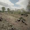
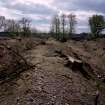
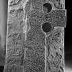
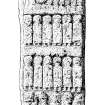
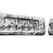
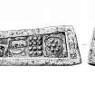
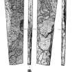
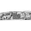
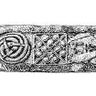
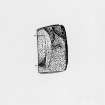
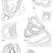
The survey has been mainly concerned with archaeological evidence, and items included range from flint scatters of Mesolithic date to farmsteads abandoned in the last century. All sites and monuments that can be shown to date from before 1600 have been recorded, but thereafter the emphasis of the work has lain in the identification of the farmsteads and buildings of the pre-Improvement rural landscape. With the small numbers of staff available for the project, it has not been possible to quarter the ground exhaustively, or to walk arable fields in search of artefact scatters. Nevertheless, all the areas of the hills that have escaped modern cultivation have been examined by teams of two, and other likely areas of survival in the lowlands have been briefly inspected. For similar reasons, it has not been practical to record all the old trackways and the fragments of rig-systems that survive in the Sid laws, although such remains have been noted in passing where they lie adjacent to other categories of recorded site or have been revealed by oblique aerial photography. All structures shown roofed on the first edition of the OS 6-inch map (1860s) have been omitted, and no account has been taken of any remains of more recent date.
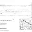
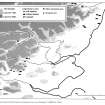
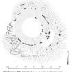
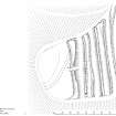
The bulk of the fieldwork took place in 1989, between March and November, but some additional site-visits were carried out in the summer of 1992. All the results of oblique aerial photography prior to April 1992 have been examined in the course of the survey. The 1992 flying programme has produced remarkable results from many parts of Scotland, but, with the exception of the probable mortuary enclosures at Upper Gothens and Carsie Mains, it has not proved possible to incorporate the new material from Southeast Perth into either the gazetteer or the distribution maps; for information about the latter, the reader is referred to forthcoming Catalogues of Aerial Photographs.
Fieldwork for the survey has been carried out by John Borland, BA, MAAIS, Marilyn M Brown, BA, Dip Arch, Peter Corser, BEd, Dip Arch, Alan J Leith, Ian G Parker, Straford P Halliday, BSc, Gordon S Maxwell, MA, FSA, FRSA, J N Graham Ritchie, MA, PhD, FSA, Sam Scott, John R Sherriff, BA, AIFA, Iain M Smith, BA, PhD, Jack B Stevenson, BA, FSA, MIFA, John N Stevenson, NDD, and Angela R Wardell, MA. Aerial reconnaissance has been conducted by M M Brown and G S Maxwell, the majority of the photography falling to Angus G Lamb and Anne P Martin. The text has been written by P Corser, S P Halliday, G S Maxwell, J N G Ritchie, J R Sherriff, I M Smith and A R Wardell, with considerable word-processing assistance from C Allan and CC Buglass, and edited by G S Maxwell and S P Halliday, with the assistance of Ian Fisher, MA, FSA. The index has been prepared by E Gilfeather, Dip Int Des and S P Halliday. The drawings and other illustrative work have been undertaken by J Borland, H Graham, BA, A J Leith, Kevin H J Macleod, BSc, MSc, HNC, S Scott and J N Stevenson. Ground photographs were taken by John Keggie and Geoffrey B Quick. The layout of the volume has been prepared by E Gilfeather and J N Stevenson. The results of the survey have been incorporated into the National Monuments Record of Scotland by David Easton, BA, Miriam M McDonald, MA, M Soc Sci, and Robert J Mowat, MA, Dip Sci Arch.
The Commission wishes to acknowledge the assistance given by all the owners of the archaeological monuments, who have allowed access for study and survey. Particular thanks are also due to the following for assistance and information: G J Barclay Esq, Major P 0 Carmichael, M Cassels Esq, G Cox Esq, R R K Dalziel Esq, W Drummond-Moray Esq, Mrs E Easton (Meigle Museum), J B Farquhar Esq, M King Esq, Lord and Lady Kinnaird, Dr W Kinnear, the Marquis of Lansdowne, the Earl of Mans field, Lady Robert Mercer Nairne, the Earl of Perth, Mrs Irvine Robertson, Lieutenant Commander A R Robinson and Lady Strange. We are indebted to the staffs of Aberdeen Anthropological Museum, Marischal College, Dundee Museum and Art Gallery, Glasgow Art Gallery and Museum, Historic Scotland, the National Museums of Scotland and Perth Museum for their much valued co-operation in the course of this survey".
RCAHMS 1994
For contemporary reviews see Driscoll, S. (1994) Glasgow Archaeological Journal, 18/1, 80-1, and Armit, I. (1995), Proceedings of the Prehistoric Society, 61, 479-80.