
Pricing Change
New pricing for orders of material from this site will come into place shortly. Charges for supply of digital images, digitisation on demand, prints and licensing will be altered.
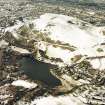
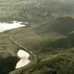
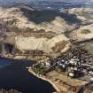
Edinburgh, Holyrood Park, Arthur's Seat


Cultivation Terrace(S) (Medieval)
Site Name Edinburgh, Holyrood Park, Arthur's Seat
Classification Cultivation Terrace(S) (Medieval)
Alternative Name(s) Queen's Park
Canmore ID 52542
Site Number NT27SE 76
NGR NT 27962 72908
NGR Description Centred NT 2796 7290
Datum OSGB36 - NGR
Permalink http://canmore.org.uk/site/52542


- Council Edinburgh, City Of
- Parish Edinburgh (Edinburgh, City Of)
- Former Region Lothian
- Former District City Of Edinburgh
- Former County Midlothian
NT27SE 76 centred 2796 7290
See also NT27SE 135.
(Centred NT 2790 7288) Cultivation Terraces (NR)
OS 6" map, (1966)
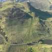
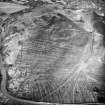
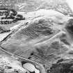
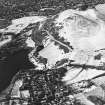
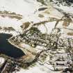
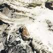
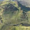
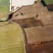
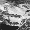
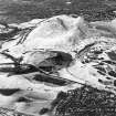
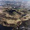
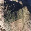
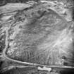
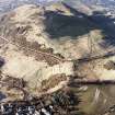
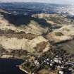
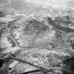
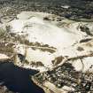
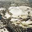
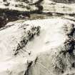
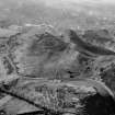
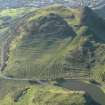
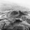
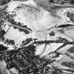
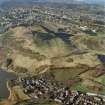
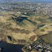
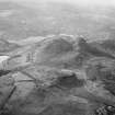
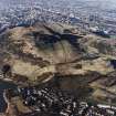
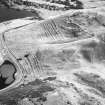
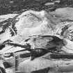
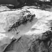
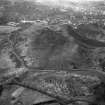
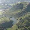
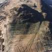
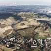
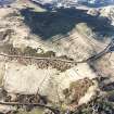
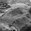
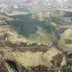
There is a fine group of some thirty cultivation terraces on the E side of Arthur's Seat, above the Queen's Drive. They cross the hillside for a distance of some 730' (223m). Where well-defined, their width varies from 15' - 34' (4.6-10.3m), with scarps from about 2' - 12' (0.6-3.7m) in height. The stone revetments of some of these terraces may still be seen. They have been encroached on by later rig cultivation running uphill. Where the centre rigs impinge on the terraces, a World War I military trench has disturbed the ground.
R B K Stevenson 1949; A Graham 1939; RCAHMS 1929, visited 1928; R Chambers 1855; Visible on RCHME air photograph NT2772/1: flown 1939.
These cultivation terraces are as described in previous information.
Visited by OS (S F S) 3 December 1975.
Field Visit (10 May 1928)
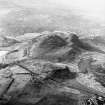
Terraces, Dunsapie.
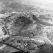
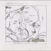
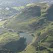
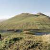
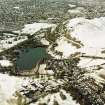
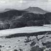
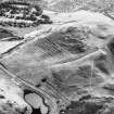
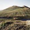
Hill-side terraces formed by cultivation in medieval or earlier times have been identified in many parts of England, but are of comparatively rare occurrence in Scotland. A well-defined series of terraces, apparently of an allied character, exists on the slopes of the hill overlooking Dunsapie Loch on the west (Fig. 101), and a second series, much broken and of lesser extent, still survives on a hollow slope at the base of the same hill, close to the margin of Duddingston Loch. The upper series occurs at an elevation of 450 to 600 feet above sea-level, and, viewed from a distance, shows ten terraces. At close quarters the two uppermost of these become less apparent. The series traverses the hill-side for a distance of approximately 728 feet. Where well defined, the terraces are of a width varying from 15 to 34 feet - with scarps approximately from 2 feet to 12 feet in height. The Duddingston series is more irregular, and, for the most part, the original lines have been destroyed. Only the lower terrace, which shows a width varying from 46 to 53 feet, survives fairly complete, and its construction and general appearance suggest that it is contemporaneous with those on the higher slopes. Unlike certain English examples, the Dunsapie terraces cannot be associated with the open-field system with its statute acres and customary acres, which has been traced back to the early part of the Saxon period. Neither can they meantime be classified with other terrace groups, known as the Celtic type, that have been associated in England with settlements of the Early Iron Age and Roman period. In connection with these English examples we are told ‘it is necessary to realize that such terraces have not been formed intentionally, but are the result of ploughing’ (1). At Dunsapie, however, although other indications point to the existence of an early and extensive settlement in the vicinity, there is the distinctive feature of at least partial construction of the terraces. Here and there, especially in the fifth and sixth terraces of the upper series and in the first and second lines of the lower series, the scarped divisions are still in part marked out by stone facings of crude and irregular construction. The situation of the terraces in close proximity to the fort on Dunsapie Hill (No. 10) and the crannog in Duddingston Loch (p. xxv), naturally suggests a connection with one Or other of these constructions (2), but the association (if, indeed, there is any) can only be satisfactorily determined by excavation.
RCAHMS 1929, visited 10 May 1928.
(1) Antiquity, Vol. I (1927), p. 273.
(2) Cf. Proc. Soc. Ant. Scot., i (1851-4), pp. 129-133.
OS map: iii N.E. (unnoted.)
Publication Account (1951)
211. Cultivation Terraces, King's Park.
Cultivation terraces are to be seen at the following places in the King's Park:
(i) [NT27SE 76, NT27SE 77 and NT27SE 135] On the E. slopes of Arthur's Seat, both above and below the Queen’s Drive. An account of these very striking group has already been published in the Inventory of Midlothian (1).
(ii) [NT27SE 102] To S. and E. of Dunsapie Fort (2) and extending E. of the fort outside the boundary wall of the Park [NT27SE 102]. (iii) [NT27SE 97] Immediately below the southernmost outcrop of the Echoing Rock; only the ends of two narrow terraces appear here, but it is possible that the broad rigs that cover the lower parts of this slope may have obliterated a group perhaps once comparable with those at Dunsapie.
(iv) [NT27SE 27] On the N.E. face of Haggis Knowe. At the bottom of the slope there are three long terraces, and above them some shorter and less well marked terraces and shelves.
RCAHMS 1951, visited c.1941
(1) No. 11. Cf. also P.S.A.S., lxxiii (1938-9), pp.289 ff., and lxxxi (1946-7), pp. 159 ff.
(2) Inventory of Midlothian and West Lothian, No. 10.
OS Map: Midlothian iii N.E. and S.E
Condition Survey (February 1996)
There are twelve well-preserved examples of cultivation terraces and around the same number of less-well preserved examples down slope. They measure between 2m and 3m high and up to 8m wide. Stone boulders are visible in the faces of a number of the terraces especially where paths have been worn up the hill slope. The northern part of the cultivation terraces have previously been described separately under NT27SE 135).
Information from Derek Alexander (Centre for Field Archaeology, University of Edinburgh) February 1997, nos.27 and 30
Alexander 1997
Field Visit (15 December 1998)
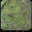
A flight of at least twenty cultivation terraces extends across the eastern slopes of Arthur's Seat, below the ramparts of the fort on Crow Hill (NT27SE 93) and is plotted at 1:5,550 on an archaeological map of Holyrood Park (RCAHMS 1999). The terraces are most impressive on the steeper ground to the N, where they are also at their narrowest, measuring between 7.5m and 9m in breadth and up to 1.8m in height. As they descend the slope, the terraces broaden and become less well-defined, but they can still be traced over a distance of 370m. To the SE, the lower terraces are overlain by a plot of rig-and-furrow cultivation (NT27SE 3968), while the N ends of the uppermost terraces are overlain by the banks of two rectilinear enclosures (NT27SE 3939). No trace was found of the World War 1 trench referred to by Stevenson, and the stone revetments, first described by Chambers, appear to be little more than rough lines of cleared stones and boulders. The terraces appear to be the cumulative result of successive seasons of ploughing along a slope, and those recorded under NT27SE 135 are a continuation of the lower terraces to the N.
Visited by RCAHMS (ARG), 15 December 1998.
NMRS, MS/726/96 (47, no. 27); RCAHMS 1999.
Condition Survey (12 March 2018 - 15 April 2018)
The 2018 survey found the site as per Alexander's 1997 survey but with more pathway erosion.
Information from Graeme Carruthers (CFA Archaeology Ltd) July 2018. OASIS ID: cfaarcha1-317194, 27, 30
(Alexander 1997)

