
Balmuildy


Temporary Camp (Roman)
Site Name Balmuildy
Classification Temporary Camp (Roman)
Alternative Name(s) Buchley
Canmore ID 44479
Site Number NS57SE 15
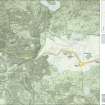
NGR NS 58600 72200
Datum OSGB36 - NGR
Permalink http://canmore.org.uk/site/44479


- Council East Dunbartonshire
- Parish Cadder (Strathkelvin-du)
- Former Region Strathclyde
- Former District Strathkelvin
- Former County Lanarkshire
NS57SE 15 58600 72200
(NS 5860 7220) Roman Camp (R) (site of)
OS 6" map, (1971).
Not to be confused with Balmuildy Roman fort (centred NS 5811 7169), for which see NS57SE 12.
For possible Roman fortlet at East Balmuildy (NS c. 58 71), see NS57SE 28.
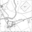
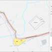
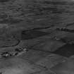
No trace of this Roman camp can be seen on the ground (RCAHMS 1978). Situated in a good position on a shoulder of rising ground to the N of the Antonine Wall and approximately 470m NE of Balmuildy fort (NS57SE 12), it was discovered from the air in 1951. It measures 262m from NE to SW by 186 m transversely, and the positions of the gates, all of which are visible on air photographs, indicate that it faced SW.
Visible on CUCAP air photographs GN 73-81, WC 13, ADY 96 and on RCAHMS APs LA 2027-30.
Visited by OS (E G C) 9 September 1966.
J K S St Joseph 1955; RCAHMS 1978, visited 1975.
Scheduled as 'Antonine Wall, Roman temporary camp 450m W of Buchley Farm... the buried remains of a Roman temporary camp, visible on aerial photographs as the cropmarks of its perimeter ditch... close to the edge of a low rise, [and] spreading across two fields used for pasture and arable cultivation... The camp is approximately 245m NE-SW by 180m transversely, creating an internal area of 4.9 hectares.'
Information from Historic Scotland, scheduling document dated 26 November 2009.
Aerial Photography (11 July 1951)
Aerial Photography (1 August 1957)
Aerial Photography (1957)
Field Visit (9 September 1966)
Visited by OS (E G C) 9 September 1966.
Aerial Photography (27 July 1972)
Aerial Photography (3 August 1974)
Aerial Photography (1974)
Field Visit (1975)
No trace of this Roman camp can be seen on the ground (RCAHMS 1978). Situated in a good position on a shoulder of rising ground to the N of the Antonine Wall and approximately 470m NE of Balmuildy fort (NS57SE 12), it was discovered from the air in 1951. It measures 262m from NE to SW by 186 m transversely, and the positions of the gates, all of which are visible on air photographs, indicate that it faced SW.
Visible on CUCAP air photographs GN 73-81, WC 13, ADY 96 and on RCAHMS APs LA 2027-30.
J K S St Joseph 1955; RCAHMS 1978, visited 1975.
Aerial Photography (21 July 1977)
Aerial Photography (1980)
Note (1982)
Balmuildy, Buchley, Temporary Camp NS 586 722 NS57SE 15
This camp, situated 470m NE of the fort no. 30, on the N side of the Antonine Wall, was identified from cropmarks; it measures 262m by 186m (4.9ha) and there are two small external annexes on the NE and SW sides.
RCAHMS 1982
(RCAHMS 1978, pp. 114-19, No. 248)
Publication Account (2008)
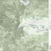
A 1:25000 scale map of the Antonine Wall was published by RCAHMS in 2008. The map shows the course of the Antonine Wall on a modern map base, including areas where the Wall is in public ownership or care and can be visited. The data had been collated as part of the project to prepare maps for the World Heritage Site nomination bid.
Publication Account (17 December 2011)
The camp lies in an arable field to the north of the Antonine Wall, about 500m north of the Roman fort at Balmuildy, in a loop of the River Kelvin east of where the Wall crosses the river. It was first discovered from the air by St Joseph in 1951 (1955: 86).
The camp measures about 257m from north-east to south-west by about 187m transversely, enclosing an area of some 4.7ha (12 acres). Entrance gaps are visible in the centre of south-west and north-east sides, and there are possible gaps in the other two sides. Together these suggest that the camp probably faced south-west towards the nearby fort.
The camp is provided with a small annexe on the eastern half of the north-east side, measuring 71m by 87m and enclosing an additional 0.62 hectares. Unusually, there appears to be a second annexe to the south-east of this, measuring 65m to the south-east by at least 98m, but only parts of the additional north-east and south-east sides have been recorded. The addition of these two annexes increases the entire area enclosed: 4.72ha + 0.62ha + 0.64ha = 5.98ha (14.8 acres).
Only two other camps on the Antonine Wall are known to have been furnished with annexes or attached camps (excepting the Lochlands complex), and the provision of a second annexe is currently unparalleled in Britain.
R H Jones 2011

