
Pricing Change
New pricing for orders of material from this site will come into place shortly. Charges for supply of digital images, digitisation on demand, prints and licensing will be altered.
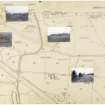
Antonine Wall: Old Kilpatrick - Mount Pleasant - Duntocher


Frontier Defence (Roman)
Site Name Antonine Wall: Old Kilpatrick - Mount Pleasant - Duntocher
Classification Frontier Defence (Roman)
Alternative Name(s) Gavinburn; Carleith; Golden Hill Park; Beeches Avenue; North Dalnottar; Netherclose
Canmore ID 43261
Site Number NS47SE 83
NGR NS 4610 7330
NGR Description NS 4585 7301 to NS 5000 7238
Datum OSGB36 - NGR
Permalink http://canmore.org.uk/site/43261


- Council West Dunbartonshire
- Parish Old Kilpatrick (Clydebank)
- Former Region Strathclyde
- Former District Clydebank
- Former County Dunbartonshire
NS47SE 83.00 4585 7301 to 5000 7239
Formerly entered as Site no. 9999.
For Roman fort at Old Kilpatrick (NS 4600 7315), see NS47SE 8.
For Roman fort at Duntocher (Golden Hill Park), see NS47SE 12.
For continuation to E, see NS57SW 65.00.
Antonine Wall:
NS47SE 83.01 NS 4827 7295 to NS 4832 7293 Antonine Wall; Watching Brief
NS47SE 83.02 NS 4836 7296 Antonine Wall; Watching Brief
NS47SE 83.03 NS c. 490 728 Antonine Wall, Duntocher, St Mary's Primary School; Military Way; Trial Excavation
NS47SE 83.04 NS 4603 7332 to NS 4954 7260 Antonine Wall; Military Way
NS 481 730 The Antonine Ditch, 5.8m wide, was located S of Carleith Farm, 1km W of Duntocher church, on a line S of that previously supposed by Macdonald (1934) and OS (1969).
G Macdonald 1934; Ordnance Survey 1969; D R Wilson 1970.
NS 480 731 to NS 482 730 The Wall was examined 1.5km W of Duntocher fort (NS47SE 12), on the slope down to West Carleith Burn. The stone base, 5.2m wide, had five steps. Near the burn a wall-foundation 2.7m wide joined it is right angles on the S side. Three lines of metalling were observed S of the Wall, at 21m, at 69m and at 108m respectively. The road was unkerbed, 4.6m wide, and divided in to two branches running WNW (parallel to the Wall) and W. The road was seen as a line of heavy bottoming 3.1m - 4.3m wide crossing an area of building debris.
E J Price and J Price 1971; D R Wilson 1972.
NS 4585 7301 to NS 4591 7313 The published survey (OS 50 inch 1965) was revised. There is no recorded information as to the exact termination point of the defences. The line has been projected from the known detail at NS 4591 7315.
NS 4591 7315 Line of Wall, Ditch and fort defences determined by excavations in 1923-4 (Miller 1928) and 1930-1 (Macdonald 1932).
NS 4591 7315 to NS 4600 7326 The published survey (OS 50 inch 1965) was revised. The Ditch and fort (NS47SE 8) defences have been modified upon examination of excavation plans (at NS 4591 7315).
NS 4600 7326 to NS 4634 7335 The published survey (OS 50 inch 1964) was revised. No surface trace across arable fields and housing development. Failing any evidence to the contrary, Macdonald's line has been retained using the location measurements given (see NS 4604 7330 and NS 4609 7332).
NS 4604 7330 The line was established by trenching in 1913 and by excavations at Old Kilpatrick fort (NS47SE 8) in 1931 (Macdonald 1932; 1915).
NS 4609 7332 The line was established by trenching (Macdonald 1915).
NS 4634 7335 to NS 4650 7330 The published survey (OS 50 inch 1964) was revised. No surface trace across arable fields. Macdonald's (1932) line, linking various trenching results, somewhat conflicts with the clear cropmark evidence of the Ditch-line in CUCAP aerial photograph V75. Using Macdonald's measurements with aerial photographs and ground detail the line has been adjusted, introducing a further alignment position compatible with ground contours. A possible marker trench, parallel with the Ditch, shows on above aerial photograph.
NS 4641 7334 The line was established by trenching (Macdonald 1915).
NS 4650 7330 to NS 4700 7314 The published survey (OS 50 inch 1975) was revised. No trace across arable fields. Macdonald's general line has been retained, excepting 1st edition of the OS 2 and a half inch (Dunbarton 1862, sheet 23/5) indications that the course is slightly further S than suggested (see NS 4720 7310 to NS 4794 7304). At NS 4650 7330 it has been slightly adjusted to concur with evidence from CUCAP aerial photograph V75 which clearly shows the Ditch-line as a cropmark (see also NS 4634 7335 to NS 4650 7330), but Eastwards to NS 4675 7317 the line is as Macdonald's.
Alignment position at NS 4675 7317 has been adjusted to conform with an obvious change of slope, but that at NS 4688 7316 is consistent with the vague natural contours. Across this field, inspection of RAF vertical aerial photographs (not referenced) proved entirely negative as did enquiry at Mount Pleasant farm.
NS 4651 7330 The line of the Ditch has been confirmed by trenching (Macdonald 1915).
NS 4658 7327 The line of the Ditch, thought to have caused Wall subsidence in stack yard, has been confirmed by excavation (Macdonald 1915).
NS 4661 7324 The Ditch has been noted to be S of and close to three ash trees in a field at Mount Pleasant (ONB 1860).
NS 4664 7322 Causeway found in the road which runs northwards to Mount Pleasant (ONB 1860).
NS 4689 7316 The Course was laid down after repeated trenching in this field but results are not as reliable as elsewhere. The western or upper half of this field had apparently been leveled, removing not only the stone foundation of the Wall but also much of the Ditch (Macdonald 1915).
NS 4700 7314 to NS 4720 7310 The published survey (OS 25 inch 1967) was revised as per NS 4720 7310 to NS 4794 7304. No trace across open fields and no local reports of Ditch or Wall being exposed during road development at Dalnottar Burn.
NS 4707 7314 No trace of Ditch west of Sandyford. Military Way was said to have been found c1836 when clearing road here (ONB 1860).
NS 4720 7310 to NS 4794 7304 The published survey (OS 25 inch 1967) was revised. The Ditch-line shows no more than a level tract roughly parallel with a farm track, but further W, approaching NS 4720 7310 from the E, a slight hollow is visible together with a distinct dip at a N-S hedgeline. At this point the pecked course on later OS editions slightly differs from that of 1st edition of the OS 2 and a half inch (1862) which shows extant remains. As the vague ground evidence tends to support the 1st edition, the line has been slightly lowered and a further alignment position introduced.
NS c. 4730 7309 In December 1909 deep ploughing was seen to throw up many dressed kerb-stones in this area (Macdonald 1934).
NS 4745 7306 The Wall and Ditch was located by trenching at several points in this area, c. 1913. OS line was confirmed (Macdonald 1915).
NS 4794 7304 to NS 4800 7302 The published survey (OS 25 inch 1967) was revised. The Ditch, with alignment position, is visible in pasture as a depression some 12m wide and 0.5m deep. Line modified from ground and excavation evidence (at NS 4795 7303 and NS 4799 7301).
NS 4795 7303 The Wall was located by excavation in 1971 (broadly corroborated by NS 4799 7301) (Price 1971).
NS 4799 7301 The Wall was located by excavation in 1980 (Keppie and Walker 1980; Information from L J F Keppie 1980).
NS 4800 7302 to NS 4806 7300 The published survey (OS 50 inch 1972) was revised. No surface trace across pasture fields. Modified line based on evidence at NS 4801 7301 and NS 4802 7300 and ground observation of trenches cut in 1980.
NS 4801 7301 Excavations in 1971 located the line of the Rampart in this area (broadly corroborated by NS 4802 7300 (Price 1971).
NS 4802 7300 The course of the Wall and Ditch was determined by excavations in this area in 1980 (Keppie and Walker 1980; Information from L J F Keppie 1980).
NS 4806 7300 to NS 4835 7295 The published survey (OS 50 inch 1962) was revised. No surface trace across pasture fields. Modified line based on evidence at NS 4806 7299, NS 4810 7298 and NS 4830 7296, and ground observation of excavation trenches in 1980.
NS 4806 7299 Excavation in 1971 located the line of the Rampart in this area and also revealed bifurcating roads leading W and WNW, both 15ft wide with no kerbs. Other metalled ways were observed during ploughing including a supposed Military Way by-pass (see NS47SE 83.03) (Price 1971).
NS 4810 7298 The course of the Wall was determined by excavations in this area in 1980 (Keppie and Walker 1980; Information from L J F Keppie 1980).
NS 4830 7296 The Ditch was located by trenching in 1969 (Robertson and Keppie 1980; Information from L J F Keppie 1980).
NS 4835 7295 to NS 4850 7293 The published survey (OS 50 inch 1962) was revised. No surface trace across developed area. Modified line based on examination of extant Ditch survey of 1st edition of the OS 2 and a half inch (Dunbarton 1862, sheet 23/6) and known position of Ditch at NS 4830 7296.
NS 4850 7293 to NS 4900 7291 The published survey (OS 50 inch 1972) was revised. Modified line based on findings at NS 4886 7293 and examination of the extant Ditch survey of the 1st edition of the OS 2 and a half inch (Dunbarton 1862, sheet 23/6). A vague hollow of the Ditch was seen in 1957 along Beeches Avenue, mainly as a scarp 1.5m high on the S side (Information from OS 1957), is no longer discernible.
NS 4878 7295 The Ditch is visible E of Auchentoshan (Horsley 1732; Gordon 1726).
NS 4863 7297 A series of trenches were cut in 1955 to test Macdonald's line (see NS 4896 7297) proved negative (Robertson 1966).
NS 4886 7293 Trenches cut in 1957 located the Ditch and its alignment (Robertson 1966).
NS 4896 7297 Macdonald's line, as a result of trenching in 1913, is well north of Beeches Road and has a sharp angle at this point. (Line now refuted - see NS 4878 7295 and NS 4886 7293) (Macdonald 1915).
NS 4900 7291 to NS 4923 7287 The published survey (OS 50 inch 1970) was revised. No surface trace across developed area. As Macdonald's (1934) course at NS 4912 7294 was refuted by excavations in 1957 (see NS 4863 7297 and NS 4896 7297), the published line is based on the now proven 1st edition of the OS 2 and a half inch. This indicates the course W of Farm Road, but to the E it has now been modified to conform more readily with the ground contours; the direction change of Beeches Road at this point is probably significant.
NS 4912 7294 Macdonald states that the line of the Ditch was located, mainly utilizing a natural gully, and that the Wall kerbing was located by trenching (no measurements given) (Macdonald 1915).
NS 4923 7287 to NS 4950 7273 The published survey (OS 50 inch 1970) was revised. No surface trace across largely developed area. The modified line was based on projected detail of the 1st edition of the OS 2 and a half inch (Dunbarton 1862, sheet 23/6) which shows the Ditch as extant westwards to Duntocher Burn. An alignment change could be expected at the Burn, but the general contours suggest no deviation until the naturally prominent position at NS 4923 7287.
NS 4931 7283 Here the line becomes conjectural, for digging was?impractical (Macdonald 1915).
NS 4946 7275 The Wall base with a culvert was exposed to view (presumably as a result of 1948-51 excavations see NS47SE 12) (Robertson 1957, 1973).
NS 4947 7276 The Ditch is visible down slope (Macdonald 1934).
NS 4950 7273 to NS 4959 7265 The published survey (OS 50 inch 1970) was revised. A 15m length of the Outer Ditch is preserved in parkland at the extreme NW corner of the fort defences (see NS47SE 12). It is 4.5m wide and 0.5m deep, with a slight inner bank. A vague hollow marks the line of the main ditch in front of the fort and fortlet sites; it is shown as extant on the 1st edition of the OS 2 and a half inch (Dunbarton 1862, sheet 23/6) and the 2nd edition of the OS 2 and a half inch (Dunbarton 1899, sheet 23/6). The course was adjusted to accord with the excavated findings at NS 4956 7267.
NS 4956 7267 The course of the Wall and Ditch were determined during fort excavations in 1948 and 1949-51 (Robertson 1957, 1979).
NS 4959 7265 to NS 5000 7239 The published survey (OS 50 inch 1972) was revised. No surface trace across housing development. The course and alignment angles were adjusted to accord with findings at NS 4969 7256, excavation plans at (NS 4985 7246 and the partially extant line as shown on the 1st edition of the OS 2 and a half inch (Dunbarton 1862, sheet 23/11) and the 2nd edition of the OS 2 and a half inch (Dunbarton 1899, sheet 23/11) and subsequent plans. The general course and alignment points are indicated on the 1st and 2nd edition of the OS 2 and a half inch.
NS 4969 7256 The course of the Wall and Ditch were determined by excavation in 1947 (Robertson 1957, 1979).
NS 4971 7256 and NS 4995 7246 The impress of the Ditch is visible under favourable conditions (Macdonald 1934).
NS 4985 7246 The course if the Wall and Ditch were found by excavation in 1947 (Robertson 1957, 1979).
Information from OS 1980
A Gordon 1726; J Horsley 1732; L J F Keppie and J Walker 1980; G Macdonald 1915, 1932, 1934; S N Miller 1928; ONB 1860; E J Price 1971; A S Robertson 1957, 1966, 1973, 1979
NS47SE 52 480 729.
NS 480 730 - NS 482 730 (NS 479 730 - NS 481 729 ?) Excavations at Carleith in 1980 to prove the line of the Antonine Wall also sought evidence of a possible fortlet which on the grounds of spacing might be expected hereabouts. Search for a fortlet was concentrated at three points:
(i) on high ground in front of Carleith farm (area NS 4813 7296);
(ii) where the Wall turns northwards (area NS 4805 7298), and
(iii) on lower ground beside the Carleith Burn where enigmatic structures, including "a wall base 9ft wide which leaves at 90 degrees to the southern edge of the Antonine Wall", were observed in 1971 (area NS 4796 7300).
Further work at (i), the most likely position, where fragments of the stone base on two apparently conflicting alignments were located, is in prospect.
L Keppie and J Walker 1980; MS and oral information from L Keppie and J Walker, May 1980.
NS 480 730 to NS 482 730 The Wall was checked for 200m, confirming the double change in alignment shown on the OS maps, but no trace was found of the fortlet which, on grounds of spacing, might be expected in this position; the most likely site had, however, been disturbed by quarrying and ploughing.
L J F Keppie and J J Walker 1980; F O Grew 1981.
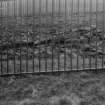
In July 1987 a gas pipeline crossed the presumed line of the Roman frontier at two points E of Old Kilpatrick Fort. At NS 470 731, beside the gas governor, the ground had been much disturbed, and no archaeological layers were observed. At NS 463 734, beside the A82 boulevard, the results were similarly negative, probably because the ground had already been cut away to secure a level terrace for the A82. The alignment of the Antonine ditch is visible as a hollow N of the boulevard. There were no small finds.
L J F Keppie and N Curtis 1987.
NS 4590 7314 In August and September 1994, GUARD carried out an excavation in advance of a proposed extension of the existing bus washing facility. The area coincided, based on Miller's (Miller 1928) fort plan (see NS47SE 8), with an area just outside the fort defences, at its western corner and at a point where there is a break in the line of the triple ditches fronting the fort. Fifteen small trenches were opened within the area of which five produced archaeologically significant remains. Several post-holes and a feature with the character and appearance of a Roman road and was similar to the pre-Wall road described by Miller (1928) were revealed. The nature of the investigation, involving the opening of numerous small, discrete keyhole trenches, precludes the identification of anything.
In July 1999, AOC Archaeology Ltd maintained a watching brief while engineering contractors cut two site investigation trenches through the concrete slab of the depot forecourt and a further five small test pits through the floor of the standing bus garage building. Trench 1 (at NS 4595 7322) and 2 (at NS 4596 7324) revealed three ditches that formed the western fore-works to the combined Roman fort and Antonine Wall defences.
The identification the ditches repeats observations by earlier investigator on the sites and confirms the survival of the truncated, combined fort and Wall defences in almost exactly the same situation and alignment separately by Macdonald (1932) and Miller (1928). It should be noted, however, that none of these features resembled the classic Roman V-shaped ditch profile.
S N Miller 1928; G MacDonald 1932; A Dunwell, G Bailey, A Leslie, A Smith 2002; K Speller and A Leslie 2002.
The following lengths of the Antonine Wall within this map sheet have been accorded statutory protection by Scheduling:
NS 4606 7330 to NS 4624 7333. Railway to Great Western Road, Old Kilpatrick. (no. 7063).
NS 4665 7320 to NS 4705 7313. Mount Pleasant to Mount Pleasant Gas Governor. (no. 7074).
NS 4707 7313 to NS 4753 7304. Mount Pleasant Gas Governor to WNW of North Dalnottar Cemetery. (no. 7065).
NS 4753 7305 to NS 4802 7300. North of North Dalnottar Cemetery. (no. 7066).
NS 4802 7301 to NS 4834 7295. SW of Carleith to N of Carleith Primary School. (no. 7074).
NS 4850 7295 to NS 4872 7293. Beeches Avenue. (no. 7160).
NS 4940 7278 to NS 4960 7264. Golden Hill Park. (no. 7070).
Information from Historic Scotland (all scheduling orders dated 2 February 1999).
(Formerly described under NS47SE 83.01)
NS 4827 7295 to NS 4832 7293 In November 1996, GUARD conducted a watching brief on the excavation of post-holes for a new perimeter fence at Carleith Primary School. Part of this fence ran along the edge of the scheduled area containing the course of the Antonine Wall. There were no archaeological remains encountered that could definitely be associated with the Antonine Wall and the evidence from the post-holes suggests that the area under investigation has been substantially disturbed.
Sponsor: West Dunbartonshire Council.
D Abernethy 1997.
(Formerly described under NS47SE 83.02)
NS 4836 7296 A watching brief was carried out by WoSAS during excavation of foundation trenches for an extension to the rear of 170 Beeches Road, Duntocher, just N of the line of the Antonine Wall. No pre-modern features or structures were identified in trenches c 0.45m deep.
West of Scotland Archaeology Service 1997.
(Formerly described under NS47SE 239) NS 494 728
An archaeological evaluation was undertaken in November 2004 as the line of the Antonine Wall and its associated ditch might cross the SW edge of the site. The Roman fort of Golden Hill Park and its related bathhouse lie directly to the S. A total of 64m2 was investigated by means of evaluation trenches, though test pits were necessary in most areas to reach natural alluvial deposits. Modern made ground was identified to the S of the site, while made ground of 20th-century date and redeposited natural alluvial deposits associated with the burn were revealed in the N and E. No significant archaeological features or deposits were encountered. See also NS47SE 6.
Archive to be deposited in the NMRS.
Sponsor: Stuart McElney.
M Roy 2004.
[NS 46664 73220 to NS 47044 73135]. Length scheduled as 'Antonine Wall, Mount Pleasant, 190m WSW to 215m SSE of Netherclose...' (Scheduling number 7064).
Information from Historic Scotland, scheduling document dated 26 November 2009.
(Index no. 6836: extends onto map sheet NS57Sw). The length of the Antonine Wall from 950m W to 335m ENE of Cleddens [Cleddans] is Scheduled. This length survives mainly as buried remains, and includes the site of a fortlet. Traces of the ditch survive immediately E of the buildings of Cleddens [Cleddans] Farm.
[The attached map indicates that the Scheduled length extends from NS 4987 7229 to NS 5139 7231].
Information from Historic Scotland, scheduling document dated 30 March 2010.
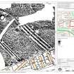
Features associated with the Antonine Wall (NS47SE 83) and the Antonine period fortlet, fort and annexe (NS47SE 12) have been identified in gradiometer data captured within Golden Hill Park.
The line of the Antonine Wall (NS47SE 83) follows that depicted on the 2022 edition of the digital OS MasterMap, running from NW to SE though Golden Hill Park. In the NW of the park the ditch has been recorded as a single linear negative anomaly 4.3m across. This splits into three ditches at the N corner of the annexe of Duntocher fort (NS47SE 12). This triple-ditch system extends for a distance of 139m to the S boundary of the park. The outer (NE) ditch measures 3m across, the central ditch 3m and the inner ditch 4.1m. The ditches are separated by berms 4.1m across. Causeways are visible across all three ditches.
Some 6.3m SW of the inner ditch a pair of narrow negative linear trends, set 5.5m apart, run parallel with the Antonine ditches. This conforms to the expected width of the Antonine Wall rampart base and so can be interpreted as surviving elements of the rampart. A series of discrete positive anomalies recorded on the berm between the inner ditch and the rampart may represent defensive pits called cippi.
The fortlet, fort and annexe (NS47SE 12) abut the Antonine Wall triple-ditch system (NS47SE 83). The fortlet (NS 49579 72684) is considered to pre-date the fort and annexe. It is visible as a square enclosure formed by a weak linear trend, representing the outer ditch of the fortlet, surrounding a 5.5m broad band of dipolar anomalies enclosing an area measuring 15.9m across. This response is caused by the buried rampart base. A series of positive linear anomalies within the fortlet appear to align with the ramparts and may relate to internal structures.
The NE defences of the fort and annexe are formed by the triple-ditch system of the Antonine Wall (NS27SE 83) described above, while the ditches of the SW defences have been recorded as three negative linear responses some 55m to the SW. The inner (NE) ditch of the SW defences measures 2.7m across, the central ditch 2.1m and the outer ditch 3m. No causeways across the ditches can be identified. The SE rampart has been partially detected at the S extent of the park as a negative linear anomaly 8.6m in length and extending from NE to SW from the NE rampart of the fort. The NW defences have not been detected.
The enclosed area is divided into fort and annexe by a rampart represented by a pair of weak negative linear trends. These trends extend from SW to NE from the S ditches of the fort towards the S corner of the fortlet. There are a small number of discrete positive anomalies visible between the linear trends, probably representing stones forming the base of the rampart.
What may be the remains of buildings have been recorded within both the fort and annexe. Within the SW section of the fort, negative and positive linear trends interspersed with discrete positive anomalies form a broadly rectangular pattern measuring 24m from NE to SW by 7m. These correspond with the location of a building identified during excavations in the 1950s (Robertson 1957: 14 & 15 figure 4) and may relate to the remains of this building, although they could also be an artefact of the excavation process. Similar negative and positive linear trends within the SW section of the annexe share a similar alignment and may also represent the remains of buildings.
Information from HES Archaeological Survey (N. Hannon), 22 June 2022.
Features associated with the Antonine Wall (NS47SE 83) and the Antonine period fortlet, (NS47SE 52) have been identified in gradiometer data captured at Carleith Farm.
The line of the Antonine Wall (NS47SE 83) follows that depicted on the 2022 edition of the digital OS MasterMap, running from E to W though through the amenity land N of Carleith Primary School and turning to the NW as it passes to the S of Carleith Farm. This supports the results of earlier excavation (Keppie & Breeze 1981: 242). The ditch has been recorded as a single linear negative anomaly measuring 7m across. It is visible in the E of the survey area but is difficult to identify with certainty towards the W due to magnetic disturbance. Fragmentary traces of the Rampart base are visible in the extreme S of the survey area, and parts of the Outer Mound are visible to the N of and parallel with the Ditch.
Two linear features of raised magnetism projecting at right angles from the line of the rampart of the Antonine Wall represent the remains of the fortlet (NS47SE 52). It is located immediately W of the excavations undertaken in the 1980s (Keppie & Breeze 1981) and measures about 20m from NNW to SSE within ramparts about 3m thick. Its N to S dimensions could not be confirmed. No defensive ditches associated with the fortlet were identified in the survey data, so it cannot be established if the fortlet had a freestanding phase.
.
Information from HES Archaeological Survey (N. Hannon), 14 June 2022.
Antiquarian Observation (1732)
NS 4878 7295 The Ditch is visible E of Auchentoshan (Horsley 1732; Gordon 1726).
Antiquarian Observation (1860)
NS 4661 7324 The Ditch has been noted to be S of and close to three ash trees in a field at Mount Pleasant (ONB 1860).
Antiquarian Observation (1860)
NS 4707 7314 No trace of Ditch west of Sandyford. Military Way was said to have been found c1836 when clearing road here (ONB 1860).
Antiquarian Observation (1860)
NS 4664 7322 Causeway found in the road which runs northwards to Mount Pleasant (ONB 1860).
Salvage Record (1909)
NS c. 4730 7309 In December 1909 deep ploughing was seen to throw up many dressed kerb-stones in this area (Macdonald 1934).
Trial Trench (1913)
NS 4604 7330 The line was established by trenching in 1913 at Old Kilpatrick fort (NS47SE 8) (Macdonald 1915).
Trial Trench (1913)
NS 4896 7297 Macdonald's line, as a result of trenching in 1913, is well north of Beeches Road and has a sharp angle at this point. (Line now refuted - see NS 4878 7295 and NS 4886 7293) (Macdonald 1915).
Trial Trench (1913)
NS 4745 7306 The Wall and Ditch was located by trenching at several points in this area, c. 1913. OS line was confirmed (Macdonald 1915).
Trial Trench (1915)
NS 4609 7332 The line was established by trenching (Macdonald 1915).
Field Visit (1915)
NS 4931 7283 Here the line becomes conjectural, for digging was impractical (Macdonald 1915).
Trial Trench (1915)
NS 4912 7294 Macdonald states that the line of the Ditch was located, mainly utilizing a natural gully, and that the Wall kerbing was located by trenching (no measurements given) (Macdonald 1915).
Trial Trench (1915)
NS 4689 7316 The Course was laid down after repeated trenching in this field but results are not as reliable as elsewhere. The western or upper half of this field had apparently been leveled, removing not only the stone foundation of the Wall but also much of the Ditch (Macdonald 1915).
Excavation (1915)
NS 4658 7327 The line of the Ditch, thought to have caused Wall subsidence in stack yard, has been confirmed by excavation (Macdonald 1915).
Trial Trench (1915)
NS 4651 7330 The line of the Ditch has been confirmed by trenching (Macdonald 1915).
Trial Trench (1915)
NS 4641 7334 The line was established by trenching (Macdonald 1915).
Excavation (1923 - 1924)
NS 4591 7315 Line of Wall, Ditch and fort defences determined by excavations in 1923-4 (Miller 1928).
Excavation (1930 - 1931)
NS 4591 7315 Line of Wall, Ditch and fort defences determined by excavations in 1930-1 (Macdonald 1932).
Excavation (1931)
NS 4604 7330 The line was established by excavations at Old Kilpatrick fort (NS47SE 8) in 1931 (Macdonald 1932).
Field Visit (1934)
NS 4971 7256 and NS 4995 7246 The impress of the Ditch is visible under favourable conditions (Macdonald 1934).
Excavation (1947)
NS 4969 7256 The course of the Wall and Ditch were determined by excavation in 1947 (Robertson 1957, 1979).
Excavation (1947)
NS 4985 7246 The course of the Wall and Ditch were found by excavation in 1947 (Robertson 1957, 1979).
Excavation (1948 - 1951)
NS 4946 7275 The Wall base with a culvert was exposed to view (presumably as a result of 1948-51 excavations see NS47SE 12) (Robertson 1957, 1973).
Excavation (1948 - 1951)
NS 4956 7267 The course of the Wall and Ditch were determined during fort excavations in 1948 and 1949-51 (Robertson 1957, 1979).
Trial Trench (May 1955)
NS 4863 7297 A series of trenches were cut in 1955 to test Macdonald's line (see NS 4896 7297) proved negative (Robertson 1966).
Trial Trench (April 1957)
NS 4886 7293 Trenches cut in 1957 located the Ditch and its alignment (Robertson 1966).
Field Visit (1957)
NS 4850 7293 to NS 4900 7291 The published survey (OS 50 inch 1972) was revised. Modified line based on findings at NS 4886 7293 and examination of the extant Ditch survey of the 1st edition of the OS 2 and a half inch (Dunbarton 1862, sheet 23/6). A vague hollow of the Ditch was seen in 1957 along Beeches Avenue, mainly as a scarp 1.5m high on the S side (Information from OS 1957), is no longer discernible.
Excavation (1957)
NS 4900 7291 to NS 4923 7287 The published survey (OS 50 inch 1970) was revised. No surface trace across developed area. As Macdonald's (1934) course at NS 4912 7294 was refuted by excavations in 1957 (see NS 4863 7297 and NS 4896 7297), the published line is based on the now proven 1st edition of the OS 2 and a half inch. This indicates the course W of Farm Road, but to the E it has now been modified to conform more readily with the ground contours; the direction change of Beeches Road at this point is probably significant.
Trial Trench (May 1969)
NS 4830 7296 The Ditch was located by trenching in 1969 (Robertson and Keppie 1980; Information from L J F Keppie 1980).
Trial Trench (May 1969)
NS 4830 7296 The Ditch was located by trenching in 1969 (Robertson and Keppie 1980; Information from L J F Keppie 1980).
Field Visit (1969)
NS 481 730 The Antonine Ditch, 5.8m wide, was located S of Carleith Farm, 1km W of Duntocher church, on a line S of that previously supposed by Macdonald (1934) and OS (1969).
G Macdonald 1934; Ordnance Survey 1969; D R Wilson 1970.
Salvage Record (1971)
NS 480 731 to NS 482 730 The Wall was examined 1.5km W of Duntocher fort (NS47SE 12), on the slope down to West Carleith Burn. The stone base, 5.2m wide, had five steps. Near the burn a wall-foundation 2.7m wide joined it is right angles on the S side. Three lines of metalling were observed S of the Wall, at 21m, at 69m and at 108m respectively. The road was unkerbed, 4.6m wide, and divided in to two branches running WNW (parallel to the Wall) and W. The road was seen as a line of heavy bottoming 3.1m - 4.3m wide crossing an area of building debris.
E J Price and J Price 1971; D R Wilson 1972.
Excavation (1971)
NS 4806 7299 Excavation in 1971 located the line of the Rampart in this area and also revealed bifurcating roads leading W and WNW, both 15ft wide with no kerbs. Other metalled ways were observed during ploughing including a supposed Military Way by-pass (see NS47SE 83.03) (Price 1971).
Excavation (1971)
NS 4801 7301 Excavations in 1971 located the line of the Rampart in this area (broadly corroborated by NS 4802 7300 (Price 1971).
Excavation (1971)
NS 4795 7303 The Wall was located by excavation in 1971 (broadly corroborated by NS 4799 7301) (Price 1971).
Field Visit (1980)
NS 4585 7301 to NS 4591 7313 The published survey (OS 50 inch 1965) was revised. There is no recorded information as to the exact termination point of the defences. The line has been projected from the known detail at NS 4591 7315.
Information from OS 1980
Excavation (1980)
NS47SE 52 480 729.
NS 480 730 - NS 482 730 (NS 479 730 - NS 481 729 ?) Excavations at Carleith in 1980 to prove the line of the Antonine Wall also sought evidence of a possible fortlet which on the grounds of spacing might be expected hereabouts. Search for a fortlet was concentrated at three points:
(i) on high ground in front of Carleith farm (area NS 4813 7296);
(ii) where the Wall turns northwards (area NS 4805 7298), and
(iii) on lower ground beside the Carleith Burn where enigmatic structures, including "a wall base 9ft wide which leaves at 90 degrees to the southern edge of the Antonine Wall", were observed in 1971 (area NS 4796 7300).
Further work at (i), the most likely position, where fragments of the stone base on two apparently conflicting alignments were located, is in prospect.
L Keppie and J Walker 1980; MS and oral information from L Keppie and J Walker, May 1980.
Field Visit (1980)
NS 4959 7265 to NS 5000 7239 The published survey (OS 50 inch 1972) was revised. No surface trace across housing development. The course and alignment angles were adjusted to accord with findings at NS 4969 7256, excavation plans at (NS 4985 7246 and the partially extant line as shown on the 1st edition of the OS 2 and a half inch (Dunbarton 1862, sheet 23/11) and the 2nd edition of the OS 2 and a half inch (Dunbarton 1899, sheet 23/11) and subsequent plans. The general course and alignment points are indicated on the 1st and 2nd edition of the OS 2 and a half inch.
Information from OS 1980
Field Visit (1980)
NS 4950 7273 to NS 4959 7265 The published survey (OS 50 inch 1970) was revised. A 15m length of the Outer Ditch is preserved in parkland at the extreme NW corner of the fort defences (see NS47SE 12). It is 4.5m wide and 0.5m deep, with a slight inner bank. A vague hollow marks the line of the main ditch in front of the fort and fortlet sites; it is shown as extant on the 1st edition of the OS 2 and a half inch (Dunbarton 1862, sheet 23/6) and the 2nd edition of the OS 2 and a half inch (Dunbarton 1899, sheet 23/6). The course was adjusted to accord with the excavated findings at NS 4956 7267.
Field Visit (1980)
NS 4923 7287 to NS 4950 7273 The published survey (OS 50 inch 1970) was revised. No surface trace across largely developed area. The modified line was based on projected detail of the 1st edition of the OS 2 and a half inch (Dunbarton 1862, sheet 23/6) which shows the Ditch as extant westwards to Duntocher Burn. An alignment change could be expected at the Burn, but the general contours suggest no deviation until the naturally prominent position at NS 4923 7287.
Information from OS 1980
Field Visit (1980)
NS 4835 7295 to NS 4850 7293 The published survey (OS 50 inch 1962) was revised. No surface trace across developed area. Modified line based on examination of extant Ditch survey of 1st edition of the OS 2 and a half inch (Dunbarton 1862, sheet 23/6) and known position of Ditch at NS 4830 7296.
Information from OS 1980
Excavation (1980)
NS 4810 7298 The course of the Wall was determined by excavations in this area in 1980 (Keppie and Walker 1980; Information from L J F Keppie 1980).
Excavation (1980)
NS 4806 7300 to NS 4835 7295 The published survey (OS 50 inch 1962) was revised. No surface trace across pasture fields. Modified line based on evidence at NS 4806 7299, NS 4810 7298 and NS 4830 7296, and ground observation of excavation trenches in 1980.
Information from OS 1980
Excavation (1980)
NS 4802 7300 The course of the Wall and Ditch was determined by excavations in this area in 1980 (Keppie and Walker 1980; Information from L J F Keppie 1980).
Trial Trench (1980)
NS 4800 7302 to NS 4806 7300 The published survey (OS 50 inch 1972) was revised. No surface trace across pasture fields. Modified line based on evidence at NS 4801 7301 and NS 4802 7300 and ground observation of trenches cut in 1980.
Information from OS 1980
Excavation (1980)
NS 4799 7301 The Wall was located by excavation in 1980 (Keppie and Walker 1980; Information from L J F Keppie 1980).
Excavation (1980)
NS 4794 7304 to NS 4800 7302 The published survey (OS 25 inch 1967) was revised. The Ditch, with alignment position, is visible in pasture as a depression some 12m wide and 0.5m deep. Line modified from ground and excavation evidence (at NS 4795 7303 and NS 4799 7301).
Information from OS 1980
Field Visit (1980)
NS 4720 7310 to NS 4794 7304 The published survey (OS 25 inch 1967) was revised. The Ditch-line shows no more than a level tract roughly parallel with a farm track, but further W, approaching NS 4720 7310 from the E, a slight hollow is visible together with a distinct dip at a N-S hedgeline. At this point the pecked course on later OS editions slightly differs from that of 1st edition of the OS 2 and a half inch (1862) which shows extant remains. As the vague ground evidence tends to support the 1st edition, the line has been slightly lowered and a further alignment position introduced.
Information from OS 1980
Salvage Record (1980)
NS 4700 7314 to NS 4720 7310 The published survey (OS 25 inch 1967) was revised as per NS 4720 7310 to NS 4794 7304. No trace across open fields and no local reports of Ditch or Wall being exposed during road development at Dalnottar Burn.
Information from OS 1980
Aerial Photographic Interpretation (1980)
NS 4650 7330 to NS 4700 7314 The published survey (OS 50 inch 1975) was revised. No trace across arable fields. Macdonald's general line has been retained, excepting 1st edition of the OS 2 and a half inch (Dunbarton 1862, sheet 23/5) indications that the course is slightly further S than suggested (see NS 4720 7310 to NS 4794 7304). At NS 4650 7330 it has been slightly adjusted to concur with evidence from CUCAP aerial photograph V75 which clearly shows the Ditch-line as a cropmark (see also NS 4634 7335 to NS 4650 7330), but Eastwards to NS 4675 7317 the line is as Macdonald's.
Alignment position at NS 4675 7317 has been adjusted to conform with an obvious change of slope, but that at NS 4688 7316 is consistent with the vague natural contours. Across this field, inspection of RAF vertical aerial photographs (not referenced) proved entirely negative as did enquiry at Mount Pleasant farm.
Information from OS 1980
Field Visit (1980)
NS 480 730 to NS 482 730 The Wall was checked for 200m, confirming the double change in alignment shown on the OS maps, but no trace was found of the fortlet which, on grounds of spacing, might be expected in this position; the most likely site had, however, been disturbed by quarrying and ploughing.
L J F Keppie and J J Walker 1980; F O Grew 1981.
Aerial Photographic Interpretation (1980)
NS 4634 7335 to NS 4650 7330 The published survey (OS 50 inch 1964) was revised. No surface trace across arable fields. Macdonald's (1932) line, linking various trenching results, somewhat conflicts with the clear cropmark evidence of the Ditch-line in CUCAP aerial photograph V75. Using Macdonald's measurements with aerial photographs and ground detail the line has been adjusted, introducing a further alignment position compatible with ground contours. A possible marker trench, parallel with the Ditch, shows on above aerial photograph.
Field Visit (1980)
NS 4600 7326 to NS 4634 7335 The published survey (OS 50 inch 1964) was revised. No surface trace across arable fields and housing development. Failing any evidence to the contrary, Macdonald's line has been retained using the location measurements given (see NS 4604 7330 and NS 4609 7332).
Information from OS 1980
Field Visit (1980)
NS 4591 7315 to NS 4600 7326 The published survey (OS 50 inch 1965) was revised. The Ditch and fort (NS47SE 8) defences have been modified upon examination of excavation plans (at NS 4591 7315).
Information from OS 1980
Salvage Record (July 1987)
In July 1987 a gas pipeline crossed the presumed line of the Roman frontier at two points E of Old Kilpatrick Fort. At NS 470 731, beside the gas governor, the ground had been much disturbed, and no archaeological layers were observed. At NS 463 734, beside the A82 boulevard, the results were similarly negative, probably because the ground had already been cut away to secure a level terrace for the A82. The alignment of the Antonine ditch is visible as a hollow N of the boulevard. There were no small finds.
L J F Keppie and N Curtis 1987.
Excavation (29 August 1994 - 3 September 1994)
NS 460 731. During August 1994, GUARD carried out excavations at the site of a proposed extension to a bus-wash facility at the Gavinburn Bus Depot, Old Kilpatrick. The site was known to overlay the Roman fort. It was anticipated that the extension might impinge on the ditches and possible road line outside the SW corner of the fort. The areas excavated were to be sites of concrete foundations and associated drainage works. A total of fifteen small trenches were opened within an overall area of 16m by 7m.
Of the areas investigated, five revealed archaeological remains and none of the features recorded in any one trench appeared to relate to those in any of the other trenches. No evidence for the fort ditches was uncovered, placing the excavations between a break in the defences. Various discrete features, mostly structural in form were recorded along with two substantial rough stone spreads aligned E-W. One trench revealed the remains of a probable road surface.
It was thought that construction of the bus depot may have disturbed the underlying remains, but all archaeological deposits were well protected by a thick overburden of ploughsoil, itself highly compacted by vehicles.
Sponsor: Kelvin Central Buses.
K Speller 1994c.
Watching Brief (August 1994 - September 1994)
NS 4590 7314 In August and September 1994, GUARD carried out an excavation in advance of a proposed extension of the existing bus washing facility. The area coincided, based on Miller's (Miller 1928) fort plan (see NS47SE 8), with an area just outside the fort defences, at its western corner and at a point where there is a break in the line of the triple ditches fronting the fort. Fifteen small trenches were opened within the area of which five produced archaeologically significant remains. Several post-holes and a feature with the character and appearance of a Roman road and was similar to the pre-Wall road described by Miller (1928) were revealed. The nature of the investigation, involving the opening of numerous small, discrete keyhole trenches, precludes the identification of anything.
Watching Brief (1 November 1996)
NS 4827 7295 to NS 4832 7293 In November 1996, GUARD conducted a watching brief on the excavation of post-holes for a new perimeter fence at Carleith Primary School. Part of this fence ran along the edge of the scheduled area containing the course of the Antonine Wall. There were no archaeological remains encountered that could definitely be associated with the Antonine Wall and the evidence from the post-holes suggests that the area under investigation has been substantially disturbed.
Sponsor: West Dunbartonshire Council.
D Abernethy 1997.
Watching Brief (1997)
NS 4836 7296 A watching brief was carried out by WoSAS during excavation of foundation trenches for an extension to the rear of 170 Beeches Road, Duntocher, just N of the line of the Antonine Wall. No pre-modern features or structures were identified in trenches c 0.45m deep.
West of Scotland Archaeology Service 1997.
Watching Brief (July 1999)
In July 1999, AOC Archaeology Ltd maintained a watching brief while engineering contractors cut two site investigation trenches through the concrete slab of the depot forecourt and a further five small test pits through the floor of the standing bus garage building. Trench 1 (at NS 4595 7322) and 2 (at NS 4596 7324) revealed three ditches that formed the western fore-works to the combined Roman fort and Antonine Wall defences.
The identification the ditches repeats observations by earlier investigator on the sites and confirms the survival of the truncated, combined fort and Wall defences in almost exactly the same situation and alignment separately by Macdonald (1932) and Miller (1928). It should be noted, however, that none of these features resembled the classic Roman V-shaped ditch profile.
S N Miller 1928; G MacDonald 1932; A Dunwell, G Bailey, A Leslie, A Smith 2002; K Speller and A Leslie 2002.
Watching Brief (30 March 2000 - 31 March 2000)
Report - Archaeological watching brief on Roman Road, Duntocher, 2000.
Baker, F.
Excavation (2000)
Plans and location maps of excavation trench, St. Mary's Primary School, Duntocher, 2000.
Baker, F.
Watching Brief (10 April 2001 - 11 April 2001)
NS 4615 7325
A watching brief was carried out over foundation excavations for an extension to a house just NE of the Roman fort. No archaeological deposits or artefacts were observed.
T Addyman 2001
Watching Brief (21 February 2002)
Report - Archaeological watching brief at Duntocher Primary School, Clydebank, 2002.
Sproat, D.
Archaeological Evaluation (28 February 2003)
NS47SE 238 NS 4994 7242
An evaluation was undertaken in February 2003 of two previously excavated foundation trenches on the N side of Golden Hill Nursery, 13 Gavins Road, Hardgate. The site lies on the line of the Antonine Wall/vallum/road and the nursery building was located on an artificial terrace. The area is dominated by 20th-century service trenches and construction-related deposits. A cobble-filled field drain running N-S and a buried ground surface directly on the natural boulder clay horizon were the only two features of interest. No Roman artefacts or archaeological remains were found.
Report lodged with WoSAS SMR.
Sponsors: Mr & Mrs G Johnston.
F Baker 2004
Trial Trench (November 2004)
NS47SE 239 NS 494 728
An archaeological evaluation was undertaken in November 2004 as the line of the Antonine Wall and its associated ditch might cross the SW edge of the site. The Roman fort of Golden Hill Park and its related bathhouse lie directly to the S. A total of 64m2 was investigated by means of evaluation trenches, though test pits were necessary in most areas to reach natural alluvial deposits. Modern made ground was identified to the S of the site, while made ground of 20th-century date and redeposited natural alluvial deposits associated with the burn were revealed in the N and E. No significant archaeological features or deposits were encountered. See also NS47SE 6.
Archive to be deposited in the NMRS.
Sponsor: Stuart McElney.
M Roy 2004
Watching Brief (2 November 2004 - 11 November 2004)
NS 4940 7273 A watching brief was required in November 2004 during the construction of an access ramp and underpinning of the tower at Duntocher Trinity Church (NS47SE 171), as the church lies adjacent to the site of a Roman fort and fortlet. No archaeologically significant features or artefacts were identified.
Archive to be deposited in the NMRS.
Sponsor: Duntocher Trinity Parish Church.
Martin Cook 2004
Watching Brief (9 August 2010)
NS 461 732
A watching brief was carried out on 9 August 2010 during the excavation of foundation trenches for a house extension. Five sherds of 2nd-century AD Roman pottery were recovered from a disturbed context, which also contained more
modern finds. Similar pottery was recovered from the nearby Old Kilpatrick Roman fort when it was excavated in 1928, and it is probable that the pottery originally came from that site.
Archive: RCAHMS. Report: WoSAS
Funder: Mr and Mrs Brown
R Shaw 2010
Desk Based Assessment (2012)
CFA Archaeology Ltd undertook an assessment of the cultural heritage implications of the proposed route of a replacement overhead line (XF Route) from Neilston, Renfrewshire to Windyhill, East Dunbartonshire.
Although 109 cultural heritage features were identified by the desk-based assessment of the 250m buffer around the proposed route of the replacement XF overhead line, very few of these lie along the route of the line, or in immediate vicinity of the location of any of the towers.
The overhead line replacement project has been assessed against the cultural heritage baseline. Taking into account the construction methodology to be employed and agreed mitigation strategy, it is considered that the development conforms to Local and National Policy relating to the cultural heritage resource.
Funder: Iberdrola
CFA Archaeology Ltd
Geophysical Survey (18 December 2021)
NS 48126 72971 The HES Archaeological Survey Team undertook geophysical (gradiometer) survey at Carleith Farm, West Dunbartonshire. This forms part of a wider Antonine Wall Geophysical Survey project, which aims to address management and research questions relating to the Antonine Frontier by investigating the extent and significance of sub- surface archaeological remains at various locations within the World Heritage property.
The fieldwork was conducted on 18 December 2021. In total 0.99ha were surveyed using a Sensys MXPDA gradiometer covering a length of the Antonine Wall and a suspected location of a fortlet. The geophysical survey has produced average quality gradiometer results, which have successfully contributed to the aims of the survey. There is a high level of confidence that the chosen methodology and survey strategy was appropriate to assess the archaeological potential of the survey area.
The survey confirmed the course of the Antonine Wall ditch in the eastern part of the survey area but its exact location is unclear in the centre and western areas, due to the occurrence of modern magnetic disturbance. In the western part of the survey area the location of the fortlet was confirmed in a position immediately west of where Lawrence Keppie excavated in 1980 (Proc Soc Antiq Scot 111 (1981), 242–3).
Archive: NRHE
Funder: Historic Scotland Foundation
Nick Hannon – Historic Environment Scotland (HES)
(Source: DES Vol 22)
Magnetometry (12 July 2021 - 16 July 2021)
Historic Environment Scotland, Archaeological Survey Team, undertook gradiometer survey of 3.9ha at Golden Hill Park, West Dunbartonshire, between 12 July 2021 and 16 July 2021 using a hand-propelled Sensys MXPDA system mounted on a Sensys F-type non-magnetic cart. The survey, which forms part of a wider Antonine Wall Geophysical Survey project, covered the remains of Duntocher fortlet, fort and annexe, a bathhouse and a stretch of the Antonine wall. It was undertaken to (a) better understand the relationship between the fortlet and fort, (b) investigate the internal layout of the fortlet and fort, (c) investigate the possibility of a southern gateway to the fort, (d) investigate the arrangement of ditches to the northeast of the fort, (e) investigate any extra-mural settlement between the fort and the bathhouse, (f) identify any previously unidentified Roman features in the area and (g) explore the area for other previously unrecorded archaeological features.
The survey results are summarised below, drawing out the main points from a comprehensive report outlining methodology and detailed results [1]. The archive also includes the unprocessed survey data, processed survey data [2], survey area extents which contain the survey metadata, and point, line, and polygon interpretations [3].
Survey within the fortlet, fort and annexe has identified areas likely to contain internal structures. The detail, layout and function of these structures is not clear. The most significant outcome of the survey is to confirm the presence of a triple-ditch system to the northeast of the fort, which at present is a unique feature along the line of the Antonine Wall. The ditch system does not appear to extend beyond the extents of the fort and annexe, suggesting that the construction of the fort, the annexe, and the triple-ditch system were contemporary. If this is the case, this indicates that the fortlet was superseded by a fort built around its location and the triple-ditch system constructed at or around the same time, with the fort sub-divided into fort and annexe at a later date. This would support Swan’s (1999) interpretation of the sequence of this site.
The causeways across this ditch system relate to the northeastern gateway of the fortlet, indicating that the ditches were dug when the fortlet’s gateway was still in use. As no additional causeways have been identified crossing the triple-ditch system, the fort does not appear to have had further gateways along its northeast rampart. If the fortlet gate remained the northeastern gateway for the fort, direct access to the smaller fort envisaged in the sequence proposed by Robertson (1957) would not be possible, providing further support for the construction of a larger fort and sub-division to create the annexe at a later date.
No extra-mural activity of Roman date has been identified in the survey area, though this cannot be fully assessed as many of the areas likely to contain these features were not surveyable.
The survey has identified a possible enclosure which may pre-date the Roman occupation of the site, though the dating of this feature is not certain [4]. Traces of post-medieval rig and furrow cultivation and field boundaries have also been identified, with the location of a bandstand depicted on the revised edition of the Ordnance Survey 25-inch map (Dunbartonshire 1939, sheet nXXIII.6) also clearly visible [5].
Visited by HES Archaeological Survey (N. Hannon, A. McCaig, G. Geddes, L. Banaszek), 12 July to 16 July 2021.
[1] http://canmore.org.uk/collection/2239590
[2] http://canmore.org.uk/collection/2239594
[3] http://canmore.org.uk/collection/2239607
[4] http://canmore.org.uk/site/373299
[5] http://canmore.org.uk/site/373300
Electromagnetic (12 July 2021 - 16 July 2021)
Historic Environment Scotland, Archaeological Survey Team, undertook electro-magnetic survey of 0.21ha at Golden Hill Park, West Dunbartonshire, between 12 July 2021 and 16 July 2021 using a hand-held GF Instruments CMD Mini Explorer. The survey, which forms part of a wider Antonine Wall Geophysical Survey project, covered the remains of Duntocher fortlet, fort and annexe and a stretch of the Antonine wall. It was undertaken to (a) better understand the relationship between the fortlet and fort, (b) investigate the internal layout of the fortlet and fort, (c) investigate the arrangement of ditches to the northeast of the fort, (d) identify any previously unidentified Roman features in the area and (e) to explore the area for other previously unrecorded archaeological features.
The survey results are summarised below, drawing out the main points from a comprehensive report outlining methodology and detailed results [1]. The archive also includes the unprocessed survey data, processed survey data [2], survey area extents which contain the survey metadata, and point, line, and polygon interpretations [3].
Survey within the fort and annexe has identified areas likely to contain internal structures, though the detail, layout and function of these structures is not clear. The survey has confirmed the presence of the triple-ditch system to the northeast of the fort and the causeways across the ditches at the northeastern gateway of the fortlet, supporting the findings of the gradiometer survey [1]
Visited by HES Archaeological Survey (N. Hannon, G. Geddes, L. Banaszek), 12 July to 16 July 2021.
[1] http://canmore.org.uk/collection/2239590
[2] http://canmore.org.uk/collection/2239594
[3] http://canmore.org.uk/collection/2239607
Magnetometry (18 November 2021)
Historic Environment Scotland, Archaeological Survey Team, undertook gradiometer survey of 0.98ha at Carleith Farm, West Dunbartonshire, on 18 November 2021 using a hand-propelled Sensys MXPDA system mounted on a Sensys F-type non-magnetic cart. The survey, which forms part of a wider Antonine Wall Geophysical Survey project, was directed towards investigating a stretch of the Antonine Wall suggested as the location of a fortlet, based on the regular spacing of fortlets along the frontier. It was undertaken to (a) confirm the line of the Antonine Wall in the area, (b) investigate the line of the Military Way, (c) locate the suspected fortlet, (d) investigate the nine foot wide wall identified through earlier excavation, and (e) investigate the find spot of a distance slab found within the survey area.
The survey results are summarised below, drawing out the main points from a comprehensive report outlining methodology and detailed results [1]. The archive also includes the unprocessed survey data, processed survey data [2], survey area extents which contain the survey metadata, and point, line, and polygon interpretations [3].
The survey has confirmed the line of the Antonine Wall’s linear elements, supporting the results of earlier excavation. It has also positively identified the location of the fortlet, which was long been suspected in this area, immediately west of excavations undertaken in the 1980s. The fortlet measures about 20m from NNW to SSE within ramparts about 3m thick. Its N to S dimensions could not be confirmed. No defensive ditches associated with the fortlet were identified in the survey data.
Visited by HES Archaeological Survey (N. Hannon, H. Blake), 18 November 2021.
[1] http://canmore.org.uk/collection/2479284
[2] http://canmore.org.uk/collection/2239966
[3] http://canmore.org.uk/collection/2239961
[4] http://canmore.org.uk/site/43309

