
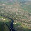
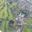
Inverness, Culcabock Road, Inverness Golf Course


Clubhouse (19th Century) - (20th Century), Golf Course (19th Century) (1885)
Site Name Inverness, Culcabock Road, Inverness Golf Course
Classification Clubhouse (19th Century) - (20th Century), Golf Course (19th Century) (1885)
Alternative Name(s) Market Stanc; Inverness Golf Course Club House
Canmore ID 98376
Site Number NH64SE 538
NGR NH 67893 44595
NGR Description Centred NH 68020 44673
Datum OSGB36 - NGR
Permalink http://canmore.org.uk/site/98376


- Council Highland
- Parish Inverness And Bona
- Former Region Highland
- Former District Inverness
- Former County Inverness-shire
NH64SE centred 68020 44673
Information transferred from NH64NE 595, which was assigned to an incorrect map sheet.
NH64NE Grid Ref: NH66 45 (unlocated)
Source: O/S 1:10,000 Map, 1992.
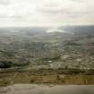
Inverness Golf Course occupies an area of about 25 hectares and is situated to the S of Culcabock Road. The golf course is partly bisected by the Mill Burn and the club house is at the N end.
It is first depicted as a golf course on the Revision Edition of the OS 25-inch map (Inverness-shire, c.1915), part of the area previously being depicted on 1st and 2nd editions of the OS 25-inch maps (1871-1880, 1908), as the 'Market Stance'.
Information from RCAHMS (DE), August 2008

