
Following the launch of trove.scot in February 2025 we are now planning the retiral of some of our webservices. Canmore will be switched off on 24th June 2025. Information about the closure can be found on the HES website: Retiral of HES web services | Historic Environment Scotland
Mousa, Broch Of Mousa


Broch (Iron Age)
Site Name Mousa, Broch Of Mousa
Classification Broch (Iron Age)
Canmore ID 944
Site Number HU42SE 1
NGR HU 45732 23660
Datum OSGB36 - NGR
Permalink http://canmore.org.uk/site/944


First 100 images shown. See the Collections panel (below) for a link to all digital images.
- Council Shetland Islands
- Parish Dunrossness
- Former Region Shetland Islands Area
- Former District Shetland
- Former County Shetland
HU42SE 1 45732 23660
(HU 4573 2366) Broch of Mousa (NR)
OS 1:10,000 1972
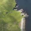
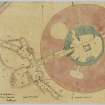
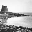
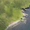
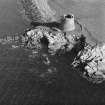
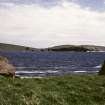
Mousa Broch is situated on the W shore of the Island of Mousa, opposite Sandwick, 15 miles S of Lerwick on the Lerwick-Sumburgh road. Access is by motor boat hired from Leebatten, Sandwick. These two monuments are open at all reasonable times on application to the Caretaker.
(Undated) information in NMRS.
Full description, photos, plans, etc. in Cruden (Cruden 1951).
S Cruden 1951
This broch is as descirbed by Cruden (Cruden 1951). Amorphous traces of outbuildings are visible, and the remains of a field wall skirt the broch.
Visited by OS (AA) 16 May 1969.
Discussion of a typicality of Mousa.
Booklet.
N Fojut 1982.
Antiquarian Observation (1862 - 1870)
Drawings by George Petrie of sites in Orkney and Shetland in sketchbook MS 28/487/7 in the Society of Antiquaries of Scotland Collection.
Field Visit (24 July 1930)
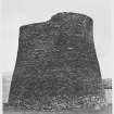
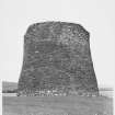
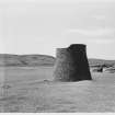
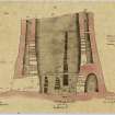
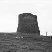
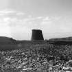
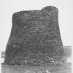
Broch of Mousa. This celebrated broch has had the good fortune to have suffered less at the hands of man and from the forces of nature than has any other example of its class. It has been preserved in an approximately complete state, and its structural features have been accepted as those typical of broch architecture. Although its general character has long been known, it is to Dryden that we owe the first authoritative description, adequately illustrated by plans and sections. In 1852 he found the interior filled up with debris to a level of 9 ft. His early observations were, therefore, confined to the upper sections of the tower, but in 1866, after the interior had been cleared by the proprietor in 1861, he was able to complete the work. His description was published in Archaeologia Scotica, v, pp. 207-11. The broch was taken over as a National Monument in 1919, when it was again cleared of debris by HM Office of Works. An account of its condition at that date, and of the steps taken by the Office of Works to prevent further deterioration appeared in the Proceedings of the Society of Antiquaries of Scotland, lvi (1921-2), pp. 172-83.
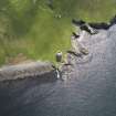
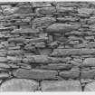
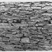
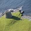
The broch stands on a low promontory on the W. shore of the Island of Mousa, overlooking the Sound, and must thus have been readily accessible by boat. A low hill sheltered it on the landward side. It was originally surrounded by a wall at some 20 ft. distance. This is now reduced to foundations which are hardly traceable except on the W. arc, but the remains show that it measured 7 ft. 6 in. in thickness. Dryden states that at one time 'beehive' huts existed within the enclosure, but these have now disappeared. Many years ago the stones were removed for building purposes on the mainland, leaving only a few fragments near the broch entrance. The debris which had long encumbered the lower part of the broch was cleared away in 1919, and the tower now rises unobscured to a height of 43 ft. 6 in. above the rock on which it is founded. The diameter is about 50 ft. at the base, but contracts at the summit to 40 ft. The profile line is not straight but follows an ogee curve, which, more nearly vertical above, swells outwards as its descends. While it is a moot point whether this feature belongs to the original design of the building, there is no doubt that the curvature has been accentuated by settlement. The greater part of the dry-built masonry has been quarried locally from the schistose slate of the neighbourhood. The walls are carefully built in regular courses, which are pinned up in the usual way. As a rule, the individual stones are exceptionally small, averaging only 1 ft. 11 in. long by 6 in. high. The lowest course on the N. side of the entrance, however, is formed of eight large slabs of sandstone, which average 3 ft. in length and vary in height from 8 in. to just under 2 ft.
HISTORICAL NOTE. In the Egils Saga, chs. 32 and 33, it is stated that about the year A.D. 900 an eloping couple from Norway were shipwrecked in Shetland on their way to Iceland, and took refuge in ‘Morseyjarborg’ or ‘Moseyjarborg’. A similar incident is recorded in the Orkneyinga Saga, ch. 101, when in 1153 a certain young Erlend carried off Margaret, Earl Harold Maddadson's mother, from Orkney to Shetland and settled down with the lady and his band of followers in ‘Morseyjarborg’, where he had laid in stores. Earl Harold followed and laid siege to the broch, but found it ‘an unhandy place to get at’ by storm. The episode ended in a reconciliation, and Erlend married Margaret.
[For a full architectural description, see RCAHMS 1946 pp. 48-55, figs. 13, 531-41]
RCAHMS 1946, visited 24 July 1930.
Field Visit (16 May 1969)
This broch is as descirbed by Cruden (Cruden 1951). Amorphous traces of outbuildings are visible, and the remains of a field wall skirt the broch.
Visited by OS (AA) 16 May 1969.
Aerial Photography (1971)
Two oblique aerial photographs of the Broch of Mousa, Shetland, taken by Mr John Dewar in 1971.
Aerial Photography (October 1973)
Oblique aerial photographs by John Dewar in October 1973.
Publication Account (2002)
HU42 6 MOUSA
HU 457237
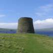
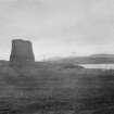
This solid based broch is exceptionally well preserved and stands on the flat rock surface of a low promontory near the west shore of Mousa Island, overlooking Mousa Sound and about a mile off the east coast of the Dunrossness peninsula (Ills. 4.62-77) (visited 5/6/63 , 29/6/87 and in July 2001).
1. DESCRIPTION
1. General
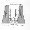
1.1 The broch tower
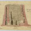
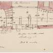
The grey stone tower of the broch of Mousa (Ills. 4.69 and 4.70) stands 43 ft 6 ins. (13.27m) high at present and may well have reached 50 ft. (15.25m) originally. At one time it was surrounded by a wall -- not necessarily contemporary with it -- 7.5 ft. (2.29 m) thick and at a distance of 20 ft. (6.1m) from its base, but this has largely disappeared [1, 182]. The wall of the tower itself is extremely well built dry stone masonry (Ill. 4.71) and immensely thick at the foundations in pro-portion to the overall diameter -- 15 ft. (4.58m) in a total of 50 ft. (15.25m) -- and is a solid mass of laid rubble for the first 13 ft. (3.96m) except for the following gaps. There is a narrow entrance passage on the west, three large, corbelled mural cells at 8, 1 and 4 o'clock, a raised door to the stairway (which also leads to a stair-foot guard cell) at 10.30 o'clock, and three large aumbries or wall cupboards at 10, 11.30 and 2.30 o'clock.
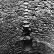
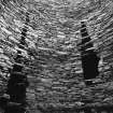
The wall on top of this massive foundation is a double one, containing in its highest part six complete mural galleries with the base of a seventh on to
The profile of the tower is markedly bell-shaped but the surveyed elevations prepared by H. M. Office of Works in 1919 suggest that this is at least partly due to the sagging of the upper storeys; the lintels of the galleries have a noticeable outward and downward tilt (Ill. 4.72). The slight outward over-hang of the top few feet is probably due to the same cause [4 , 210].
All the galleries in Mousa are wide enough to walk along (Ill. 4.75) but are a little low for comfort, varying in width from 18 ins. - 3.5 ft. (45cm - 1.07m) and in height from 4.0 - 5.5 ft. (1.22 - 1.53m). Unlike every other well preserved broch the sides of the galleries are relatively well built with few markedly projecting stones (Ill. 4.75). Each gallery starts at a gap in front of the ascending stair (which, as always, rises to the right) and ends blindly and inaccessibly behind the same stairway at the other end [4, pl. XXII].
The broch is built of the local schistose slate and most of the stones of the wall faces are small, averaging 1 ft. 11 ins. by 6 ins. (57 by 15cm). However the lowest course on the north side of the entrance has 8 large slabs measuring 3 ft. (90cm) long and 8 ins. - 2 ft. (20 - 60cm) high. Mousa is the only broch which still stands to almost its original height throughout the entire circuit of its wall, and it also stands apart from the rest in terms of its small diameter and in the relatively great thickness of the wall base (section 4 below).
Sibbald [12, 42] relates a curious story about this broch, saying that '… it is built close by the Shore, and the Sea, by an under Passage, flows up within it.' He would not have been able to see the water tank at that early date but perhaps some rainwater had accumulated inside.
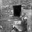
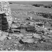
1.2 The entrance
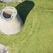
The doorway into the broch is on the west side and has been enlarged and altered in antiquity (Ills. 4.76 and 4.77). The passage is 16 ft. long and has had checks for the door at about 8 ft. from the outer end; only a single flagstone on edge survives at this point in the left wall, the other being probably concealed behind the secondary masonry on the right side (below) (Ill. 4.76). Behind the damaged door-frame is a bar-hole 4 ft. 9 ins. deep, and the opposing bar socket is also preserved. The width of the passage in front of the door frame is 3 ft. 11 ins. and the sides here are straight and parallel: beyond the door it widens to 5 ft. 1 ins. and the walls are slightly concave, narrowing again towards the inner end.
The right side of the passage beyond the door frame is now covered by a secondary facing of masonry which connects with the secondary wall running round the interior (Ill. 4.76). Likewise the inner end of the passage is filled with a raised secondary stone floor which is continuous with the surface of the secondary bench inside (below); the front of this forms a high step just behind the door-checks (Ill. 4.76).
Though the original passage lintels have been torn off, the stumps that remain show that they were thin slabs laid 5 ft. 4 ins. above the primary passage floor (Ill. 4.77). This floor is paved with stone flags, presumably laid on rock, but it is not clear if the pivot stone for the hinge post of the door, which should be set into the floor immediately behind the left check, still exists (this part of the passage is now hard to examine because of the wooden steps set there for the benefit of visitors).
In fact the present outer lintel of the passage and the first few feet of masonry above it are modern and date to 1919 [5]; the concrete reinforcement behind and above this stonework is easily seen (Ill. 4.77). As noted all the original passage lintels have been broken off at some time in the past and the reason for this destruction was evidently that a new outer opening had to be made by taking out the front lintel (which should have been more massive than the rest) and breaking away the masonry above it to a distance of about 5 ft., thus the passage was in effect prolonged upwards to about twice its original height.
When the broch was first cleared of debris in 1852 only the internal court was dug out; the floor of the entrance passage remained hidden under several feet of rubbish and it was in this state when Sir Henry Dryden re-visited the site and completed his survey [4] (Ills. 4.86 and 4.87) Because of the uncleared rubbish he did not see the bar-hole and socket in the walls behind the door-frame and he also failed to observe the stumps of the snapped-off lintels (which were visible); at that time the outer end of the passage was 5 ft. 9 ins. above the ground [4, fig. 00] (Ill. 4.86) and the passageway did not look very unusual in terms of the relatively scanty knowledge of the architecture of well preserved brochs which was available at that time. Now we would probably notice that, unlike all other known brochs with intact doorways -- the passage of Mousa is not lintelled but roofed with something akin to a shallow barrel vault. Dryden therefore could only conclude that the entrance was in approximately its original state.
However thirty years later the entrance passage had evidently been completely cleared of debris and the outer end had been exposed to its full height of about 10 ft. for the first time. A drawing (based on a photograph) published in 1883 shows the door as an unusually tall narrow slit [10, fig. 160] and another later one, taken some time before 1919 and published in 1922 [5], shows the same feature. This odd appearance of the entrance passage -- suggesting a broch built for giants -- attracted no comment until 1919 when the Office of Works, having taken over responsibility for the broch, was undertaking clearing and restoration work. During the resulting fresh examination of the old tower the snapped-off lintel stumps were noticed for the first time and it became apparent that what had hitherto been thought to be the roof of the entrance was in fact the corbelled roof of an upper chamber. The upper part of the now excessively tall doorway was therefore blocked up and a new lintel inserted at the same height as the stumps, about 5 ft. 4 ins. above the ground and the paved passage floor (Ill. 4.77). The passage was left unroofed.
Judging from the measured section, the chamber over the entrance does not seem to have extended up as far as the level of the floor of the first mural gallery (which starts at a height of 13 ft.); there appears to be at least 2 ft. of solid masonry between the two features (Ill. 4.72). It is difficult now to decide how far forward the chamber extended since its front wall was knocked out during the ancient reconstruction work; judging from the thin-ness of the stumps of the snapped-off lintels it probably extended forwards to the original and more massive front lintel which must have been needed to support the weight of the outer wall face. The chamber could then have been in effect an open-side corbelled dome, resting on the sides of the passage and on the front lintel. Now the sides of this chamber run straight forward to the modern masonry at its front end (Ill. 4.77); presumably these sides were straightened out when the passage was enlarged upwards.
The ancient upward enlargement of the entrance was presumably undertaken late in the Iron Age, because the insertion of secondary dwellings in the interior (described below) made the original doorway impassable. Alternatively, and more probably, it happened some time after the broch had been abandoned and when the accumulation of debris in the interior had produced the same effect.
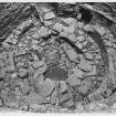
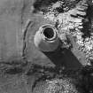
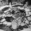
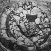
1.3 Interior floor
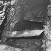
Most of the enclosed circular court except the central area is now obscured by secondary stone structures (Ills. 4.73, 4.78 and 4.79). In the centre the original, lowest floor can be seen, consisting of paving resting on the surface of the underlying rock; a rectangular tank with a flat, sloping base has been cut into this rock -- the slope presumably being the result of quarrying along the bedding plane during excavation (Ill. 4.73). On the same lowest level -- and slightly west of the centre of the court -- is a large, rectangular kerbed and paved stone hearth one end of which is obscured by the later masonry (Ill. 4.78); the hearth base is made of a single fire-fractured slab. This lowest floor is a little higher than the paving of the outer end of the entrance passage (Ill. 4.72, upper).
What must be the first alteration to the central court of the broch is a ring-shaped stone bench or low platform 1 ft. 6 ins. high at its inner edge which is faced with upright stone slabs; the bench is slightly oval in plan and is approximately con-centric with the broch wall (Ill. 4.73). The central space thus left clear (and in which the hearth and tank can be seen) measures about 6.5 x 9.5 ft.. The upper surface of the bench is flat and covered with paving slabs (Ill. 4.79) and it extends into the entrance passage for a short distance, ending at a vertical step some 1 ft. 11 ins. high and the same distance inwards from the door-checks (as noted, a short flight of wooden steps now covers the stone step). The bench surface is also level with the raised sills of the three doors to the intra-mural cells.
Either at the same time or a little later a new facing of masonry was added against the broch wall and on top of the bench; it averages 2 ft. in thickness and still stands 3 ft. high in places although it is obviously very dilapidated and has lost much of its fabric (Ills. 4.78 and 4.79). When these features were first revealed in the 19th century three wedge-shaped piers of drystone masonry (of which only one survives today) were found projecting inwards from this secondary wall; they also rested on the bench and extended inwards as far as its inner end, with which their inner ends were flush (Ill. 4.73). The surviving pier is not bonded into the secondary wall and it partly overrides the floor tank.
Thus it is clear that, despite its cramped interior, the broch of Mousa was equipped inside with a small wheelhouse some time after the tower was built. The secondary wall has gaps left in front of the doors to the mural cells and in front of the entrance passage; on the other hand it runs below the raised door to the stair without a break and also similarly in front of the three aumbries, though these are now exposed by the dilapidation of the wall. Presumably the wall and piers were at least 5 ft. high originally to allow for standing room under a pitched roof; the close link between the bench and the wall and piers on top of it suggest that all the secondary masonry was built as a unit, and that the wheelhouse needed a raised, peripheral floor area for some reason.
Some conclusions can be drawn from the sequence of masonry structures in the central court. Firstly -- the high, carefully made step in the entrance passage which leads up on to the surface of the bench indicates that the passage was still largely in its original state -- that is, it had not yet been extended upwards -- when the wheelhouse was built. Perhaps the innermost lintels had been removed to make room for people climbing the step, but the paved floor of the passage must still have been in use.
Secondly -- if, as seems likely, there was originally a complex wooden roundhouse inside the broch (resting on the scarcement ledges and presumably on a ring of posts set into the primary floor) then this must have been demolished to make way for the wheelhouse. In other words the insertion of this kind of dwelling inside Mousa did not take place in the same way as at Clickhimin (HU44 1) -- apparently after the tower had fallen into ruins -- but while it was intact. Almost certainly therefore the Mousa wheelhouse appeared as the result of some kind of evolutionary social change in this broch community rather than one brought about by newcomers in a deserted site. Thirdly -- the wheelhouse, cramped though it appears, was evidently intended to be used together with the three large mural cells, and these of course would have provided plenty of extra living space.
1.4 Mural cells and the scarcements
The three corbelled mural cells i Level 1 are tall, narrow, elongated rooms the doorways to which have their sills raised up to 2 ft. 3 ins. above their internal floors, and presumably also a similar distance above the primary floor of the central court, now obscured by the annular bench (Ill. 4.68). One obvious reason for these sills is to keep draughts from running across the floors of the cells.
Cell A, at 8 o'clock, is 14 x 5 x 11 ft. high, and B and C are similar (Ills. 4.80 and 4.81). As was described earlier the paved top of the secondary annular bench in the interior is at the level of these sills [11, pl. XLIIIa] (Ill. 4.78), and the doors themselves are relatively low, averaging some 3.5 - 4 ft. in height. Each chamber has aumbries or shelves in its inside wall face and Cell A has one with upper shelves to it, 6 ft. above the floor.
Above the lintel of each cell door are further openings, or voids, which seem designed to let light and air into the chamber behind, and also no doubt to relieve stress on the lintel, it being near the bottom of a very high wall face. The corbelled roofs are formed by the gradual inward sloping of the long sides, and by the sharper inward slope of the ends; they extend up into Level 2, to the floor of the first gallery, 13 ft. above the primary floor. The lintels of the doorways to these cells are at the same level as -- and thus form part of -- a ledge, or scarcement, running round the inner wall face at a height of 7 ft. above the original floor [6, 51: 11, pl. XLIIIa] -- or nearer 6 ft. according to the elevation; this ledge is just above the height of the stumps of the entrance lintels and forms the boundary between Levels 1 and 2 (Ills. 4.72 and 4.78).
The ledge is formed partly by the recession of the wall face above it and partly by projecting slabs; it thus projects only 3 ins. below but 6 ins. above. A second higher scarcement, built in the same way at the base of Level 3, is 12 ft. 4 ins. (13 ft?) above the primary floor, slightly below the level of the floor of the lowest mural gallery; it is just visible in Ill. 4.78 at the bottom left. There are also three recesses, or large cupboards, in the inner wall face, at 9.30, 11.30 and 2.30 o'clock; the lower parts of these openings are obscured by the later masonry.
1.5 Raised intra-mural features
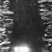
The intra-mural galleries are formed by the space between the two concentric walls of the upper part of the broch, which are bonded together (and braced apart) by horizontal rows of large, flat stone lintels (Ill. 4.75). Each row of lintels thus forms the floor of one gallery and the roof of the one below, though the floor of the bottom one (being on a solid wall base) is of paving on rubble as in the stair-foot guard cell below (Ill. 4.82). It is possible to walk along most of the galleries though most of the walls are left rougher than the facing masonry of the central court, the side of the stairway and of the mural cells. There are now five galleries preserved complete, part of the 6th is complete and roofed and the bottom part of the 7th rests on the 6th (Ill. 4.72). As noted earlier the lintelled floors tends to tilt slightly outwards and downwards, as if the outer half of the hollow wall has sagged.
The stair begins at Level 2, at the same height as the lower scarcement, and is reached by a doorway in the inner wall face with a sill about 7 ft. above the original floor level and it leads into a lobby. A large corbelled cell opens to the left of this, and has an aumbry in its wall; it can be termed a stair-foot guard cell, and most of it is built within the solid core of the basal part of the wall (Ill. 4.82). This is the first raised chamber. It is worth noting that the corbelled top of this cell projects about 2 ft. into the space of the lowest intra-mural gallery (Level 3), so that the flat slabs of its roof form what looks like a shallow flight of steps up above the gallery floor and down again (Ill. 4.75). This makes it impossible to get into the further part of the basal gallery except by crawling so one must presumably conclude that -- despite the wide, well built and relatively spacious nature of that remoter part (Ill. 4.75) --- even the lowest and widest of the mural galleries in Mousa were purely structural.
The stair rises to the right and runs up inside the wall in a continuous sweep broken by two short landings, one at a height of about 17 ft. above the floor and the other near the present summit. At the first landing (just over half way up Level 3) is a door to the interior, high above the floor of course and 4 ft. 6 ins. above the upper scarcement, and with a series of voids above it (below). There are only five steps remaining above the second landing, and no clear signs of it going much further; the sixth gallery is therefore likely to be the last, except perhaps for a parapet on top. The stair is 3 ft. wide at the bottom and the risers and treads each measure 6 ins.; the angle of ascent is thus about 45 degrees. During its whole ascent the stair has wound its way round through about half of the circumference of the tower, and this half is on the opposite side to that containing the entrance and the chambers and voids above it.
The second raised chamber is the one over the entrance passage which has already been described (Ill. 4.83). Originally it had a floor made of the flat lintels of the main entrance passage, and its roof is a shallow barrel-vault, or an open-side corbelled dome the axis of which is parallel to that of the passage below. Unlike the stair-foot cell the floor of the basal gallery (Level 3) is about 2 ft. above the roof of the chamber over the entrance, there being a band of solid masonry there of that thickness; this suggests that the barrel vault is an original Iron Age feature.
Four long vertical rows of openings, or voids, break the inner wall face and let light and air into the wall galleries [6, pl. 18: 11, pl. XLIIIb] (Ills. 4.80 and 4.83). Each of these in effect consists of a narrow slit running up the inner half of the wall and bridged at frequent intervals by stone lintels, and the usual explanation for them is that they relieve thin door lintels of the pressure of the masonry above them and generally lighten the structure; they would also have let a little light into the upper galleries, but not very much when the broch was completely roofed. One fairly short one is over the main entrance (Ill. 4.83), and long ones rise over the door to Cell B, the doorway to the stair and in the south arc of the wall (below). Also higher up over cell B is the raised door at the stair landing mentioned, with a long series of voids above it (Ill. 4.80). In the case of the voids in the south arc only two of the apertures actually penetrate to the galleries behind, the rest being mere recesses 16 ins. deep. There are other, lower voids including one over the door to Cell C. The inner wall face of the tower is more or less vertical throughout the lower, solid portion but overhangs slightly further up.
1.6 Finds
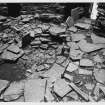
Mousa was systematically cleared of debris in 1861 and great quantities of animal bones, especially of otters, were found [4, 210]; presumably the otters inhabited the deserted ruin. Also found then were pieces of a clay pot, flat stone pot lids, a slaty stone about 12 ins long "like a three-cornered file" and a "carved model of a Norway boat in fir" about 3 ins. long.
The interior was cleared again by then Office of Works in 1919 -- after a further 4 ft. of debris had accumulated inside it, but no finds are mentioned. The few finds in the National Museum include some sherds, notably a fine black-burnished sherd of classic Iron Age type (Ill. 4.58), but the exact position is not recorded. Presumably, since the secondary structures inside the tower do not seem to have been disturbed at any time, these sherds belong to the later phase of Iron Age occupation.
1.7 Dimensions
Present greatest height 43.5 ft. (13.05m): external diameter (according to my measurements made with tape and theodolite), north - south 15.22m (50 ft. 9 ins.), east west 49.95m (49 ft. 10 ins.): internal diameter north - south 5.80m (19 ft. 4 ins.), east - west 5.10m (17 ft.): average external diameter 15.08m (50 ft. 3 ins.), internal 5.45m (18 ft. 2 ins.): the walls proportion of 64.4% is the largest in any known broch.
2. History of the site
The development of the broch of Mousa has already been discussed in Section 2 so only brief comments are made here.
2.1 Prehistory
Nothing of the site in Iron Age times is known from written records; Agricola's fleet, circumnavigating Scotland in the early AD 80s, is not thought to have landed on Shetland, although it probably sighted the islands. They are listed as 'Thule' presumably have got his information about northern Scotland from the records of Agricola's fleet, none of which are known to have survived directly.
From the foregoing structural analysis the original broch appears to have been an simple stone cylinder with a tank sunk in the floor and probably a stone hearth; doubtless there were the usual wooden furnishings inside. These would comprise a quite complex roundhouse with one,, possibly two, annular floors or balconies resting on the scarcements with doubtless a lean-to roof above these. A complete conical thatched roof must surely have capped the stone tower although how this was arranged so that it did not damage the upper parts of the drystone wall by its outward pressure is not clear (see Dun Troddan and Dun Telve -- NG81 3 and NG81 2).
At a later date the wooden roundhouse was presumably removed when the ring-shaped stone floor or bench was inserted into the interior (and into the inner end of the entrance, although presumably it is possible that the ring of posts continued to rest on the inner edge of this bench. However a later change involved the building of a small wheelhouse in the cramped interior; and this must surely have involved the removal of the primary wooden furnishings. For reasons explained earlier it seems that the original lintelled doorway was still in use almost unaltered at this time, although, if it was, the insertion of the stone bench must have made the inner end rather low. 2.2 The 18th and 19th centuries
The two recorded Norse visits to Mousa were described in Section 2; this was probably the time when the entrance passage was extended upwards.
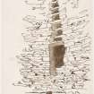
The earliest modern antiquarian account of the site was by George Low, compiled during his tour of 1774 but which remained in manuscript form for more than a century [2]. The description is fairly brief, as one might expect at that early date and when knowledge about these structures was minimal, but he does provide the first drawings of the broch (Ill. 2.0); these include what must be the earliest clear cross section of the peculiar hollow-walled construction of the tower, showing the superimposed galleries. Low climbed the stair in the wall and says he passed through seven galleries, and he repeats this error in his cutaway elevation which shows the galleries, and the stair door, in diagrammatic form from the exterior with the outer half of the wall removed. Like other early visitors Low seems to have assumed that the stair-foot guard cell was the beginning of a long gallery and he drew it as such; presumably the fact that only candles (or nothing at all) were available to light the interior explains the mistake. He offers no thoughts on the age or purpose of the structure.
Samuel Hibbert visited the broch half a century later and his 1822 description, as well as being more detailed, includes a discussion of the site [3]. As was the case in Low's time the interior was still choked with debris so that it was only possible to get into the entrance on hands and knees -- enlarged upwards though we now know it to have been at the time (Dun Dornaigil in Sutherland is in a similar situation -- NC44 2). Hibbert climbed the stairway and, like Low, counted seven galleries, again evidently mistaking the stair-foot cell for the lowest. Although he commented on the vertical rows of openings in the inner wall face (the doors to the mural cells being then concealed under debris) he did not notice the two scarcements, at least the upper one of which would have been clear. He could not therefore speculate about any wooden structures that might have been inside and concluded instead that the intra-mural galleries had been tiers of apartments for living in. He interpreted the rows of voids as openings designed to let a minimum of light and air into these galleries, necessary when women and children were sheltering in them from attack.
In general Hibbert thought that the single entrance and the high wall meant that the broch was well adapted to withstanding short sieges from piratical raiders -- which were all such raiders could presumably manage in early times in the short northern summers. In support of this idea he cited the 12th century siege of Mousa recorded in Norse sources and mentioned above; however it is not at all clear how good an illustration this is for his point since, while the besieging force could not get in, neither could those trapped inside get away, and they must have starved if not induced to surrender.
In 1852 Sir Henry Dryden began the first accurate survey of Mousa broch, and found 9 ft. of debris inside it (Ill. 4.85, top); the tower was thus in much the same state as it was at the time of Hibbert's visit, and the mural chambers were still invisible. However in 1861 the interior was cleared by Mr. John Bruce of Sum-burgh, the proprietor (he who later began the clearance at Jarlshof), who also had some repairs made to the wall; Dryden was thus able to plan further details in 1866 [4]. He saw the scarcements and he also mentioned that a number of objects had been found during Bruce's clearance (section 1.5 above).
Dryden's elevation shows the five complete intra-mural galleries, with part of the sixth, that we see now and all were correctly placed above the level of the corbelled domes of the mural cells [4, pl. xxii]. However his elevation makes it clear that he had not managed to unravel all the details of the organisation of the intra-mural features; the basal gallery is shown behind the stair-foot cell and completely isolated and therefore invisible (Ill. 4.88)! This part of the wall is in fact solid, and on his cross section Dryden only shows five complete galleries above the cells. Presumably he miscounted somehow and found he had to insert the sixth gallery below the rest. Not until the Office of Works survey in 1919 (below) was the architecture of Mousa broch properly understood.
2.4 The 20th century
In 1919 Her Majesty's Office of Works took charge of the building and again cleared out the interior in which about 4 ft. of debris -- mostly bird droppings -- had accumulated since 1861 [5]. The accumulated debris at the base of the outer wall was also removed at this time. The archaeological results of this survey have already been described.
Continued...
For Part 2 of text see Event ID 1039124.
Publication Account (2002)
HU42 6 MOUSA
HU 457237
...continued from Part 1 (Event ID 575393).
3. Discussion
The uniqueness of the broch of Mousa in terms of its small size, fine state of preservation and relative massiveness of its wall was noted by me in 1965 [8; 00 ff.]; it was suggested then that these special features meant that Mousa is the best built of all known brochs and that this may partly account for its excellent state of preservation.
Fojut has reviewed again the size, proportions and architecture of Mousa and shown that it is an exceptional building even in a Shetland context [9]. Using new data collected in the field, he notes that the wall percentage of Mousa (64.5%) is so much greater than those of its Shetland neighbours that it significantly alters the mean of that island group. On the reasonable assumption that the greater the relative massiveness of the wall base of a broch, the greater its original height, Mousa probably also stood apart from its neighbours in the Iron Age; if it was not actually the tallest, then it was certainly the tallest and most stable. Using the same kind of criteria Mousa is also found to be as atypical of Scottish brochs as a whole as of Shetland ones. Fojut also argues that the design of the intra-mural stair of Mousa may not be typical of other brochs.
Despite this uniqueness, and despite Fojut's curious question in his title "Is Mousa a Broch?" ('what else can it be?', one might ask), the tower on Mousa island can reasonably be described as the most perfectly designed hollow-walled broch of which we have detailed knowledge. It differs in detail from the rest -- and its architect seems to have been unusually inspired over some of these details -- but its basic design and architecture are in the standard broch pattern.
The conclusion drawn here from the fact that the roof of the stair-foot cell intrudes into the basal gallery has never been drawn before but it does seem to confirm in a decisive way the one that could already be drawn from the awkwardness of access to the galleries from the stair -- that the brochs' intra-mural galleries were primarily a structural feature and were not for living in or for storage.
Sources: 1. OS card HU 42 SE 1: 2. Low 1879, 181-83: 3. Hibbert 1822, 251-55: 4. Dryden 1890, 207-11: 5. Paterson 1922: 6. RCAHMS 1946, vol. 3, no. 1206, 48-55, figs. 531-41 and pls. 17 and 18: 7. Cruden 1951: 8. MacKie 1965: 9. Fojut 1981: 10. Anderson 1883: 11. Hamilton 1968. 12. Sibbald 1829, 42.
E W MacKie 2002
Publication Account (2007)
Mousa Broch, Shetland
(Institute Civil Engineers Historic Engineering Works no. HEW 2398)
This prehistoric round stone tower is located on the small uninhabited island of Mousa off the mainland about 12 miles south of Lerwick. The remains of about 500 brochs have been identified in Scotland, most of which are in Caithness, Orkney, Shetland and the Western Isles, but Mousa Broch is the only one to have survived virtually complete.
Although not strictly civil engineering, a term not known to have been used before 1754, this remarkable structure, which has stood the test of some 2000 years, certainly comes within the definition of harnessing the forces of nature for the use and convenience of man. Other good examples can be seen at Carloway, Isle of Lewis (5-51) and Clickhimin, near Lerwick, Shetland.
The broch is 43 1/2 ft high, and the overall diameter at its base is 50 ft and at the top 40 ft. The wall profile externally is not straight, but slightly curved outward at the base. The local stone is dry-built in carefully laid regular courses. Its entrance is a small rectangular opening facing the sea on the west side.
Internally the circular courtyard is 20 ft diameter at ground level. The walls average 15 ft thick at the ground and the inner face is vertical, the thickness tapers towards the top on the outside. The upper part of each wall is hollow, spanned at intervals by flagstones forming galleries. There is a stair within the wall having a width of 3 ft which ascends spirally to the wall top. It seems unlikely that the broch was roofed. The date of construction is unknown but it is possiblethat the broch existed in the first century AD. Brochs are always found near arable land and seldom far from the edge of the sea. They comprise strong towers capable of passive defence but are in no sense offensive structures. Their purpose seems to have been to provide refuge for peaceful cultivators in the face of attacks from seaborne forces.
The point of embarkation on the mainland is via the 200 ft long, 15 ft wide masonry Sandsayre Slip, with a slope of 1 in 27 and external batters of 1 1/2
in. to 1 ft, designed by D. & T. Stevenson in 1854.
R Paxton and J Shipway, 2007.
Reproduced from 'Civil Engineering heritage: Scotland - Highlands and Islands' with kind permission from Thomas Telford Publishers.

