Following the launch of trove.scot in February 2025 we are now planning the retiral of some of our webservices. Canmore will be switched off on 24th June 2025. Information about the closure can be found on the HES website: Retiral of HES web services | Historic Environment Scotland
Field Visit


Date 24 July 1930
Event ID 1125704
Category Recording
Type Field Visit
Permalink http://canmore.org.uk/event/1125704
Broch of Mousa. This celebrated broch has had the good fortune to have suffered less at the hands of man and from the forces of nature than has any other example of its class. It has been preserved in an approximately complete state, and its structural features have been accepted as those typical of broch architecture. Although its general character has long been known, it is to Dryden that we owe the first authoritative description, adequately illustrated by plans and sections. In 1852 he found the interior filled up with debris to a level of 9 ft. His early observations were, therefore, confined to the upper sections of the tower, but in 1866, after the interior had been cleared by the proprietor in 1861, he was able to complete the work. His description was published in Archaeologia Scotica, v, pp. 207-11. The broch was taken over as a National Monument in 1919, when it was again cleared of debris by HM Office of Works. An account of its condition at that date, and of the steps taken by the Office of Works to prevent further deterioration appeared in the Proceedings of the Society of Antiquaries of Scotland, lvi (1921-2), pp. 172-83.
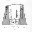
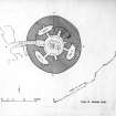
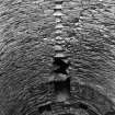
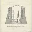
The broch stands on a low promontory on the W. shore of the Island of Mousa, overlooking the Sound, and must thus have been readily accessible by boat. A low hill sheltered it on the landward side. It was originally surrounded by a wall at some 20 ft. distance. This is now reduced to foundations which are hardly traceable except on the W. arc, but the remains show that it measured 7 ft. 6 in. in thickness. Dryden states that at one time 'beehive' huts existed within the enclosure, but these have now disappeared. Many years ago the stones were removed for building purposes on the mainland, leaving only a few fragments near the broch entrance. The debris which had long encumbered the lower part of the broch was cleared away in 1919, and the tower now rises unobscured to a height of 43 ft. 6 in. above the rock on which it is founded. The diameter is about 50 ft. at the base, but contracts at the summit to 40 ft. The profile line is not straight but follows an ogee curve, which, more nearly vertical above, swells outwards as its descends. While it is a moot point whether this feature belongs to the original design of the building, there is no doubt that the curvature has been accentuated by settlement. The greater part of the dry-built masonry has been quarried locally from the schistose slate of the neighbourhood. The walls are carefully built in regular courses, which are pinned up in the usual way. As a rule, the individual stones are exceptionally small, averaging only 1 ft. 11 in. long by 6 in. high. The lowest course on the N. side of the entrance, however, is formed of eight large slabs of sandstone, which average 3 ft. in length and vary in height from 8 in. to just under 2 ft.
HISTORICAL NOTE. In the Egils Saga, chs. 32 and 33, it is stated that about the year A.D. 900 an eloping couple from Norway were shipwrecked in Shetland on their way to Iceland, and took refuge in ‘Morseyjarborg’ or ‘Moseyjarborg’. A similar incident is recorded in the Orkneyinga Saga, ch. 101, when in 1153 a certain young Erlend carried off Margaret, Earl Harold Maddadson's mother, from Orkney to Shetland and settled down with the lady and his band of followers in ‘Morseyjarborg’, where he had laid in stores. Earl Harold followed and laid siege to the broch, but found it ‘an unhandy place to get at’ by storm. The episode ended in a reconciliation, and Erlend married Margaret.
[For a full architectural description, see RCAHMS 1946 pp. 48-55, figs. 13, 531-41]
RCAHMS 1946, visited 24 July 1930.