
Tarradale House


Country House (Period Unassigned)
Site Name Tarradale House
Classification Country House (Period Unassigned)
Canmore ID 79688
Site Number NH54NE 28
NGR NH 5527 4876
Datum OSGB36 - NGR
Permalink http://canmore.org.uk/site/79688
Ordnance Survey licence number AC0000807262. All rights reserved.
Canmore Disclaimer.
© Bluesky International Limited 2025. Public Sector Viewing Terms
- Correction
- Favourite

SC 1014802
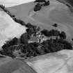
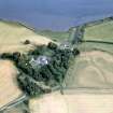
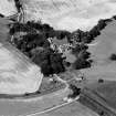
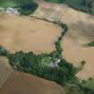
Oblique aerial view of Tarradale House with the cropmarks adjacent, looking to the ESE.
Records of Aberdeen Aerial Surveys, Aberdeen, Scotland
20/7/1984
© Copyright: Ian Ralston. Courtesy of HES.

SC 1014803
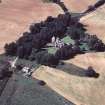
Oblique aerial view of Tarradale House with the cropmarks adjacent, looking to the NE.
Records of Aberdeen Aerial Surveys, Aberdeen, Scotland
20/7/1984
© Copyright: Ian Ralston. Courtesy of HES.

SC 1864293
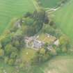
An oblique aerial view of Tarradale House, Beauly Firth, Easter Ross, looking SSE.
Papers of James Sloan Bone, landscape historian, Inverness, Highland, Scotland
1989
© Copyright: NOSAS (James S Bone Collection). Courtesy of HES.

SC 1903114
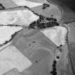
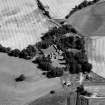
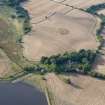
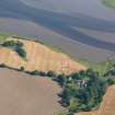
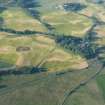
Aerial view of site of Pictish barrow cemetery, Tarradale, Muir of Ord, Easter Ross, looking SE.
Papers of James Sloan Bone, landscape historian, Inverness, Highland, Scotland
1999
© Copyright: NOSAS (James S Bone Collection). Courtesy of HES.

SC 1944615
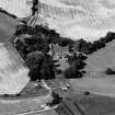
Aerial view of Tarradale House, base of the Black Isle, looking NE.
Papers of James Sloan Bone, landscape historian, Inverness, Highland, Scotland
5/8/1999
© Copyright: NOSAS (James S Bone Collection). Courtesy of HES.

DP 343075
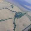
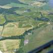
Aerial view of Tarradale barrow field and surrounding fields with cropmarks, Muir of Ord, Black Isle, looking NNE.
Papers of James Sloan Bone, landscape historian, Inverness, Highland, Scotland
19/7/2013
© Copyright: NOSAS (James S Bone Collection). Courtesy of HES.

DP 343691
Oblique aerial view of Pictish cemetery at Tarradale on the north shore of the Beauly Firth, looking SE.
Papers of James Sloan Bone, landscape historian, Inverness, Highland, Scotland
23/7/2008
© Copyright: NOSAS (James S Bone Collection). Courtesy of HES.

SC 1014928
Oblique aerial view of Tarradale House with the cropmarks adjacent, looking to the ESE.
Records of Aberdeen Aerial Surveys, Aberdeen, Scotland
20/7/1984
© Copyright: Ian Ralston. Courtesy of HES.

SC 1014931
Oblique aerial view of Tarradale House with the cropmarks adjacent, looking to the N.
Records of Aberdeen Aerial Surveys, Aberdeen, Scotland
20/7/1984
© Copyright: Ian Ralston. Courtesy of HES.

SC 1864292
An oblique aerial view of Tarradale House, Beauly Firth, Easter Ross, looking SSE.
Papers of James Sloan Bone, landscape historian, Inverness, Highland, Scotland
1989
© Copyright: NOSAS (James S Bone Collection). Courtesy of HES.

SC 1967725
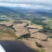
Aerial view of Tarradale and Muir of Ord, Easter Ross, looking NW.
Papers of James Sloan Bone, landscape historian, Inverness, Highland, Scotland
4/2009
© Copyright: NOSAS (James S Bone Collection). Courtesy of HES.

SC 1967735
Aerial view of Tarradale Mains under snow, Beauly Firth, looking S.
Papers of James Sloan Bone, landscape historian, Inverness, Highland, Scotland
4/2009
© Copyright: NOSAS (James S Bone Collection). Courtesy of HES.

DP 340948
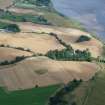
Aerial view of Tarradale House, north shore of Beauly Firth, looking NW.
Papers of James Sloan Bone, landscape historian, Inverness, Highland, Scotland
26/8/2007
© Copyright: NOSAS (James S Bone Collection). Courtesy of HES.

DP 341744
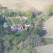
Oblique aerial view of Tarradale House, near Muir of Ord, Ross-shire, looking NE.
Papers of James Sloan Bone, landscape historian, Inverness, Highland, Scotland
19/4/2009
© Copyright: NOSAS (James S Bone Collection). Courtesy of HES.

DP 341855
Aerial view of Tarradale Estate and Tarradale House, Beauly Firth, looking NW.
Papers of James Sloan Bone, landscape historian, Inverness, Highland, Scotland
18/9/2009
© Copyright: NOSAS (James S Bone Collection). Courtesy of HES.

DP 343068
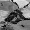
Aerial view of Tarradale House and walled garden, cropmarks, Muir of Ord, Black Isle, looking NE.
Papers of James Sloan Bone, landscape historian, Inverness, Highland, Scotland
19/7/2013
© Copyright: NOSAS (James S Bone Collection). Courtesy of HES.

DP 343071
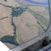
Aerial view of Tarradale Fort/ Enclosure and Barrow cemetery cropmarks, Muir of Ord, Black Isle, looking NE.
Papers of James Sloan Bone, landscape historian, Inverness, Highland, Scotland
19/7/2013
© Copyright: NOSAS (James S Bone Collection). Courtesy of HES.

DP 343118
Aerial view of Tarradale House and Mains, Black Isle, looking E.
Papers of James Sloan Bone, landscape historian, Inverness, Highland, Scotland
16/8/2013
© Copyright: NOSAS (James S Bone Collection). Courtesy of HES.

DP 343122
Aerial view of Tarradale House and Walled Garden, Black Isle, looking NE.
Papers of James Sloan Bone, landscape historian, Inverness, Highland, Scotland
16/8/2013
© Copyright: NOSAS (James S Bone Collection). Courtesy of HES.

DP 343690
Oblique aerial view of Pictish cemetery at Tarradale on the north shore of the Beauly Firth, looking SE.
Papers of James Sloan Bone, landscape historian, Inverness, Highland, Scotland
23/7/2008
© Copyright: NOSAS (James S Bone Collection). Courtesy of HES.

SC 1014800
Oblique aerial view of Tarradale House with the cropmarks adjacent, looking to the NNW.
Records of Aberdeen Aerial Surveys, Aberdeen, Scotland
20/7/1984
© Copyright: Ian Ralston. Courtesy of HES.

SC 1014930
Oblique aerial view of Tarradale House with the cropmarks adjacent, looking to the NNE.
Records of Aberdeen Aerial Surveys, Aberdeen, Scotland
20/7/1984
© Copyright: Ian Ralston. Courtesy of HES.

SC 1967724
Aerial view of Tarradale and Muir of Ord under snow, Black Isle, looking NW.
Papers of James Sloan Bone, landscape historian, Inverness, Highland, Scotland
4/2009
© Copyright: NOSAS (James S Bone Collection). Courtesy of HES.

DP 343074
Aerial view of Tarradale barrow field and surrounding fields with cropmarks, Muir of Ord, Black Isle, looking NNE.
Papers of James Sloan Bone, landscape historian, Inverness, Highland, Scotland
19/7/2013
© Copyright: NOSAS (James S Bone Collection). Courtesy of HES.

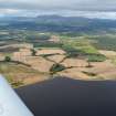
DP 343604
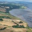
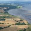
Aerial view of Tarradale and mouth of River Beauly, Black Isle, looking SSW.
Papers of James Sloan Bone, landscape historian, Inverness, Highland, Scotland
16/8/2016
© Copyright: NOSAS (James S Bone Collection). Courtesy of HES.

SC 1864294
An oblique aerial view of Tarradale House, Beauly Firth, Easter Ross, looking SSE.
Papers of James Sloan Bone, landscape historian, Inverness, Highland, Scotland
1989
© Copyright: NOSAS (James S Bone Collection). Courtesy of HES.

DP 341497
An oblique aerial view of Pictish cemetery at Tarradale, Beauly Firth, looking S.
Papers of James Sloan Bone, landscape historian, Inverness, Highland, Scotland
3/8/2008
© Copyright: NOSAS (James S Bone Collection). Courtesy of HES.

DP 341854
Aerial view of Tarradale Estate and Tarradale House, Beauly Firth, looking NW.
Papers of James Sloan Bone, landscape historian, Inverness, Highland, Scotland
18/9/2009
© Copyright: NOSAS (James S Bone Collection). Courtesy of HES.

DP 341856
Aerial view of Tarradale Estate and Tarradale House, Beauly Firth, looking NW.
Papers of James Sloan Bone, landscape historian, Inverness, Highland, Scotland
18/9/2009
© Copyright: NOSAS (James S Bone Collection). Courtesy of HES.

DP 342922
Aerial view of Tarradale on the Black Isle, looking NW.
Papers of James Sloan Bone, landscape historian, Inverness, Highland, Scotland
4/10/2012
© Copyright: NOSAS (James S Bone Collection). Courtesy of HES.

DP 342923
Aerial view of Tarradale House, and the site of the barrow cemetery, Black Isle, looking NW.
Papers of James Sloan Bone, landscape historian, Inverness, Highland, Scotland
4/10/2012
© Copyright: NOSAS (James S Bone Collection). Courtesy of HES.

DP 343119
Aerial view of Tarradale enclosure, House and Mains, Black Isle, looking E.
Papers of James Sloan Bone, landscape historian, Inverness, Highland, Scotland
16/8/2013
© Copyright: NOSAS (James S Bone Collection). Courtesy of HES.

DP 343121
Aerial view of Tarradale House and Mains, Black Isle, looking NE.
Papers of James Sloan Bone, landscape historian, Inverness, Highland, Scotland
16/8/2013
© Copyright: NOSAS (James S Bone Collection). Courtesy of HES.

DP 343605
Aerial view of Tarradale House and mouth of River Beauly, Black Isle, looking S.
Papers of James Sloan Bone, landscape historian, Inverness, Highland, Scotland
16/8/2016
© Copyright: NOSAS (James S Bone Collection). Courtesy of HES.

DP 343606
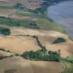
Aerial view of Tarradale House, walled garden and policies, Beauly Firth, Black Isle, looking SSE.
Papers of James Sloan Bone, landscape historian, Inverness, Highland, Scotland
16/8/2016
© Copyright: NOSAS (James S Bone Collection). Courtesy of HES.

DP 342342
Aerial view of Tarradale enclosure and Tarradale House, Beauly Firth, looking SE.
Papers of James Sloan Bone, landscape historian, Inverness, Highland, Scotland
13/12/2010
© Copyright: NOSAS (James S Bone Collection). Courtesy of HES.

DP 343056
Aerial view of Tarradale Enclosure/ Fort, Enclosure and Barrow cemetery cropmarks, Black Isle, looking NE.
Papers of James Sloan Bone, landscape historian, Inverness, Highland, Scotland
19/7/2013
© Copyright: NOSAS (James S Bone Collection). Courtesy of HES.

DP 343158
An oblique aerial view of Tarradale, near Muir of Ord, Black Isle, looking SSE.
Papers of James Sloan Bone, landscape historian, Inverness, Highland, Scotland
1/10/2013
© Copyright: NOSAS (James S Bone Collection). Courtesy of HES.

SC 1014801
Oblique aerial view of Tarradale House with the cropmarks adjacent, looking to the NW.
Records of Aberdeen Aerial Surveys, Aberdeen, Scotland
20/7/1984
© Copyright: Ian Ralston. Courtesy of HES.

SC 1944616
Aerial view of Tarradale, base of the Black Isle, looking N.
Papers of James Sloan Bone, landscape historian, Inverness, Highland, Scotland
5/8/1999
© Copyright: NOSAS (James S Bone Collection). Courtesy of HES.

SC 1944617
Aerial view of Tarradale, base of the Black Isle, looking W.
Papers of James Sloan Bone, landscape historian, Inverness, Highland, Scotland
5/8/1999
© Copyright: NOSAS (James S Bone Collection). Courtesy of HES.

DP 342191
Aerial view of Tarradale house, on N shore of Beauly Firth, looking NW.
Papers of James Sloan Bone, landscape historian, Inverness, Highland, Scotland
10/7/2010
© Copyright: NOSAS (James S Bone Collection). Courtesy of HES.

DP 343159
An oblique aerial view of Tarradale, near Muir of Ord, Black Isle, looking SE
Papers of James Sloan Bone, landscape historian, Inverness, Highland, Scotland
1/10/2013
© Copyright: NOSAS (James S Bone Collection). Courtesy of HES.

DP 343603
Aerial view of Tarradale and mouth of River Beauly, Black Isle, looking SSW.
Papers of James Sloan Bone, landscape historian, Inverness, Highland, Scotland
16/8/2016
© Copyright: NOSAS (James S Bone Collection). Courtesy of HES.

SC 1903138
Aerial view of site of Pictish barrow cemetery, Tarradale, Muir of Ord, Easter Ross, looking S.
Papers of James Sloan Bone, landscape historian, Inverness, Highland, Scotland
1999
© Copyright: NOSAS (James S Bone Collection). Courtesy of HES.

DP 341388
An almost aerial view of Tarradale House, near Muir of Ord, looking N.
Papers of James Sloan Bone, landscape historian, Inverness, Highland, Scotland
19/5/2008
© Copyright: NOSAS (James S Bone Collection). Courtesy of HES.

DP 342920
Aerial view of Tarradale House, Muir of Ord, looking N.
Papers of James Sloan Bone, landscape historian, Inverness, Highland, Scotland
4/10/2012
© Copyright: NOSAS (James S Bone Collection). Courtesy of HES.

DP 342921
Aerial view of Tarradale on the Black Isle, looking NW.
Papers of James Sloan Bone, landscape historian, Inverness, Highland, Scotland
4/10/2012
© Copyright: NOSAS (James S Bone Collection). Courtesy of HES.

DP 343073
Aerial view of Tarradale House and cropmarked fields general views, Muir of Ord, Black Isle, looking NE.
Papers of James Sloan Bone, landscape historian, Inverness, Highland, Scotland
19/7/2013
© Copyright: NOSAS (James S Bone Collection). Courtesy of HES.

DP 343654
Oblique aerial view of the Bellevue and Tarradale Mains area, N shore of Beauly Firth, looking NE.
Papers of James Sloan Bone, landscape historian, Inverness, Highland, Scotland
18/7/2018
© Copyright: NOSAS (James S Bone Collection). Courtesy of HES.

SC 1967277
Aerial view of Tarradale House, Tarradale, Black Isle, looking NNW.
Papers of James Sloan Bone, landscape historian, Inverness, Highland, Scotland
1987
© Copyright: NOSAS (James S Bone Collection). Courtesy of HES.

DP 342343
Aerial view of Tarradale House and pier and embankment at Bellevue, Beauly Firth, looking WNW.
Papers of James Sloan Bone, landscape historian, Inverness, Highland, Scotland
13/12/2010
© Copyright: NOSAS (James S Bone Collection). Courtesy of HES.

DP 343117
Aerial view of Tarradale House and Mains, Black Isle, looking E.
Papers of James Sloan Bone, landscape historian, Inverness, Highland, Scotland
16/8/2013
© Copyright: NOSAS (James S Bone Collection). Courtesy of HES.

DP 343120
Aerial view of Tarradale enclosure, House and Mains, Black Isle, looking E.
Papers of James Sloan Bone, landscape historian, Inverness, Highland, Scotland
16/8/2013
© Copyright: NOSAS (James S Bone Collection). Courtesy of HES.


- Council Highland
- Parish Avoch
- Former Region Highland
- Former District Ross And Cromarty
- Former County Ross And Cromarty
NH54NE 28 5527 4876
Country House - outside study area.
2nd Mill AD
CFA/MORA Coastal Assessment Survey 1998

