|
Manuscripts |
MS 307/230 |
Historic Scotland. Scottish Burgh Survey. |
Scottish Burgh Survey-Cartographic Evidence
3 copies of map of Fortrose and Rosemarkie;
OS 25" Ross-shire, Rosemarkie Parish, sh. XC.3, 1872;
OS 25" Ross-shire, Avoch and Rosemarkie Parish, sh. XC.6, 1872;
OS 25" Ross-shire, Rosemarkie Parish, sh XC.7, 1872 |
|
Item Level |
|
|
Manuscripts |
MS 307/244 |
Historic Scotland. Scottish Burgh Survey. |
Scottish Burgh Survey-Record Cards |
|
Item Level |
|
|
Print Room |
RC 1147 PO |
Copies of records from the National Records of Scotland, Edinburgh, Scotland |
Historic photograph.
General view. |
c. 1900 |
Item Level |
|
|
Print Room |
RC 1198 PO |
|
Historic photograph.
General view. |
c. 1900 |
Item Level |
|
|
Photographs and Off-line Digital Images |
RC 1198 |
|
Copy of historic photograph showing general view. |
c. 1900 |
Item Level |
|
|
Photographs and Off-line Digital Images |
RC 1147 |
Copies of records from the National Records of Scotland, Edinburgh, Scotland |
Copy of historic photograph showing general view. |
c. 1900 |
Item Level |
|
 |
On-line Digital Images |
DP 068030 |
RCAHMS Aerial Photography Digital |
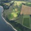
Oblique aerial view centred on a symbol cut in the grass, probably by artist Brian Wright with Kincurdie House with the town of Rosemarkie to the SE, taken from the NE. |
5/8/2009 |
Item Level |
|
 |
On-line Digital Images |
DP 273365 |
Historic Environment Scotland |
Oblique aerial view. |
24/3/2018 |
Item Level |
|
 |
On-line Digital Images |
DP 340834 |
Papers of James Sloan Bone, landscape historian, Inverness, Highland, Scotland |
Aerial view of Rosemarkie, Black Isle, looking NE. |
29/4/2007 |
Item Level |
|
 |
On-line Digital Images |
DP 341328 |
Papers of James Sloan Bone, landscape historian, Inverness, Highland, Scotland |
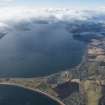
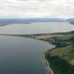
General oblique aerial view of the Inner Moray Firth with Chanonry Ness in the foreground, looking SW. |
18/5/2008 |
Item Level |
|
 |
On-line Digital Images |
DP 341543 |
Papers of James Sloan Bone, landscape historian, Inverness, Highland, Scotland |
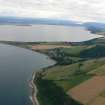
Oblique aerial view of Chanonry Point on the Moray Firth, looking SW. |
8/8/2008 |
Item Level |
|
 |
On-line Digital Images |
DP 341544 |
Papers of James Sloan Bone, landscape historian, Inverness, Highland, Scotland |
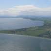
Oblique aerial view of Chanonry point on the Moray Firth with Fortrose and Rosemarkie, looking SW. |
8/8/2008 |
Item Level |
|
 |
On-line Digital Images |
DP 341882 |
Papers of James Sloan Bone, landscape historian, Inverness, Highland, Scotland |
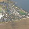
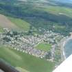
An oblique aerial view of Rosemarkie, Black Isle, looking N. |
17/1/2010 |
Item Level |
|
 |
On-line Digital Images |
DP 342505 |
Papers of James Sloan Bone, landscape historian, Inverness, Highland, Scotland |
Aerial view of Rosemarkie, Black Isle, looking N. |
3/7/2011 |
Item Level |
|
 |
On-line Digital Images |
DP 342506 |
Papers of James Sloan Bone, landscape historian, Inverness, Highland, Scotland |
Aerial view of Rosemarkie, Black Isle, looking NE. |
3/7/2011 |
Item Level |
|
 |
On-line Digital Images |
DP 342539 |
Papers of James Sloan Bone, landscape historian, Inverness, Highland, Scotland |
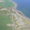
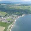
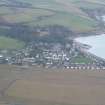
Aerial view of Rosemarkie and Rosemarkie beach, Black Isle, looking N. |
14/1/2012 |
Item Level |
|


