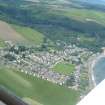
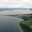
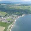
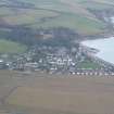
Accessibility

Font Size

100% 150% 200%

Background Colour

Default Contrast
Close Reset

Pricing Change

New pricing for orders of material from this site will come into place shortly. Charges for supply of digital images, digitisation on demand, prints and licensing will be altered. 


Upcoming Maintenance

Please be advised that this website will undergo scheduled maintenance on the following dates:

Thursday, 9 January: 11:00 AM - 3:00 PM

Thursday, 23 January: 11:00 AM - 3:00 PM

Thursday, 30 January: 11:00 AM - 3:00 PM

During these times, some functionality such as image purchasing may be temporarily unavailable. We apologise for any inconvenience this may cause.


Rosemarkie, General

Burgh (Medieval), Town (Medieval) - (Post Medieval)

Site Name Rosemarkie, General

Classification Burgh (Medieval), Town (Medieval) - (Post Medieval)

Canmore ID 77212

Site Number NH75NW 74

NGR NH 73 57

Datum OSGB36 - NGR

Permalink http://canmore.org.uk/site/77212
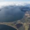
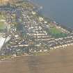
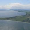
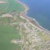
Ordnance Survey licence number AC0000807262. All rights reserved.
Canmore Disclaimer. © Bluesky International Limited 2025. Public Sector Viewing Terms

Toggle Aerial | View on large map

Digital Images

Administrative Areas

  • Council Highland
  • Parish Rosemarkie
  • Former Region Highland
  • Former District Ross And Cromarty
  • Former County Ross And Cromarty

Activities

Field Visit (June 1979)

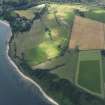
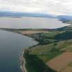
Rosemarkie NH 737 576 NH75NW 10

Rosemarkie probably attained the status of a royal burgh in the 13th century, but the earliest documentary evidence dates from 1455, when the burgh of Fortrose was annexed. Nothing can now be seen of what may have been a motte at Courthill (NH 735 576).

RCAHMS 1979, visited June 1979

NSA, xiv (Ross and Cromarty), 353-4; Armitage 1912, 322; Pryde 1965, 28-30, no. 64; 41, no. 98

References

MyCanmore Image Contributions


Contribute an Image

MyCanmore Text Contributions