
Toward Point, Toward Point Lighthouse


Lighthouse (19th Century)
Site Name Toward Point, Toward Point Lighthouse
Classification Lighthouse (19th Century)
Alternative Name(s) Toward Lighthouse And Principal's House, Cowal
Canmore ID 68122
Site Number NS16NW 12
NGR NS 13623 67226
Datum OSGB36 - NGR
Permalink http://canmore.org.uk/site/68122


- Council Argyll And Bute
- Parish Dunoon And Kilmun
- Former Region Strathclyde
- Former District Argyll And Bute
- Former County Argyll
NS16NW 12.00 13623 67226
Lighthouse [NAT]
OS 1:10,000 map, 1981.
NS16NW 12.01 NS 1357 6723 Assistant's House
NS16NW 12.02 NS 1359 6724 New House
NS16NW 12.03 NS 1365 6720 Foghorn
Not to be confused with Toward Point Perch Beacon (NS 13529 67041), for which see NS16NW 77.
NMRS REFERENCE:
Toward Point Lighthouse.
Lighthouse dates from 1812.
House dates from 1867.
(Undated) information in NMRS.
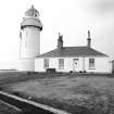
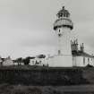
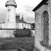
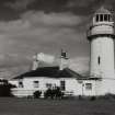
(Location cited as NS 136 672). Toward Lighthouse, built 1812 by the Cumray [Cumbrae] Lighthouse Trust. A tapering stone tower, with corbelled walkway, standard-pattern lantern, and pointed windows. The keepers' houses are single-storey.
J R Hume 1977.
Field Visit (September 1988)
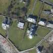
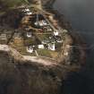
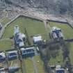
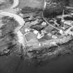
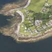
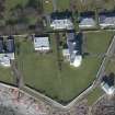
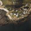
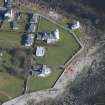
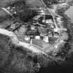
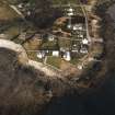
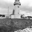
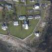
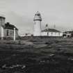
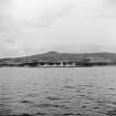
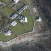
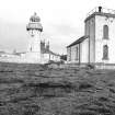
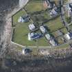
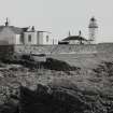
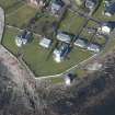
This lighthouse, built in 1812 by the Cumbrae Lighthouse Trust (1), is situated on Toward Point, the low promontory at the SE angle of the Cowal peninsula, and at the S entrance to the inner Firth of Clyde and the Kyles of Bute. The tower and adjacent principal keeper's house stand in the E part of a polygonal stone-walled enclosure, with an assistant keeper's house of late 19th-century date set parallel to them inside the W wall, and a small dwelling of the 1920s between the two ranges, towards the N. Outside the enclosure to the E there was a hen-house, of which traces survive on the rocky foreshore, and on the shore to the SE there stands a disused brick-built foghorn-house of late 19th-century date, single storeyed but with a two-storeyed SE tower which carried the foghorn itself (2).
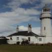
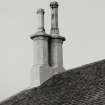
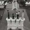
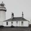
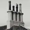
The tower originally rose within the S perimeter of a single-storeyed circular keepers' house ll.3m in overall diameter, which contained two rooms of curvilinear plan on each side of the entrance-passage to the N door of the tower (3). Raggle-lines on the W and E faces of the tower mark the circular house had been replaced by a more conventional single-storeyed rectangle, 15.6m from N to S by 9.3m, linked to the NE face of the tower by a lm length of wall. This house is faced with droved ashlar and has a hipped slated roof above a projecting blocking-course, with tall octagonal chimneystacks. The E front is of four bays, with a door in the second N bay, and another door in the S wall opposite the tower doorway is now enclosed in a modern porch in the W re-entrant.
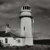
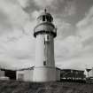
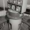
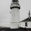
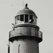
The tower itself, which is faced with limewashed droved ashlar, is 5.5m in diameter at base and now rises to a height of 19m above high-water mark, having been raised by about 2.5m by the enlargement of the glazed lantern and its supporting wall some time after 1867 (4). Above a base-course and a projecting band which corresponded to the eaves-level of the original encircling keepers' house, the tower rises with a steady batter, slightly intaken above the first of three stages each lit by lancet-windows, some of which are dummies. A projecting course below the lantern carries the inner edge of a latticed walkway with a plain cast-iron balcony, supported by shaped iron brackets, but early drawings show that the masonry wall of the original lantern had a diameter of only 3m rather than the present 4.2m, with the walkway carried on the wall-head and a balcony of similar design rising from the projecting course. Thirteen brass ventilator-tubes protrude through the upper part of the wall below the glazed lantern, which like its predecessor has vertical cast-iron glazing-bars and a metal-covered dome.
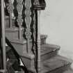
The outer face of the entrance-doorway of the tower was cut back after the removal of the original encircling house. The ground storey contains a peripheral chamber, probably a fuel-store, and a stone spiral stair surrounds a hollow newel which contained the weights for the clockwork mechanism driving the original revolving light. The stairs are interrupted by a small half-landing and continue to a floor below the lantern, pierced by a small balustraded circular opening which allowed the former weights to enter the hollow newel. From this level a flight of stone stairs with an ornate cast-iron balustrade of mid 19th-century date leads up to the remodelled lantern-room, which contains a modern electric light with a range of 35km.
This lighthouse, first proposed in the early 1790s, was completed in 1812 on land provided by James Lamont of Knockdow, who also supplied local stone and lime which was produced in a kiln about 250m W of the lighthouse. For shipping which had cleared the Cumbrae light to the S, Toward provided a bearing for about 15km until the Cloch light came into view opposite Dunoon, at the approach to Greenock. The light, which was automated in the 1960s, is now maintained by the Clyde Port Authority, based in Greenock, and the dwellings have been sold to private owners (5*).
RCAHMS 1992, visited September 1988
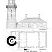
Measured Survey (7 September 1988)
RCAHMS surveyed Toward Point Lighthouse on 7 September 1988 producing an east elevation and ground plan at a scale of 1:100. The elevation and plan were redrawn in ink and published at a scale of 1:250 (RCAHMS 1992, 523B).

