Accessibility

Font Size

100% 150% 200%

Background Colour

Default Contrast
Close Reset

Kirk Hill

Fort (Prehistoric), Palisaded Enclosure (Prehistoric)

Site Name Kirk Hill

Classification Fort (Prehistoric), Palisaded Enclosure (Prehistoric)

Canmore ID 67858

Site Number NY48NE 1

NGR NY 46278 86393

Datum OSGB36 - NGR

Permalink http://canmore.org.uk/site/67858

Ordnance Survey licence number AC0000807262. All rights reserved.
Canmore Disclaimer. © Bluesky International Limited 2025. Public Sector Viewing Terms

Toggle Aerial | View on large map

Digital Images

Oblique aerial view.
Oblique aerial view.General oblique aerial view looking over the sheep stell towards the remains of the fort, palisaded enclosure, farmstead, cottage and sheepfold, taken from the SW.Map of archaeological landscape around Kirkhill, Liddesdale Kirk Hill, NY48NE 1, Ordnance Survey index card, page number 2, VersoOblique aerial view.Oblique aerial view of Kirk Hill centred on the remains of a fort and palisaded enclosure with a farmstead, field-system, rig and boundary banks and buildings, enclosures, lazy-beds and quarries adjacent, taken from the E.General oblique aerial view looking over the sheep stell towards the remains of the fort, palisaded enclosure, farmstead, cottage and sheepfold, taken from the WSW.Kirk Hill, NY48NE 1, Ordnance Survey index card, RectoOblique aerial view.Oblique aerial view of Kirk Hill centred on the remains of a fort and palisaded enclosure with a farmstead, field-system, rig and boundary banks and buildings, enclosures, lazy-beds and quarries adjacent, taken from the E.Oblique aerial view of Kirk Hill centred on the remains of a fort and palisaded enclosure with a farmstead, field-system, rig and boundary banks and buildings, enclosures, lazy-beds and quarries adjacent, taken from the N.Oblique aerial view of Kirk Hill centred on the remains of a fort and palisaded enclosure with a farmstead, field-system, rig and boundary banks and buildings, enclosures, lazy-beds and quarries adjacent, taken from the SW.Oblique aerial view of Kirk Hill centred on the remains of a fort and palisaded enclosure with the remains of a farmstead, field-system, rig and boundary banks adjacent, taken from the W.Oblique aerial view centred on the remains of the fort and palisaded enclosure, field-system, rig and boundary banks with enclosures, lazy beds, boundary ditches, field-system and rig adjacent, taken from the WNW.Oblique general aerial view of Ettleton Sike centred on the burial-ground, taken from the E.Oblique aerial view.Oblique aerial view of Kirk Hill centred on the remains of a fort and palisaded enclosure with buildings, enclosures, lazy-beds, quarries and a farmstead, field-system, rig and boundary banks adjacent, taken from the SW.Oblique aerial view of Side centred on the remains of boundary ditches, farmstead, sheep stell, field-system, rig and lazy beds with a farmstead, field-system, rig and boundary banks adjacent and a fort and palisaded enclosure in the background, taken from the S.Oblique aerial view of Kirk Hill centred on the remains of a fort and palisaded enclosure with a farmstead, field-system, rig and boundary banks and buildings, enclosures, lazy-beds and quarries adjacent, taken from the W.Oblique aerial view centred on the remains of the fort and palisaded enclosure with field-system, rig, boundary banks, enclosures and lazy beds adjacent, taken from the NE.Oblique aerial view centred on the remains of the fort and palisaded enclosure with field-system, rig, boundary banks, enclosures and lazy beds adjacent, taken from the NW.General oblique aerial view of Ettleton Sike centred on the burial-ground, taken from the E.Oblique aerial view of Kirk Hill centred on the remains of a fort and palisaded enclosure with buildings, enclosures, lazy-beds, quarries and a farmstead, field-system, rig and boundary bank adjacent, taken from the WNW.Oblique aerial view of Kirk Hill centred on the remains of a fort and palisaded enclosure with a farmstead, field-system, rig and boundary banks and buildings, enclosures, lazy-beds and quarries adjacent, taken from the NW.Oblique aerial view of Kirk Hill centred on the remains of a fort and palisaded enclosure with the remains of buildings, enclosures, lazy-beds, quarries, a farmstead, field-system, rig and boundary banks adjacent, taken from the E.Oblique aerial view centred on the remains of the fort and palisaded enclosure, field-system, rig and boundary banks with enclosures, lazy beds, boundary ditches, field-system and rig adjacent, taken from the SW.Publication drawing; Earthwork, Kirk Hill.Oblique aerial view of Kirk Hill centred on the remains of a fort and palisaded enclosure with buildings, enclosures, lazy-beds, quarries and a farmstead, field-system, rig and boundary banks adjacent, taken from the W.General oblique aerial view looking over the sheep stell towards the remains of the fort, palisaded enclosure, farmstead, cottage and sheepfold, taken from the SW.Map showing the archaeological landscape around Kirkhill, LiddesdaleKirk Hill, NY48NE 1, Ordnance Survey index card, RectoOblique aerial view of Kirk Hill centred on the remains of a fort and palisaded enclosure with buildings, enclosures, lazy-beds, quarries and a farmstead, field-system, rig and boundary bank adjacent, taken from the WNW.Oblique aerial view.Oblique aerial view of Kirk Hill centred on the remains of a fort and palisaded enclosure with the remains of buildings, enclosures, lazy-beds, quarries, a farmstead, field-system, rig and boundary banks adjacent, taken from the E. Digital image of D/24598/CN.Oblique aerial view.Oblique aerial view centred on the remains of the fort and palisaded enclosure with field-system, rig, boundary banks, enclosures and lazy beds adjacent, taken from the SW.Kirk Hill, NY48NE 1, Ordnance Survey index card, page number 1, RectoPlane-table survey; Earthwork, Kirk Hill.Oblique aerial view.Oblique aerial view.Oblique aerial view.Digital map (colour) of archaeological landscape around Kirkhill, LiddesdaleOblique aerial view of Kirk Hill centred on the remains of a fort and palisaded enclosure with buildings, enclosures, lazy-beds, quarries and a farmstead, field-system, rig and boundary bank adjacent, taken from the NW.

Administrative Areas

  • Council Scottish Borders, The
  • Parish Castleton
  • Former Region Borders
  • Former District Roxburgh
  • Former County Roxburghshire

Activities

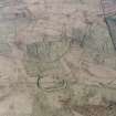
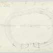
Measured Survey (7 June 1933)

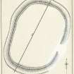
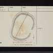
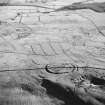
The fort at Kirk Hill was surveyed by plane-table on 7 June 1933, and the drawing was amended in 1948. The plan was redrawn in ink, with amendments made after the 1948 visit, and published at a reduced scale in 1956 (RCAHMS 1956 fig. 135). The plan does not show the palisade trenches noted by RCAHMS (DCC) in 1996.

Field Visit (3 October 1948)

Earthwork, Kirk Hill NY 463 864

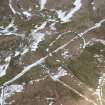
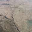
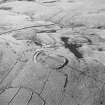
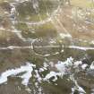
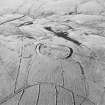
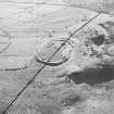
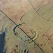
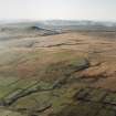
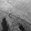
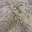
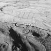
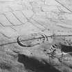
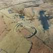
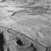
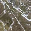
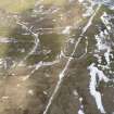
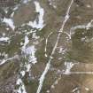
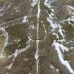
On a slight ridge which forms the summit of Kirk Hill, a little over a mile SW. of Newcastleton and at a height of 922 ft. O.D., there is a sub-oval enclosure surrounded by a massive rampart and measuring internally 295 ft. from NNE. to SSW. by 215 ft. along the transverse axis (plan, Fig. 135). The rampart material, consisting of earth and small pieces of broken rock, has been obtained partly from a deep outer ditch, probably rock-cut, and partly from a broad and rather hollow internal scoop. Although no stonework is now visible, it is possible that this material was originally revetted with dry walling since it is reported that a great quantity of stones was taken from the site to build the adjacent field-dykes (PSAS vi, 106), one of which crosses the earthwork approximately on the line of the major axis. Today the rampart stands to a maximum height of 2 ft. internally and 12 ft. externally. The only entrance, in the centre of the ESE. side, is now 37 ft. wide; but it occurs at a point where the top end of a later field-system impinges on the earthwork and may therefore have been widened by ploughing. The interior, which is covered with thick, tussocky grass, contains no sign of structures. The impression given by the earthwork is that it is later than the prehistoric period.

RCAHMS 1956, visited 3 October 1948

OS Map: N xl (‘Fort’).

Field Visit (23 July 1979)

NY48NE 1 4625 8638.

(NY 4625 8638) Ancient Earthwork (NAT)

OS 6" map (1957)

A probable settlement, well preserved, and generally as described by RCAHMS.

Surveyed at 1:10,000.

Visited by OS (MJF) 23 July 1979

Field Visit (18 April 1996)

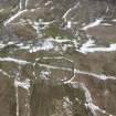
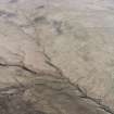
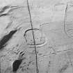
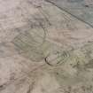
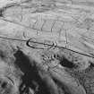
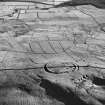
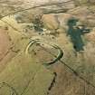
The summit of Kirk Hill is crowned by a univallate fort. Oval on plan, the interior measures 90m from NNE to SSW by about 62m transversely within a rampart 4.5m in thickness and up to 2m in height. The rampart is supplemented by an external ditch about 4.6m broad and up to 1.5m deep. There is an 11m wide entrance on the ESE, where the defences have been slighted by ploughing and are overlain by the upper edge of a post-medieval field-system (NY48NE145). A drystone march dyke bisects the fort along its long axis and an OS triangulation station has been sited on the rampart on the S. A causeway across the ditch on the NNE is probably related to the construction of the march dyke.

The N half of the interior of the fort is flat, rising gently in the S half, which has been cultivated. The lines of two roughly concentric palisade trenches set about 5.5m apart can be traced around the W, N and NE of the interior, the outer immediately within the rampart. This palisaded enclosure is either circular or oval and measures at least 48m in diameter.

(LID96 365)

Visited by RCAHMS (DCC) 18 April 1996

Aerial Photography (1 December 1997)

Aerial Photography (27 March 2000)

Note (3 July 2014 - 23 May 2016)

This fort is situated on the rounded summit of Kirk Hill and is bisected by a stone march dyke that traverses the hill from NNE to SSW. Oval on plan, the fort measures 90m from NNE to SSW by 62m transversely (0.49ha) within a rampart 4.5m in thickness by 0.6m in height internally, and 2m externally, and an external ditch 4.6m in breadth by 1.5m in depth. The entrance on the ESE is now 11m wide as a result of post medieval cultivation ploughing, which has also extended across the S half of the interior. In the northern half, however, on the W, N and NE, there are traces of two concentric palisade trenches set about 5.5m apart within the line of the rampart and describing an enclosure measuring at least 48m across.

Information from An Atlas of Hillforts of Great Britain and Ireland – 23 May 2016. Atlas of Hillforts SC1129

Sbc Note

Visibility: This is an upstanding earthwork or monument.

Information from Scottish Borders Council

References

MyCanmore Image Contributions


Contribute an Image

MyCanmore Text Contributions