Pricing Change
New pricing for orders of material from this site will come into place shortly. Charges for supply of digital images, digitisation on demand, prints and licensing will be altered.
Upcoming Maintenance
Please be advised that this website will undergo scheduled maintenance on the following dates:
Thursday, 9 January: 11:00 AM - 3:00 PM
Thursday, 23 January: 11:00 AM - 3:00 PM
Thursday, 30 January: 11:00 AM - 3:00 PM
During these times, some functionality such as image purchasing may be temporarily unavailable. We apologise for any inconvenience this may cause.
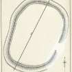
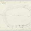
Measured Survey


Date 7 June 1933
Event ID 1130143
Category Recording
Type Measured Survey
Permalink http://canmore.org.uk/event/1130143
The fort at Kirk Hill was surveyed by plane-table on 7 June 1933, and the drawing was amended in 1948. The plan was redrawn in ink, with amendments made after the 1948 visit, and published at a reduced scale in 1956 (RCAHMS 1956 fig. 135). The plan does not show the palisade trenches noted by RCAHMS (DCC) in 1996.