
Pricing Change
New pricing for orders of material from this site will come into place shortly. Charges for supply of digital images, digitisation on demand, prints and licensing will be altered.
Learable


Head Dyke (Medieval) - (Post Medieval), Kiln Barn(S) (Medieval) - (Post Medieval), Township (Medieval) - (Post Medieval)
Site Name Learable
Classification Head Dyke (Medieval) - (Post Medieval), Kiln Barn(S) (Medieval) - (Post Medieval), Township (Medieval) - (Post Medieval)
Alternative Name(s) Learable Hill
Canmore ID 6710
Site Number NC82SE 20
NGR NC 895 236
Datum OSGB36 - NGR
Permalink http://canmore.org.uk/site/6710


- Council Highland
- Parish Kildonan
- Former Region Highland
- Former District Sutherland
- Former County Sutherland
Field Visit (21 January 1977)
NC82SE 20.00 895 236.
(NC 895236) Learable (NAT)
OS 6" map, (1963)
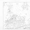
This depopulated township consists of twenty-four buildings with associated enclosures and two corn-drying kilns. At NC 89632334 there is a mounded feature 11.0m x 9.0m x 0.5m high; on its surface are five shallow depressions about 2.0m in diameter. Four further depressions lie about 10.0m to the E. Another group is to be seen at the N end of the township; all are of uncertain purposes. There are clear remains of narrow rig and associated lynchets within an area of about ten hectares of cultivated ground, bounded on the W side by the township wall.
Visited by OS (JB) 21 January 1977
Field Visit (5 June 1991)
NC82SE 20.01 895 236.
This township is divided into two main clusters, each with a kiln-barn, at NC 896 233 and NC 894 237, separated by a distance of some 200m, but there are also a number of outlying buildings, both within and without the ring-dyke, including a group of four buildings at NC 897 234 on the N side of the shepherd's cottage.
Some thirty buildings have been identified, ranging in length from 5.4m to 33.7m and in breadth from 2m to 3.7m within drystone-rubble walls between 0.6m and 1m in thickness, of which nine were in excess of 15m in length and are referred to henceforth as long-buildings. There are five of the long-buildings in the more northerly of the two main clusters and four in the southern cluster. In general, the buildings were constructed across the slope, with squared angles, but the sidewalls were often slightly bowed, particularly in the long-buildings. Where it was possible to tell, entrances were in one of the sides; some of the long-buildings appeared to have gaps in the lower ends, but this may be attributed to the presence of an exit for a byre-drain. Six of the long-buildings were sub-divided into two unequal compartments, and one had three (KILD91 325). None of the buildings stood sufficiently high to determine the nature of the roof, the best preserved standing up to 0.85m in height and the majority less than 0.6m. Three of the group of four buildings on the N side of the shepherd's cottage have been disturbed in the construction and cultivation of the embanked field with which the cottage is associated.
There are two kiln-barns, one at each of the two main clusters. Both are built with the kiln set into the slope at the upper end of the barn, with the flue opening into it. They are of similar size, 7.7m and 6.5m in length by 2.9m and 3m in breadth respectively within rubble-faced walls 0.8m and 1.15m in thickness, and their bowls measure 1.8m and 1.65m in diameter respectively by 0.9m in depth.
There are a number of signs of sequence in the township, not least that the ring-dyke is later than some of the buildings (KILD91 327, 298 and 299). Three buildings are overlain by a drystone enclosure in the southern cluster (KILD91 301-3) and a second enclosure overlies the end of a long-building (KILD91 312). One building (KILD91 305) at the S end of the township, which was better preserved than the others, still stood to 1.4m in height, and atypically had two outshots. Its preservation and atypicallity suggest it may post-date the rest of the buildings.
(KILD91 296, 298-306, 308-318, 323-335, 420-422)
Visited by RCAHMS (PJD) 5 June 1991.
Field Visit (5 June 1991)
The township of Learable and its associated fields are largely encompassed by a ring-dyke, which runs in a great curve to the W of the River Helmsdale on the E flank of Learable Hill, enclosing an area of some 40 hectares. Within, or immediately adjacent to, the area of the township there are a variety of archaeological monuments in addition to the buildings and cultivation remains; these include three hut-circles, several enclosures, three burnt mounds, two buildings of Pitcarmick-type, a variety of clearance heaps and a field-system.
The lands of 'Leryboll' are first documented in a charter of confirmation of Queen Mary in favour of Helen Stewart, widow of the Earl of Errol in 1548 (Reg Magni Sig Scot 1546-1580). The farm of Learable is listed in a rental of 1687 (NLS Dep 313/2100) and there are six tenants, each with one hearth, listed in the Hearth Tax return of 1690 (SRO E69/23/1). It is mapped by General Roy in the mid 18th century (Roy 1747-55, sheet 36/2) and was let at wadset in 1744 (NLS Sutherland MSS, Dep 313/307) and in 1802 to one Robert Pope, before being finally redeemed in 1815 at the time of the clearance of these lands (Adam 1972).
20.01 NC 895 236 Township, including two kiln-barns
(KILD91 296, 298-306, 308-318, 323-335, 420-422) 20.02 NC 895 236 Boundary Dyke; Cultivation Remains
20.03 NC 8949 2371 Hut-circle; enclosures (KILD91 320-22)
20.04 NC 8960 2397 Hut-circle (KILD91 206)
20.05 NC 8980 2380 Hut-circle (KILD91 209)
20.06 NC 8973 2365 Burnt Mound (KILD91 205)
20.07 NC 8949 2337 Burnt Mound (KILD91 297)
20.08 NC 8961 2329 Burnt Mound (KILD91 307)
20.09 NC 8938 2362 Buildings: Round-ended (KILD91 418-19)
20.10 NC 896 239 Field-system; Hut (possible) (KILD91 207)
20.11 NC 8959 2381 Enclosure (KILD91 423)
20.12 NC 8950 2360 Enclosure (KILD91 319)
20.13 NC 8940 2353 Enclosure (KILD91 295)
Reg Mag Sig Reg Scot, VI, 1546-1580, no.241
R J Adam 1972, vol 1, App A & lvii ff.
(KILD91 205-209, 295-335, 418-423)
Visited by RCAHMS (PJD) 5 June 1991.
Note (20 February 2002)
Fourteen unroofed buildings, one roofed building, five enclosures, a subdivided field and a head-dyke are depicted on the 1st edition of the OS 6-inch map (Sutherland 1879, sheet lxxix). Twenty-eight unroofed buildings, one roofed building, eight enclosures, a field and the head-dyke are shown on the current edition of the OS 1:10560 map (1967).
Information from RCAHMS (SAH) 20 February 2002
Measured Survey (11 May 2016)
HES surveyed Learable township with plane-table and alidade on 11 May 2016 at a scale of 1:200.

