
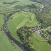
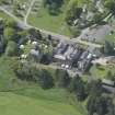
Hoddom Castle


Country House (19th Century), Tower House (16th Century)
Site Name Hoddom Castle
Classification Country House (19th Century), Tower House (16th Century)
Alternative Name(s) Hoddam Castle; Hoddom Castle Policies
Canmore ID 66670
Site Number NY17SE 1
NGR NY 15609 72966
Datum OSGB36 - NGR
Permalink http://canmore.org.uk/site/66670


- Council Dumfries And Galloway
- Parish Cummertrees
- Former Region Dumfries And Galloway
- Former District Annandale And Eskdale
- Former County Dumfries-shire
NY17SE 1.00 15609 72966
(NY 1560 7297) Tower (NR)
OS 1:10000 map (1973)
NY17SE 1.01 15604 72917 Hoddom Castle, Bridge
NY17SE 1.02 15528 72931 Hoddom Castle, Piers (Gate Piers)
NY17SE 1.03 16311 72659 Hoddom Castle, Bridgend Visitor Centre (East lodge)
NY17SE 1.04 16312 72627 Hoddom Castle, Hoddom Bridgend Cottages
NY17SE 1.05 15917 72472 Hoddom Castle, Mains Farm, Cistern House
NY17SE 1.06 1588 7246 Hoddom Castle, Mains Farm Farmhouse; Farmsteading
NY17SE 1.07 1558 7235 to 1559 7328 Hoddom Castle, Foot Bridge (Horse Pool)
NY17SE 1.08 15234 72803 Hoddom Castle, Gardener's House and Hoddom Gardens Cottage
NY17SE 1.09 15772 72495 Hoddom Castle Policies, Park House
NY17SE 1.10 1503 7273 Hoddom Castle Policies, Woodpark Cottage
NY17SE 1.11 1647 7249 Hoddom Castle Policies, Hoddom Saw Mill
NY17SE 1.08 15248 72809 Walled Garden, West Potting Shed
NY17SE 1.08 15259 72814 Walled Garden, East Potting Shed
For West Lodge and gate piers (NY 14878 72966), see NY17SW 34.
For further monuments within Hoddom Castle policies, see:
NY17SE 2 15496 72246 Repentance Tower
NY17SE 12 15505 72236 Trailtrow Chapel
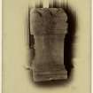
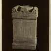
For Roman altar and (later) cross-fragments from the Knockhill summerhouse, which were apparently removed to Hoddom Castle and buried beneath the E drive (apparently at NY c. 1565 7283), see NY17SE 45 and NY17SE 64.
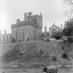
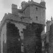
Hoddom or Hoddam Castle: When described in 1965, this tower was derelict, and the modern mansion (of the same name) attached was being demolished. It occupies a strong site, defended by a moat, part of which remained to the S. Built in the 16th century, probably incorporating 15th century work, the building is L-shaped, the main block rising four storeys to the parapet, with a garret above, while the stair wing continues for another two storeys. (See also NY17SE 3 and NY17SE 12 )
RCAHMS 1920, visited 1915; N Tranter 1965
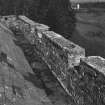
Hoddom Castle is as described. The portion of moat to the SE is 5.0m deep.
Visited by OS (RD) 23 October 1967
No change to previous field report.
Visited by OS (IA) 22 February 1973.
Hoddam belonged to the Herries family of knights who served the Bruces, and then passed to the Carruthers. The massive L-plan tower rising above the River Annan was built by Jihn Maxwell, Lord Herries, soon after he obtained possession in the mid-16th century. It was regarded as a place of some strength but in 1568 an indifferent garrison surrendered the castle to the Regent Moray after a one day siege. He handed it over to Douglas of Drumlanrig to serve as headquarters for the office of Warden of the Scottish West March, but in 1569 Hoddom was recaptured by forces loyal to Queen Mary. In 1570 the English commander Lord Scroop captured and blew up the tower. It was restored, and further remodelling was carried out after Sir Richard Murray obtained Hoddam from the 6th Lord Herries. It passed to the Earl of Southesk in 1653 and to the Sharp family in 1690, and was later held by the Brooks.
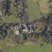
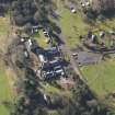
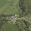
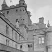
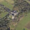
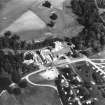
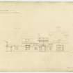
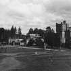
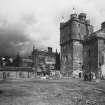
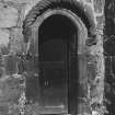
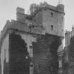
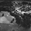
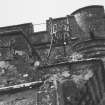
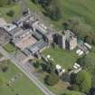
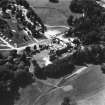
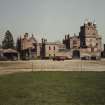
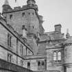
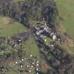
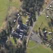
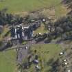
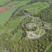
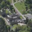
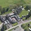
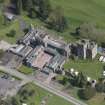
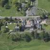
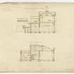
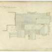
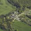
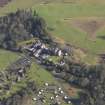
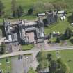
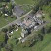
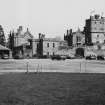
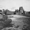
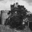
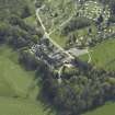
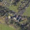
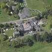
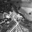
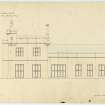
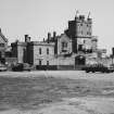
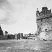
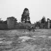
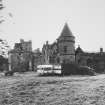
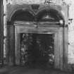
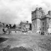
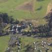
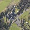
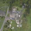
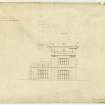
Hoddom Castle now lies derelict on one side of a caravan park. Demolition of a lower later wing has left a scar on the south end wall of the main block, which measures 15.5m by 11m and has four storeys and an attic surrounded by a wall-walk 15.3m above ground. The ornamental coursing carrying the parapet and round bartizans continues round a wing 8.7m wide and 22m high. The wing has two full stories above the coursing and ends in a flat roof with an open bartizan at the SE corner, conical roofed bartizans on the W corners and a higher staircase turret on the NE. Below the foot of the stair is a prison. The entrance doorway has a segmental arch and a bold quirked edge roll moulding with a fillet. the label above the doorway is a big cable with mutilated knotted stops.
There is a much-altered 17th-century courtyard wall on the S and E. Much of the dry moat has now been filled in.
M Salter 1993.
NMRS REFERENCE
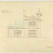
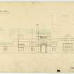
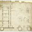
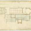
Architect: William Burn, additions and alterations.
Further additions, 1879-91, including Wardrop and Anderson, 1886-88.
Additions and alterations partially demolished.
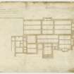
Miscellaneous File: Typescript list of drawings by William Burn in Royal Institute of British Architects' Drawings Collection, London.
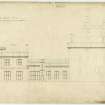
Miss I.H.K. Beattie, architect, Dumfries: sections and elevations of tower, photographs.
(Undated) information in NMRS.
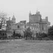
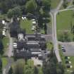
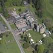
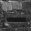
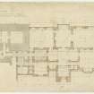
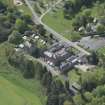
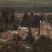
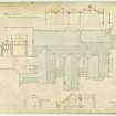
Part of a large asymmetrical mansion, nucleus a fine L-plan 16th century tower house, main (S) courtyard W walls, gateway and turrets largely 17th century; circa 1826 additions by William Burn to S and to W of tower largely demolished circa 1970; extensive neo-Jacobean 1, 2 and 3-storey additions to N and to W built 1878-1891 (dated throughout), some, at least, by Wardrop and Anderson circa 1886; additions mainly comprising open stable court, service ranges to N beyond: now run as a holiday centre for caravan park; tower is abandoned. TOWER: various alterations particularly at upper level and to interior; fantastic skyline probably 18th century. 4 storeys with attic and corbelled parapets, jamb corbelled 2 storeys higher with conical roofed bartizans and 19th century cap-house; parapet encloses slated and crow-stepped-gabled main roof. Massively thick red ashlar walls, openings mostly roll-moulded: deep raggles and door slappings where later ranges abutted. Rope-moulded doorway in re-entrant angle; wide horizontal gunports at ground; some upper floor windows enlarged. (Historic Scotland)
Hoddom has passed through the hands of the Earl of Annandale (17th century), the Earl of Southesk (1653), John Sharpe, Dumfries burgess (1690), Charles Kirkpatrick Sharpe (1769), Lt General Matthew Sharpe (early 19th century), and Edward Brook, Huddersfield mill owner (1877).
Construction (1826 - 1827)
Additions and alterations by William Burn. Measured drawings from 1826-27.
Photographic Survey (1956)
Photographic survey by the Scottish National Buildings Record in 1956.
Publication Account (1986)
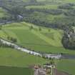
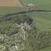
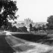
Towering over its courtyard, the huge mass of Hoddom Castle bears the scars, not of war, but of 19th century additions lately demolished. However,long before the castellated additions of 1826-7 were ever thought of, this was a building which had seen real military action, having been vigorously attacked three times within the first few years of its existence. Replacing an older castle on the opposite bank of the river, Hoddom was built by John Maxwell, 4th Lord Herries, shortly before 1568 as his chief residential stronghold on the West March.
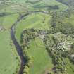
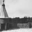
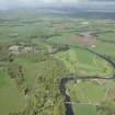
For its date this is a massive structure, standing to a height of over 21.3m with walls 2.7m thick at base. In conception it is akin to older generations of ' power houses' such as Comlongon (no. 37), but externally is distinguished from them in its liberal provision of gun-ports and in the decorative carved treatment of its corbelling and door-surround. Viewed from the caravan park, the later heightening of the turreted wing obscures the castle's highest original feature, a beacon platform corbelled out from the apex of the north gable. The purpose of this was explained in the Border Laws which enjoined that 'ever in war and in peace, the watch to be kept on the house-head; and in war the beacon in the fire-pan to be kept and never fail burning, so long as the Englishmen remain in Scotland; and with a bell to be on the head of the fIrepan which shall ring whenever the fray is, or that the watchman seeing the thieves disobedient come over the Water of Annan, or thereabouts, and knows them to be enemies'.
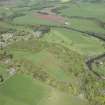
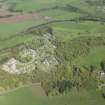
The platform at Hoddom is especially significant because it can be related, uniquely, to a watch tower which stands on the summit of Trailtrow Hill to the south. Compared to its parent in the valley below, this tower is a diminutive oblong structure of three main storeys, but from its vantage point commands a very extensive view of the lower reaches of the Annan and the Solway shore. It too was built by John Maxwell, 4th Lord Herries. 'REPENTENCE' is carved on the door lintel, possibly a token of regret for the fact that it was built out of the remains of a demolished chapel in whose burial-ground it stands.
It was evidently useful. In 1579 Maxwell recommended that 'the watch tower upon Trailtrow, called Repentance, must be mended of the little defacing the English army made of it [probably in 1570]; and ... the great bell and the fire-pan put on it ... '. The parapet was reconstructed in the early 18th century, and the upper floor fitted up as a dovecote, an unconscious symbol of peace and changed attitudes towards the 'Auld Enemy'-or was it?
Information from ‘Exploring Scotland’s Heritage: Dumfries and Galloway’, (1986).
Field Visit (15 October 1993)
NY 1560 7297 NY17SE 1
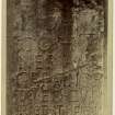
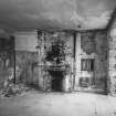
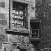
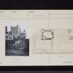
On the second floor, beside a remodelled fireplace in the SSE wall, and not noted in the published Inventory description, there is an aumbry which still retains its original 16th-century oak frame, door and iron fittings. The frame of the door (which comprises four members and a muntin) is morticed, and the tenons are pinned in place with dowels; the two panels are joined by a tongue-and-groove and wrought on the arris with a mitred chamfer. The wrought iron tee hinges and the leaded clasps retaining the butted frame have butterfly terminals while the arms of the two hinges bear mid-length rosette expansions.
Visited by RCAHMS (IMS), 15 October 1993.
Listed as tower, inscriptions and sculptures.
RCAHMS 1997.
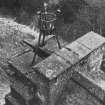
Watching Brief (25 November 2020 - 30 November 2020)
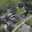
In November 2020, Wardell Armstrong LLP (WA) was commissioned by George Birkbeck to undertake an archaeological watching brief during groundworks occurring in the vicinity of Hoddom Castle, Cumertrees, Dumfries and Galloway (NGR: centred on NY 15609 72966). The groundworks were required to install new services between the castle and a biomass boiler house. An area of archaeological interest had been identified for archaeological monitoring following consultation with Andrew Nicholson, the Local Planning Archaeologist for Dumfries and Galloway.
Information from OASIS ID: wardella2-409233 (A Buschmann) 2020
Note (5 July 2022)
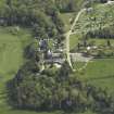
Hoddom Castle was built in the years around 1565 for Sir John Maxwell of Terregles, Lord Herries; at the same time the small tower of Repentance was built on an adjacent hilltop, from where it commanded wide views over the surrounding countryside. Together they formed part of Maxwell's determined campaign to impose order on the West March of Scotland's border with England. The main focus of the castle was the massively constructed tower house, which was retained and adapted when the castle was progressively enlarged to form a very large mansion for the Sharpe and Brook families in the late eighteenth and nineteenth centuries.
The castle ceased to be a residence in the 1930s when it became a youth hostel. Much of the mansion was demolished between the 1950s and '70s, following neglect during wartime requisition, though parts have been retained to serve a modern caravan park adjacent to the castle.
The core of Hoddom Castle is a massively constructed large-scale mid-16th-century residential tower of L-shaped plan. It was rendered yet more imposing when the wing was heightened by an additional two storeys for the first Earl of Annandale in about 1636, who 'greatly improved and increased [the castle] with additional buildings'. The heightening carries the corner turrets upward where they have been roofed with high, conical roofs.
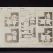
As originally built, the tower was of three principal storeys above a barrel-vaulted basement, and with a garret in the roof space. Up to second -floor level access between the floors is by a spiral stair within the wing, but above that level access is by a smaller spiral stair within the wall thickness at the junction of the main block and the wing. There was originally a single room at each level of the main block, but they were subdivided by a cross wall when the tower was incorporated within a later mansion.
The tower retains a number of highly interesting architectural details, including projecting machicolations at the wall head, fine fireplaces and imposing wide-mouthed gunloops. Of the other buildings once associated with the castle, and known of from early views, a round tower that originally stood at one corner of the main courtyard is the principal survivor. The other buildings were destroyed when the castle was enormously extended to create a mansion of considerable architectural quality, parts of which have been retained to the east and north of the tower.
J Gifford 1966; D MacGibbon and T Ross 1887; A M T Maxwell-Irving 1988; RCAHMS 1920; RCAHMS 197; G Stell 1982
Information from the HES Castle Conservation Register, 5 July 2022

