Pricing Change
New pricing for orders of material from this site will come into place shortly. Charges for supply of digital images, digitisation on demand, prints and licensing will be altered.
Dun Chealamy
Broch (Iron Age)(Possible)
Site Name Dun Chealamy
Classification Broch (Iron Age)(Possible)
Canmore ID 6363
Site Number NC75SW 9
NGR NC 7199 5140
Datum OSGB36 - NGR
Permalink http://canmore.org.uk/site/6363
- Council Highland
- Parish Farr
- Former Region Highland
- Former District Sutherland
- Former County Sutherland
NC75SW 9 7199 5140.
(NC 7199 5140) Dun Chealamy (NAT) Broch (NR)
(Undated) OS map.
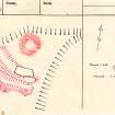
Dun Chealamy, the heavily-robbed remains of a broch (RCAHMS 1911 and OS {JLD}) or dun (Young 1964), situated on the end of a spur and so naturally defended on all sides except the SW, which has an outwork consisting of a double rampart with one (Young 1964) or two (OS {JLD}) ditches. Although the site is mutilated sufficient remains of the wall faces to establish a width of between 3.7m and 4.3m, and an internal diameter of 7.0m. The masonry is poor and no entrance is visible. The ditches are 12.0m broad and 2.0m deep, and both ends of the inner ditch have been built up with stone (Young 1964). The ditch contains the footings of a later structure, 12.0m by 4.0m.
RCAHMS 1911, visited 1909; A Young 1964; Visited by OS (JLD) 6 May 1960.
Dun Chealamy is a broch with out works as described by the previous field investigator. Traces of a mural gallery are exposed in the rubble of the broch in the south-west arc. There are gaps between the natural slopes and either end of the outworks, one or both of which must be an entrance approach; there is no trace of the stone revetting noted by Young (1964).
Visited by OS (N K B) 17 January 1979.
Publication Account (2007)
NC75 4 DUN CHEALAMY ('Dun Kealmie')
NC/7199 5140
Probable broch in Farr, Sutherland, the heavily robbed (“Three years ago” (that is, in 1902 or 1903) “Dun Kealmie was badly damaged in a search of stones for building a bridge and a dwelling house.” (Mackay 1906, 132)) remains of which stand on the end of a spur. The site is thus naturally defended on all sides except the south-west where there is an outwork consisting of a double rampart with either one or two ditches associated with it [1]. Swanson describes two ditches [5, plan].
There are traces of both wallfaces of the circular building within this defence, and these indicate an internal diameter of 7.0m [1] or 9.0m (30ft) [2] or 6.8m from west-south-west to east-north-east [5], and a wall thickness of 3.7 to 4.3m [1] or 4.2m [2]. Traces of a gallery in the wall were noted in 1979 [1] and by 1985 a scarcement had been exposed in the west by stone clearance [5]. There are no signs of the entrance.
Sources: 1. NMRS site no. NC 75 SW 9: 2. RCAHMS 1911a, 60, no. 179: 3. Young 1962, 189: 4. Horsburgh 1867, 272: 5. Swanson (ms) 1985, 730-32 and plan.
E W MacKie 2007
Note (7 February 2015 - 1 June 2016)
This heavily-robbed broch stands on a steep-sided promontory which is defended on the most easily accessible side on the SW by twin ditches with a medial rampart. The broch measures about 7m in diameter within a wall between 3.7m and 4.3m thick, but displays no architectural features. The rampart of the earthwork barring access along the spur from the SW stands up to 2m high above the bottom of the flanking ditches, which are up to 8m in breadth; the inner contains the footings of a rectangular building. The interior is otherwise featureless and defined by no more than the crest of the slope; it measures about 70m from ENE to WSW by 34m transversely (0.11ha). The ditches stop short of the margin of the promontory on both the NW and SE, either of which mat mark the position of an entrance. The relationship between the broch and the outer works is unknown.
Information from An Atlas of Hillforts of Great Britain and Ireland – 01 June 2016. Atlas of Hillforts SC2795


