
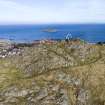
North Berwick Law


Fort (Prehistoric)
Site Name North Berwick Law
Classification Fort (Prehistoric)
Canmore ID 56699
Site Number NT58SE 32
NGR NT 5560 8422
Datum OSGB36 - NGR
Permalink http://canmore.org.uk/site/56699


- Council East Lothian
- Parish North Berwick
- Former Region Lothian
- Former District East Lothian
- Former County East Lothian
Field Visit (1954)
This site was included within the RCAHMS Marginal Land Survey (1950-1962), an unpublished rescue project. Site descriptions, organised by county, are available to view online - see the searchable PDF in 'Digital Items'. These vary from short notes, to lengthy and full descriptions. Contemporary plane-table surveys and inked drawings, where available, can be viewed online in most cases - see 'Digital Images'. The original typescripts, notebooks and drawings can also be viewed in the RCAHMS search room.
Information from RCAHMS (GFG) 19 July 2013.
Reference (1957)
This site is noted in the ‘List of monuments discovered during the survey of marginal land (1951-5)’ (RCAHMS 1957, xiv-xviii).
Information from RCAHMS (GFG), 24 October 2012.
Aerial Photography (March 1971)
Aerial Photography (October 1971)
Field Visit (28 August 1975)
This fort is generally as described.
Visited by OS (SFS) 28 August 1975
Desk Based Assessment (28 August 1975)
NT58SE 32 5564 8422.
(NT 5564 8422) Fort (NR)
OS 6" map (1968)
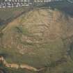
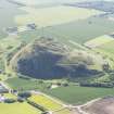
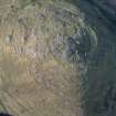
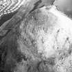
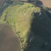
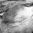
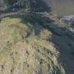
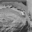
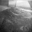
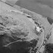
This fort occupies the summit of North Berwick Law (613ft OD). The remains are mostly scanty, much of the material of the dry-built stone walls having toppled down the steep slopes of the hill. An area measuring about 500ft by about 300ft was enclosed by a wall running on a level of some 50ft below the summit. The terrace immediately below this on the SW was likewise enclosed.
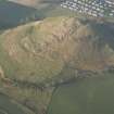
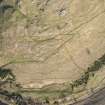
The gentler slope which intervenes between the second wall and the foot of the hill is enclosed by a third wall, several other stretches of which can be seen round the other side of the hill . In this lowest enclosure it is still possible to see the striking remains of numerous circular platforms upon which houses once stood, and several examples of the lowest courses of the stone walls of these (see NT58SE 10).
Information from OS (SFS) 28 August 1975
Source: R W Feachem 1963
Watching Brief (2000)
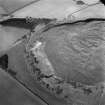
NT 555 839 (centre) A watching brief was carried out during excavation of seven pits for the erection of waymark posts around the Law. No features of archaeological significance were identified.
Desk Based Assessment (2001)
A desk based assessment was undertaken as part of the project.
Sponsors: North Berwick Community Council, East Lothian Council.
C Lowe and J Morrison 2001
Test Pit Survey (2001)
Twelve test pits, 0.5 x 0.5m, were excavated across the area to be planted. No archaeological deposits or finds were encountered.
Full details lodged with the NMRS.
Sponsors: North Berwick Community Council, East Lothian Council.
C Lowe and J Morrison 2001
Archaeological Evaluation (2001)
An archaeological evaluation and watching brief were subsequently carried out on the NE slope of North Berwick Law prior to a programme of tree planting. A hand-dug trench, 6 x 1m, was excavated across a bank, thought to be the boundary of a plantation established in 1707. The profile of the bank was recorded. Two pieces of flint and a copper-alloy buckle were found within topsoil deposits.
Sponsors: North Berwick Community Council, East Lothian Council.
C Lowe and J Morrison 2001
Ground Survey (2001)
A total of 13 sites or groups of sites were identified during the course of the field survey. A detailed plot was made of the later prehistoric settlement (NMRS NT58SE 10) on the S flank of the Law. Previously unrecognised elements of the Napoleonic-period signalling station (NMRS NT58SE 66) on the summit were traced. An element of the early 18th-century plantation on the NE side of the Law was also identified.
Sponsors: North Berwick Community Council, East Lothian Council.
C Lowe and J Morrison 2001
Watching Brief (1 February 2012 - 31 March 2012)
A monitored strip was carried out during all ground breaking work for the upgrading to the lower section of the main access path to the summit of North Berwick Law. The excavation depth rarely fully removed topsoil, although the uppermost sections revealed areas of bedrock outcrop close to the current ground surface. With the exception of a piece of possible worked quartz, and occasional small fragments of unarticulated animal bone and tooth recovered from the topsoil, no artefacts or features of archaeological significance were identified.
Information from Oasis (cfaarcha1-124726) 16 January 2013
Note (3 April 2017)
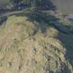
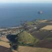
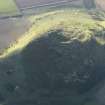
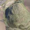
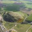
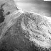
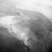
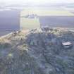
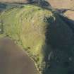
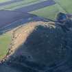
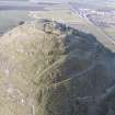
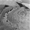
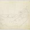
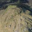
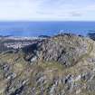
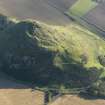
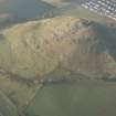
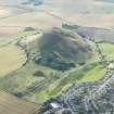
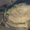
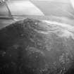
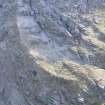
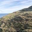
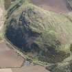
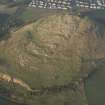
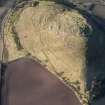
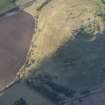
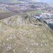
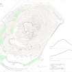
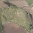
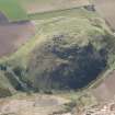
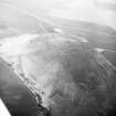
The distinctive cone of North Berwick Law, which rises abruptly above the surrounding countryside from a height of about 65m to its summit at 187m OD, is the site of a large fort. Its defences are fragmentary, according to Richard Feachem, who drew up a plan for RCAHMS in 1954, comprising three ramparts: the first encircles the summit of the hill; the second takes in a lower terrace on the SW; and the third drops down on either flank to enclose the lower slopes on SW, including a broad terrace extending out to the lip of the disused Law Quarry. Feachem notes that the inner rampart encloses an area measuring about 150m from NE to SW by 90m transversely (1963, 119), though there is little trace of it along the rocky NW and SE flanks, and the last sight of the SW side on the SE would suggest a rather large transverse measurement in the order of 135m (1.7ha). The second rampart on the SW is more fragmentary, and while aerial photographs indicate a band of stony debris about 60m further down the slope from the inner, a survey carried out by Headland Archaeology in 2000-1 failed to identify any trace of a rampart here (Lowe and Dalland 2001; archived RCAHMS MS1039/72). The leading edge of the third rampart has been destroyed by the quarry along most of the SW side, but finds from exposures in the quarry revealed midden and other evidence of occupation leading, while on both the W and E the course of the rampart can be followed, forming a terrace climbing obliquely up the slope. The greater part of the interior is bare rock outcrop, but on the lower slopes within the compass of the third rampart, which encloses an overall area of about 9.4ha, a series of hut-circles and house platforms can be seen strung across natural terraces on the lower slopes on the S, while on the gentler slope below them at least two lynchets of a small field-system can also be distinguished. The only entrance visible in the lower rampart lies on the SE, giving access to the lower slopes on the S from the E; the entrances through the upper ramparts are probably marked by clefts in the outcrops taken by modern footpaths. The quarrying at the foot of the slope exposed midden in deposits up to 0.7m deep.
Information from An Atlas of Hillforts of Great Britain and Ireland – 03 April 2017. Atlas of Hillforts -SC3896
Field Visit (February 2018 - May 2018)
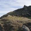
The wasted remains of this fort and its outworks occupy the rocky summit of North Berwick Law. Roughly triangular with rounded corners on plan, it measures internally up to 103m from NE to SW by the same transversely, and the circuit was designed to include slightly flatter ground off to the E and W of the summit boss. The principal line of defence is a single wall (A) now reduced to no more than a light band of rubble about 4m in thickness and 0.6m in external height, which is visible for most of the circuit. The best preserved segment is on the SE where a 5.5m long stretch of outer facing-stones is visible. There is now no obvious indication of where the entrance was located but it is more than likely to have been at the NW corner where the modern path follows a broad and smooth gulley.
Two terraces (B) on the steep ground to the E of the fort are probably the remains of outworks. They lie 14m and 23m E of the main wall respectively, both are accompanied by vestiges of an internal quarry scarp, and both follow the contours, the upper for a distance of at least 60m, the lower in discontinuous stretches for the same distance. One other stretch of wall on the N flank may also be related (C).
Three further outworks were identified by RCAHMS in 1954 and by the OS in 1975. The first of these (NT58SE 162) is probably a boundary bank of much more recent date. The second has been recorded here as the remains of a wall (NT58SE 32.1) of uncertain date. The third (NT58SE 169) has no direct relationship with either the fort or the settlement and may also be of relatively modern date and function.
The interior of the fort is rocky and uneven, and no evidence for contemporary structures have been identified. Indeed, the area is dominated by later features such as the observation post (NT58SE 65) and signal station (NT58SE 66), and there are indications that much of the summit area has been quarried. There is also no evidence to suggest that the fort and the settlement (NT58SE 10) on the terrace to the S are contemporary.
Visited by HES Survey and Recording (GFG, JRS, AM) February 2018 and (GFG, ATW) May 2018
(NBL9.1)

