Pricing Change
New pricing for orders of material from this site will come into place shortly. Charges for supply of digital images, digitisation on demand, prints and licensing will be altered.
Field Visit


Date February 2018 - May 2018
Event ID 1044067
Category Recording
Type Field Visit
Permalink http://canmore.org.uk/event/1044067
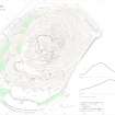
The wasted remains of this fort and its outworks occupy the rocky summit of North Berwick Law. Roughly triangular with rounded corners on plan, it measures internally up to 103m from NE to SW by the same transversely, and the circuit was designed to include slightly flatter ground off to the E and W of the summit boss. The principal line of defence is a single wall (A) now reduced to no more than a light band of rubble about 4m in thickness and 0.6m in external height, which is visible for most of the circuit. The best preserved segment is on the SE where a 5.5m long stretch of outer facing-stones is visible. There is now no obvious indication of where the entrance was located but it is more than likely to have been at the NW corner where the modern path follows a broad and smooth gulley.
Two terraces (B) on the steep ground to the E of the fort are probably the remains of outworks. They lie 14m and 23m E of the main wall respectively, both are accompanied by vestiges of an internal quarry scarp, and both follow the contours, the upper for a distance of at least 60m, the lower in discontinuous stretches for the same distance. One other stretch of wall on the N flank may also be related (C).
Three further outworks were identified by RCAHMS in 1954 and by the OS in 1975. The first of these (NT58SE 162) is probably a boundary bank of much more recent date. The second has been recorded here as the remains of a wall (NT58SE 32.1) of uncertain date. The third (NT58SE 169) has no direct relationship with either the fort or the settlement and may also be of relatively modern date and function.
The interior of the fort is rocky and uneven, and no evidence for contemporary structures have been identified. Indeed, the area is dominated by later features such as the observation post (NT58SE 65) and signal station (NT58SE 66), and there are indications that much of the summit area has been quarried. There is also no evidence to suggest that the fort and the settlement (NT58SE 10) on the terrace to the S are contemporary.
Visited by HES Survey and Recording (GFG, JRS, AM) February 2018 and (GFG, ATW) May 2018
(NBL9.1)