
Drem, The Chesters


Fort (Prehistoric)
Site Name Drem, The Chesters
Classification Fort (Prehistoric)
Canmore ID 56280
Site Number NT57NW 1
NGR NT 50760 78260
Datum OSGB36 - NGR
Permalink http://canmore.org.uk/site/56280


First 100 images shown. See the Collections panel (below) for a link to all digital images.
- Council East Lothian
- Parish Athelstaneford
- Former Region Lothian
- Former District East Lothian
- Former County East Lothian
Field Visit (31 March 1914)
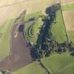
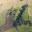
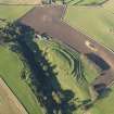
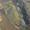
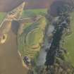
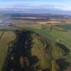
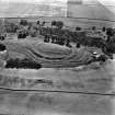
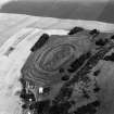
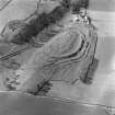
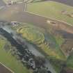
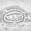
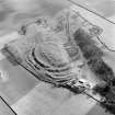
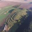
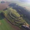
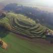
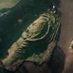
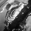
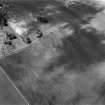
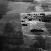
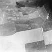
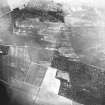
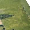
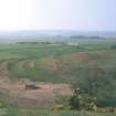
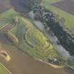
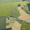
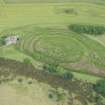
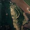
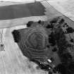
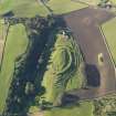
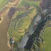
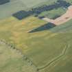
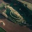
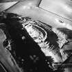
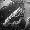
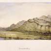
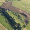
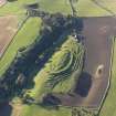
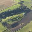
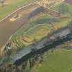
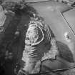
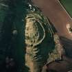
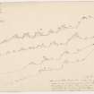
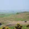
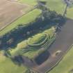
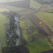
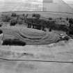
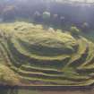
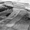
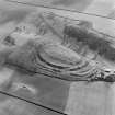
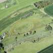
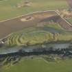
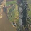
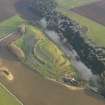
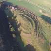
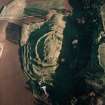
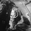
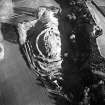
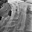
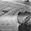
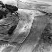
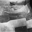
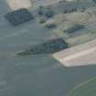
Some ¾ mile south-south-west of Drem Station, at an elevation of over 200 feet above sea-level and overlooking the plain stretching northwards to the Forth, is a narrow ridge, steep on the sides but sloping more gently towards the ends. About 50 yards to the south is a sharp bluff, which overtops it by more than 50 feet. The ridge, which rises from 40 to 50 feet above the general level, runs east and west, and is occupied by a fine fort, oval on plan, measuring about 390 feet in length and 160 feet in breadth internally (fig. 47). It is defended by an elaborate series of ramparts of stone and earth erected on the slopes of the ridge; these are well preserved at the west end (fig. 13) but much dilapidated on the flanks and at the eastern extremity. The defences consist of two ramparts entirely encircling the fort with further external lines of walling, which vary in number at different parts. Outside the two inner walls are three others on the northern flank, one on the southern flank, five short mounds across the western end, and to the east a series of short curvilinear breastworks (fig. 48). Thus there are five lines of defence to the north, covering a distance of about 180 feet in width, three to the south over a space of 95 feet and seven at the east and west ends. There are two entrances, from the north-west and from the east. The north-west entrance is carried diagonally through the outer defences in a south-easterly direction till it meets the second wall from the inside, where it turns sharply to the south between an overlap in this defence, at which place the roadway is14 feet wide; it then turns east and enters the interior through a gap in the inner wall 16 feet wide. The eastern entrance is along the gradually sloping crest of the ridge; its width where it passes the second inner wall is 15 feet. In the interior of the fort traces of the foundations of a large number of circular stone buildings remain. They vary in size from 15 to 40 feet in diameter and occur chiefly along the inside of the inner wall. In the New Statistical Account of the parish it is stated, for a time (1835) when these remains were probably more clearly marked, that ‘The houses, the foundations of which are still obvious, had been built round the sides of the summit in regular rows, and the greater part in a conical form. In the centre are the foundations of oblong houses of larger dimensions. The conical houses are generally 12 feet in diameter within the walls’.
RCAHMS 1924, visited 31 March 1914.
Measured Survey (12 October 1920)
RCAHMS surveyed the fort at Chesters on 12 October 1920 using plane-table and alidade at a scale of 1 in. to 60 ft (1:720). The plan and sections were redrawn in ink and published at a reduced scale (RCAHMS 1924 Fig. 47).
Field Visit (30 October 1956)
Fort, The Chesters, Drem (Inv. No. 13).
The hut circles are definately later than the fortifications since those round the perimeter impinge upon the inner rampart of the fort as shown on the plan. Otherwise, the description given in the Inventory is adequate.
Visited by RCAHMS (KAS) 30 October 1956.
Field Visit (22 July 1975)
A multivallate fort as described. The two inner ramparts have a maximum height of 5.0m where best preserved on the NW. The outer ramparts survive to a height of 3.5m.
Visited by OS (BS) 22 July 1975.
Desk Based Assessment (1975)
NT57NW 1 50760 78260
(NT 5076 7826) The Chesters (NAT) Fort (NR)
(Unspecified) OS map.
Although on plan The Chesters would seem to belong among the larger and better preserved hill-forts in the country, it stands on a very low ridge immediately under the lee of a precipitous scarp 50' high from which missiles could easily be directed into the interior.
Apart from this anomaly, the fort represents a type of multivallate work, the innermost defended zone of which is bordered by a whole series of ramparts and ditches, and there is reason to believe that the existing visible remains may represent parts of more than one phase of construction. The innermost enclosure measures 380' by 150' within a ruinous rampart appearing for the most part as a mere scarp. This is surrounded by another rampart, and thereafter by traces of up to six others. The external measurement of the whole structure is 900' by 500'. (See RCAHMS 1924 plan, fig.47).
The interior contains the surface traces of several circular stony foundations which vary in size. Certain of them overlie the ruined defences, an indication that they represent a period of occupation subsequent to the time when the ramparts were in use and probably dating from the 2nd or later centuries AD.
Sources: R W Feachem 1963; RCAHMS 1924, visited 1914.
Watching Brief (1976)
Work has begun on removing Second World War constructions from the monument. They consist of an observation post and several gun-emplacements. In removing the former, which was situated in the centre of the fort, vestigial traces of two walls appeared which might pertain to the hut circle marked at this spot by the RCAHMS prior to the erection of the post. No attempt, however, was made to excavate any more than necessary. The removal of one of the gun-emplacements, situated on top of the inner rampart on the N side of the E entrance to the fort, gave an opportunity of examining the partial section through the rampart. There was no sign of revetting within the bank and no tip lines were visible. There were no finds of any importance.
M J Yates 1976.
Publication Account (1985)
Through this fort occupies the greater part of a long, oval hillock, it is relatively low-lying and overlooked by a higher ridge from which missiles could easily have been launched. Vulnerability would not have mattered perhaps in its earlier periods of occupation; gradually, however, fortifications were extended providing a most elaborate system of stone and earth ramparts. Was it simply a case of a wealthy community wanting to impress? Or to present an illusion of strength to would-be attackers?
Two ramparts entirely encircle the site; to the north there are a further three lines of banking, spanning 55m. A series of five earthworks stretches across the west end, with a further series to the east, and these may have been intended specifically to protect the entrances at the north-west and east of the fort.
The enclosed area measures some 119m by 49m, within inner ramparts still standing to over 2m high. Inside, there are traces of the foundations of maybe 20 or 30 mainly circular stone buildings varying in size from 4.25m to 12m diameter but apparently ranged around the sides in roughly regular rows. Some overlie the ramparts, thus suggesting a period of occupation from the 2nd century AD or later.
Information from 'Exploring Scotland's Heritage: Lothian and Borders', (1985).
Ground Survey (August 2010)
NT 50760 78260 As part of ongoing research into East Lothian hillforts a topographic and erosion survey was undertaken in August 2010. The survey was carried out by volunteers and students following a programme of gorse removal. The initial results of the survey indicate that, while the site has suffered from rabbit burrowing and stock pressure in the past, it is currently stabilising and recovering. The topographic survey of the upper enclosed area has created an accurate plan of the interior, plotted the locations of WW2 installations removed
in the 1970s and located a possible new entrance to the N.
Archive: RCAHMS (intended)
Funder: Historic Scotland and Rampart Scotland
David Connolly and Murray Cook – Rampart Scotland
Geophysical Survey (August 2011)
NT 50760 78260 Geophysical survey.
Archive: RCAHMS (intended)
Funder: Historic Scotland and Rampart Scotland
Rampart Scotland 2011
Project (September 2012)
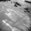
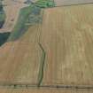
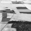
NT 504 782 – NT 506 784 (approx) The Chesters, Drem (SAM 90072) is one of the best preserved Iron Age hillforts in Scotland and is protected both by scheduling and as a PIC. However, the upstanding remains form just one element of an extensive Iron Age landscape evidenced by cropmarks identified through many years of aerial survey. Most notably, these comprise an extensive series of pit alignments which appear to reflect a cohesive system of land division potentially extending up to 5km2, and reaching as far as neighbouring hillforts at Kae Heughs (NT57NW 23) and Hanging Craig (NT57NW 89). Our project involves geophysical evaluation of these landscapes using a range of integrated and complementary techniques including standard fluxgate gradiometry and earth resistance survey. We also trialled two novel techniques currently under development and not previously used to any extent in Scotland: electrical resistivity tomography and electromagnetic survey. Gradiometry was used as the baseline technique to recover broad scale information and give wide coverage across the sites, with other techniques being used in targeted areas based on initial results and detailed field inspection.
Results from work in September 2012 were generally positive and identified the cropmark features in most areas. Several new features have been identified, including at least one probable barrow, but more significant perhaps is the new data retrieved relating to the micro-topography of the pit alignment systems and the detailed relationships between these archaeological features and the local geology.
Archive: RCAHMS (intended). Reports: East Lothian SMR and RCAHMS (intended)
Funder: Historic Scotland
Ian Armit, University of Bradford
Chris Gaffney,
Tom Sparrow,
Finn Pope-Carter,
2012
Magnetometry (September 2012)
NT 504 782 – NT 506 784 (approx) The Chesters, Drem (SAM 90072) Fluxgate gradiometry was used to investigate this extensive Iron Age landscape.
Archive: RCAHMS (intended). Reports: East Lothian SMR and RCAHMS (intended)
Funder: Historic Scotland
Ian Armit, University of Bradford
Chris Gaffney,
Tom Sparrow,
Finn Pope-Carter,
2012
Electromagnetic (September 2012)
NT 504 782 – NT 506 784 (approx) The Chesters, Drem (SAM 90072) Electromagnetic survey techniques were used to investigate this extensive Iron Age landscape.
Archive: RCAHMS (intended). Reports: East Lothian SMR and RCAHMS (intended)
Funder: Historic Scotland
Ian Armit, University of Bradford
Chris Gaffney,
Tom Sparrow,
Finn Pope-Carter,
2012
Electrical Resistivity Tomography (September 2012)
NT 504 782 – NT 506 784 (approx) The Chesters, Drem (SAM 90072) Earth resistance survey and electrical resistivity tomography techniques were used to investigate this extensive Iron Age landscape.
Archive: RCAHMS (intended). Reports: East Lothian SMR and RCAHMS (intended)
Funder: Historic Scotland
Ian Armit, University of Bradford
Chris Gaffney,
Tom Sparrow,
Finn Pope-Carter,
2012
Field Visit (September 2012 - November 2012)
NT 50760 78260 As part of ongoing research into East Lothian hillforts further topographic and erosion survey was undertaken between September and November 2012.
Archive: RCAHMS (intended)
Funder: Rampart Scotland
David Connolly, Rampart Scotland
Murray Cook,
2012
Field Visit (September 2013 - November 2013)
NT 50760 78260 As part of ongoing research into East Lothian hillforts, further topographic and erosion survey was undertaken, September – November 2013. The site is stable; however, gorse regrowth is ongoing.
Archive: RCAHMS (intended)
Funder: Rampart Scotland
David Connolly and Murray Cook, Rampart Scotland, 2013
(Source: DES)
Field Visit (March 2014 - July 2014)
NT 50760 78260 As part of ongoing research into East Lothian hillforts, further topographic, erosion and limited geophysical survey was undertaken, March – July 2014. The work was undertaken with volunteers and students as part of a series of training sessions.
Archive: RCAHMS (intended)
Funder: Historic Scotland and Rampart Scotland
David Connolly and Murray Cook – Rampart Scotland
(Source: DES)
Note (15 December 2015 - 18 May 2016)
The well-known fort known as The Chesters at Drem is situated on a relatively low-lying ridge of rock, which is entirely overlooked by higher ground no more than 100m to the S. The defences are evidently complex, but no clear sequence can be established by survey alone, other than that the innermost rampart, which encloses an oval area on the summit of the ridge measuring about 110m from E to W by 50m transversely (0.47ha), is overlain by a settlement of stone-founded hut-circles and small yards that sprawl across the interior. Whether this rampart, however, was ever used in conjunction with the second rampart, which forms a concentric enclosure of some 0.96ha around it, is quite unknown. Up to four ramparts and ditches can be seen beyond this second line, forming a belt of defences in excess of 40m deep, but they do not form consistently concentric circuits, appearing and disappearing around the ends and northern flank, and entirely missing in the bottom of the gully on the S; almost certainly they represent several periods of construction, and some of the short segments at the E end are either hornworks to provide additional protection to the entrance here, or fragments of an earlier enclosure overlain by the second rampart. This has certainly been a major entrance, the route from the outermost rampart to the innermost covering a distance of some 70m between the terminals of up to six separate lines of defence. A second entrance at the W end is more elaborate still, the present track mounting the slope obliquely from the W before turning sharply back on itself through a gap in the second rampart with overlapping terminals, thus exposing the visitor's left side. A third gap on the S appears more recent, though it may have served the later settlement in the interior.
Information from An Atlas of Hillforts of Great Britain and Ireland – 18 May 2016. Atlas of Hillforts SC3872
Excavation (13 February 2017)
NT 5086 7830 (centred on) Four small trenches were excavated, 13 February 2017, to accommodate the posts of a new rabbit-proof fence in the vicinity of Chesters Hillfort. The hand dug trenches each measured 0.3 x 0.3m by 0.5m deep.
Trench 1 (NT 5091 7824) revealed heavily-rooted topsoil.
Trench 2 (NT 5091 7828) was the only one which reached natural subsoil and it produced a surprising mass of stones, which may indicate the top of the ridge has never been ploughed.
Trench 3 (NT 5090 7832) was at the base of the ridge, and produced a single homogenous deposit, probably a cultivated soil, with far fewer stones than in Trench 2.
Trench 4 (NT 5084 7834) was in a seemingly disturbed area, close to the remains of a building and a track, and this impression was borne out by the amount of relatively recent finds recovered.
Archive: NRHE (intended)
Funder: Historic Environment Scotland
David Murray – Kirkdale Archaeology
OASIS ID: kirkdale1-310553
(Source: DES, Volume 18)
Project (August 2019)
NT 50819 78274 A geophysical survey was carried out at Chesters Hill Fort (Canmmore ID: 56280) in August 2019, as part of a programme of research to increase the understanding of the hill fort and the wider landscape. Gradiometer, resistance and ground penetrating radar (GPR) surveys were undertaken across the central platform of the site, 0.55ha. Additional GPR transects were collected at various locations across the defensive earthworks.
All the survey techniques have recorded anomalies of archaeological interest. The individual data sets are not particularly coherent across the whole survey area but, when viewing the combined interpretation, it is clear that many potential features have been recorded which show good correlation with LiDAR data. It is clear that the different techniques are detecting different elements of the potential structures.
The gradiometer survey has revealed a relatively high level of background response typical of results on this type of geology. Within this generally elevated level of background response, broad areas of increased response have been noted which may be archaeologically significant. Several large coherent positive and negative magnetic anomalies have been noted within the broader areas of increased response. While these may be archaeologically significant, they are not particularly coherent and do not show clear correlation with the earthworks.
The resistance and GPR survey have detected numerous discrete anomalies which are likely to indicate structures and correspond well with the LiDAR data. Additional anomalies have been recorded which do not readily correspond with the LiDAR plot suggesting the potential for different phases of settlement.
Archive: NRHE
Funder: Historic Environment Scotland
Dr Susan Ovenden - Rose Geophysical Consultants
(Source: DES Vol 20)
Magnetometry (August 2019)
NT 50819 78274 Gradiometer survey.
Archive: NRHE
Funder: Historic Environment Scotland
Dr Susan Ovenden - Rose Geophysical Consultants
(Source: DES Vol 20)
Ground Penetrating Radar (August 2019)
NT 50819 78274 GPR survey.
Archive: NRHE
Funder: Historic Environment Scotland
Dr Susan Ovenden - Rose Geophysical Consultants
(Source: DES Vol 20)
Earth Resistance Survey (August 2019)
NT 50819 78274 Resistance survey.
Archive: NRHE
Funder: Historic Environment Scotland
Dr Susan Ovenden - Rose Geophysical Consultants
(Source: DES Vol 20)

