
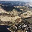
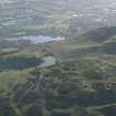
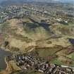
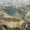
Edinburgh, Holyrood Park, Dunsapie


Field Boundary (Period Unassigned), Fort (Later Prehistoric)
Site Name Edinburgh, Holyrood Park, Dunsapie
Classification Field Boundary (Period Unassigned), Fort (Later Prehistoric)
Alternative Name(s) The King's Park; Queen's Park; Dunsapie Crag; Dunsapie Loch
Canmore ID 52510
Site Number NT27SE 49
NGR NT 28172 73166
Datum OSGB36 - NGR
Permalink http://canmore.org.uk/site/52510


- Council Edinburgh, City Of
- Parish Edinburgh (Edinburgh, City Of)
- Former Region Lothian
- Former District City Of Edinburgh
- Former County Midlothian
NT27SE 49.00 2818 7315
NT27SE 49.01 2818 7315 stone mould
See also NT27SE 102.
(NT 2818 7315) Dunsapie (NAT) Fort (NR)
OS 6" map, (1966)
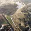
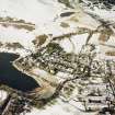
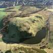
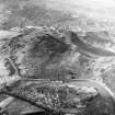
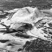
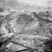
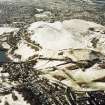
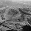
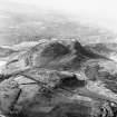
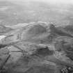
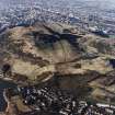
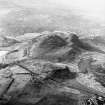
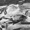
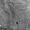
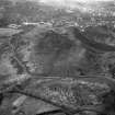
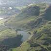
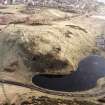
(Location cited as NT 282 731). The remains of this fort crown the rocky hill which borders the E side of Dunsapie Loch. The walls have been most severely robbed of stone, but sufficient remains to show that originally the summit of the hill was bordered by a wall and the E flank by another. Whether they were contemporary might be determined by excavation, but there is no reason to suppose that they were not. The summit area measures about 350 ft [107m] by a maximum width of 200 ft [61m], being bordered on the W and N by precipitous crags and on the other sides by the spread remains of the inner wall. The outer wall is visible below the steep crags bordering the W margin of the summit, running thence S and E round the prolonged E toe of the hill, where the entrance lies. It runs NW from this, rising up the margin of the toe of the hill, until at a point 200 ft [61m] SE of the NE angle of the summit enclosure, it fades away as its line is replaced by steep crags. Several platforms in in the E part of the interior lying between the outer and inner walls suggest stances for Early Iron Age timber-framed houses.
R W Feachem 1963.
The fragmentary remains of a fort occupy the top of Dunsapie Crag. The crag declines in a steep grassy slope to the E, but is precipitous in other directions. A wall ran near the edge of the more precipitous parts, where it is now represented chiefly by footings and small stones, and along the top of the E slope, where it forms in places quite a massive bank. A pear-shaped area some 350' x 200' is enclosed. From the NE corner, a horn-work seems to have run downhill to crown a shoulder of rock: footings indicate a wall 9' thick. The shoulder overlooks a path which may therefore mark the original approach.
An outer wall is visible below the steep crags bordering the W margin of the summit, running thence S and E round the prolonged E side of the hill. It runs NW from this, rising up the margin of the toe of the hill until, at a point 200' SE of the NE angle of the summit enclosure, it fades away as its line is replaced by steep crags. Whether this wall and that on the summit were contemporary might be determined by excavation, but there is no reason to suppose that they were not (Feachem 1963). The outer wall thus forming a large annexe E of the fort. The entrance through the outer wall is in the NE, close to that of the inner. The only other gap in the outer wall is the demonstrably secondary entrance to the scooped enclosure noted on NT27SE 145.
Several platforms in the E part, between the outer and inner walls suggest stances for Early Iron Age timber-framed houses (Feachem 1963). The summit area is divided into three small areas by slightly different natural levels. That to the N is the largest and roughly circular. From a kitchen midden on it came a stone mould for casting rings and brooches, shells, animal bones, vitrified matter etc, which were donated to the NMAS in 1872 (Acc Nos: HR 15 - 39). The vitrified matter seems to have been the result of numerous fires kindled here and there over the area (PSAS 1873).
The other two summit levels are crescentic in form.
Proc Soc Antiq Scot 1873; R B K Stevenson 1949; RCAHMS 1951; R W Feachem 1963; R W Feachem 1965.
The fragmentary remains of this fort are generally as described. The entrance is in the NE. Internally numerous platforms may represent the sites of houses too indistinct for survey. A platform 12.0 x 8.0m exists in the S angle.
Surveyed at 1:2500.
Visited by OS (S F S) 9 December 1975.
Field Visit (27 April 1922)
Fort, Dunsapie.
The mass of eruptive rock that rises at its western base 90 feet above Dunsapie Loch is surmounted by the fragmentary remains of a fort. The rock declines in a steep grassy shoulder to the east but in other directions is precipitous. On the summit are scanty remains of a stone wall, which returns eastwards from the cliff on the north to the southern cliff and encloses an area rather under 100 yards in length and 50 yards in breadth, divided into three small areas by slightly different natural levels. The northern is the largest and is roughly circular; in it was found a stone mould for casting rings and brooches, now in the National Museum of Antiquities. The two other divisions are crescentic in form.
RCAHMS 1929, visited 27 April 1922.
OS map: iii N.E. (unnoted).
Project (February 1996)
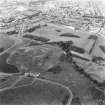
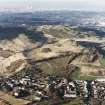
A cultural heritage survey was undertaken by the Centre for Field Archaeology, University of Edinburgh in February 1996 (Alexander 1997) on behalf of (the former) Historic Scotland. The assessment was designed to identify and evaluate the archaeological remains present within Holyrood Park, through the examination of desk-based sources and a field inspection. The results of this work demonstrated that the archaeological potential of Holyrood Park is high, with archaeological remains ranging in date from the Mesolithic to the present. A large number of sites were already recorded within the park but the 1997 survey listed all of these with the addition of many new sites. One notable find was the extensive field banks which run across Whinny Hill. Erosion of archaeological features throughout the park was recorded to be localised and small scale, mostly as a result of footpath wear.
The field survey assessed the nature and extent of erosion affecting the archaeological
remains, identified areas of likely archaeological importance, and made recommendations for managing the erosion and highlighted areas for detailed survey.
The report noted that most of the more serious threats to sites came from recreational use of the Park causing erosion, with the overall effect of erosion not appearing to be great except at specific points. It was noted that while it was difficult to determine how much erosion has occurred since the features were first identified, the archaeological detail described by Stevenson, and shown on a number of his plans, suggested that there had been a general decline in the definition of archaeological remains.
Alexander 1997
Field Visit (15 December 1998)
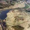
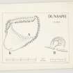
The defences of this fort are depicted at 1:5,550 on an archaeological map of Holyrood Park (RCAHMS 1999). The innermost line of defence encloses a pear-shaped area, and is defined for the most part by the footings of a stone wall extending along the edge of the precipitous crag, but on the E, where the ground drops less steeply, by a substantial grass-grown stony bank measuring 4m in thickness and up to 1m in external height. On the NE, a 4m break in the wall marks the position of the entrance, and coincides with the point through which a later field-bank extends SE down the slope (this field-bank may belong to the field-system described under NT27SE 3938). A row of four facing-stones set back a short distance from the NW angle of the crag probably belong to the inner face of the wall. Rock outcrops divide the interior into three levels, but no structures are visible within any of them.
An additional line of defence is visible below the wall on the W, where a stony scarp can be traced between two rock outcrops. On the E, there are also possible traces of an annexe occupying the gently sloping area dropping down from the wall. The N and S sides of the annexe are mainly defined by low outcrops, but a possible bank extends along the crest of the outcrop on the S and cuts northwards across the slope on the E immediately above an area of cultivation terraces (NT27SE 102). Here the annexe appears to overlie the lower side of a scooped settlement (NT27SE 145), although the entrance to the settlement forms a marked gap in its line. There are several other breaks in the annexe wall, some of which may be relatively modern and the result of erosion by footpaths. Within the annexe, several vague platforms can still be seen, none of which appear to be anything more than a small quarry scoop. The existence of the annexe can only be confirmed by excavation.
Visited by RCAHMS (ARG), 15 December 1998.
NMRS, MS/726/96 (41-2, no. 16); RCAHMS 1999.
Note (8 November 2015 - 18 May 2016)
This fort is situated on the broad summit of Dunsapie overlooking Dunsapie Loch, a location girt with cliffs and rocky escarpments around three sides and easily accessible only from the sloping E flank. Irregular on plan, the fort appears to have been roughly tailored to the margins of the summit area, measuring internally about 135m in length and contracting from about 65m transversely at the N end to 35m at the S end, but the rampart itself has been very heavily robbed and is difficult to follow. At one point on the NW a row of four stones that may belong to the inner face can be seen, but elsewhere no more than wall core is visible, on the W forming a low scarp and petering out at the S end to reappear and on the E as a bank 4m thick by 1m high; a marked re-entrant in its E side, however, suggests that the perimeter may not be all of a piece, and has perhaps been extended southwards from an original enclosure on the northern and higher end. If so the interior on the S, which gives the impression that it is divided into two courts, is perhaps the remains of a late Iron Age settlement overlying the fort, rather than the fort itself. The only evidence of an entrance is on the NE into the upper end of the fort and is obscured by a later field-bank which mounts the slope obliquely to terminate on the edge of the cliff on the N. Traces of an outer rampart can be seen on the W, while on the E there has possibly been an annexe, though the greater part of it is defined by natural features and the lower end is probably partly, if not wholly, formed as a lynchet on the slope. An oval late Iron Age settlement enclosure is scooped into the slope at the lower end of this supposed annexe, and though the relationship between them is unclear its entrance opens through a break in this lynchet. Any connection between the features interpreted as the annexe and the fort is tenuous at best, and they are probably better considered in the context of a succession of land-use systems exploiting this slope rather than as a subsidiary enclosure of the fort. Finds from the area of the fort include a stone mould and a hoard of three Early Bronze Age flat axes.
Information from An Atlas of Hillforts of Great Britain and Ireland – 18 May 2016. Atlas of Hillforts SC3716
Condition Survey (12 March 2018 - 15 April 2018)
The 2018 CFA Archaeology Ltd condition survey found the site as previously described. There are a great number of pathways crossing the site and gorse cover especially on the summit and eastern side of the hill. No molehills were noted.
Information from Graeme Carruthers (CFA Archaeology Ltd) July 2018. OASIS ID: cfaarcha1-317194, no.16
Archaeological Evaluation (August 2022 - September 2022)
NT 282 731 A programme of excavation was undertaken at Dunsapie Fort, Holyrood Park, during August and September 2022, as a university training exercise on behalf of Historic Environment Scotland and University of Edinburgh. The project aimed to evaluate the extent, character and vulnerability of the archaeological resource at Dunsapie Fort.
Five trenches were excavated, three investigating the enclosure on the upper terraces of the fort and two investigating the scooped settlement and underlying annexe rampart to the E of the fort.
The summit trenches demonstrated the variable survival of the remains of the hillfort, with well-preserved deposits and structures surviving in hollows on the summit, much of this area of the fort has however been heavily impacted and truncated. Despite the variable survival significant features were recorded on the summit plateau of the hillfort with sections recorded through the ramparts and two structures internal to the ramparts investigated.
The two trenches investigating the scooped settlement were not fully excavated in this phase of the project and will be returned to in subsequent years.
Archive: NRHE (intended)
Funder: University of Edinburgh and Historic Environment Scotland
Jamie Humble – AOC Archaeology Group
National Museums Scotland catalogue
National Museums Scotland catalogue
National Museums Scotland catalogue
National Museums Scotland catalogue
National Museums Scotland catalogue
National Museums Scotland catalogue
National Museums Scotland catalogue
National Museums Scotland catalogue
National Museums Scotland catalogue
National Museums Scotland catalogue
National Museums Scotland catalogue
National Museums Scotland catalogue
National Museums Scotland catalogue
National Museums Scotland catalogue
National Museums Scotland catalogue
National Museums Scotland catalogue
National Museums Scotland catalogue
National Museums Scotland catalogue
National Museums Scotland catalogue
National Museums Scotland catalogue
National Museums Scotland catalogue

