
Castle Knowe


Palisaded Enclosure (Prehistoric), Rig And Furrow (Medieval) - (Post Medieval)
Site Name Castle Knowe
Classification Palisaded Enclosure (Prehistoric), Rig And Furrow (Medieval) - (Post Medieval)
Canmore ID 51873
Site Number NT26SW 21
NGR NT 2299 6404
Datum OSGB36 - NGR
Permalink http://canmore.org.uk/site/51873


- Council Midlothian
- Parish Glencorse
- Former Region Lothian
- Former District Midlothian
- Former County Midlothian
NT26SW 21 2299 6404.
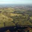
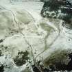
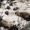
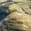
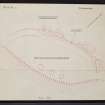
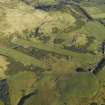
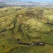
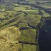
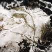
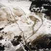
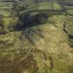
NT 22996404. On Castle Knowe, a knoll from which the ground falls steeply from the S and W but is easily approached from N and E, there are the slight remains of earthworks possibly representing two phases of occupation.
The first phase may consist of a palisade trench appearing as a shallow groove about 0.6m in width, almost completely obliterated by later cultivation, enclosing an area 77m NE-SW by 32m transversely, within which are traces of three timber houses of ring-groove type.
Outside the palisade trench, and running parallel to it at an average distance of 6.0m, a marker trench can be traced continuously except for a distance of 16m at the SW end where it has been obliterated by later cultivation. Intermittent quarry-ditches and a spread inner bank occur on the N and E together with a gap on the NE, probably an original entrance. The incomplete nature of this work clearly indicates that it was never finished.
Surveyed at 1:2500. See also 1/500 enlargement.
Visited by OS (JP) 26 March 1971
No change to previous field report.
Visited by OS (BS) 9 December 1975
Photographed by the RCAHMS in 1980.
Fort [NR] (unfinished) [NAT]
OS 1:10,000 map, 1983.
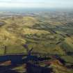
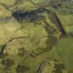
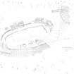
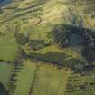
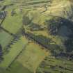
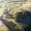
This palisaded enclosure is situated on a prominent knoll above and only 100m NE of the Castlelaw fort (NT26SW 2). Oval on plan, the enclosure measures at least 73m from ENE to WSW by 34m transversely within two palisade trenches set roughly 6m apart. While the respective courses of these narrow and very shallow trenches can be traced around the WSW end of the knoll, most of the ENE end has been obliterated by rig-and-furrow cultivation (NT26SW 117). Much of the line of the outer palisade trench on the NE and NNW is masked by spoil from broad trenches (up to 0.6m in depth) associated with the use of the site for military training. No trace of any palisade can be seen on the SSE, where the line would have traversed a steep slope that has been heavily disturbed by rabbits.
Although the rig-and-furrow has encroached into enclosure on the ENE, most of the interior appears to be relatively undisturbed and a row of three circular timber buildings (CDTA05 240-2) is visible, cut into the SSE side of the summit, close to the lip of the steep scarp that forms this flank of the knoll. Measuring up to 8m in diameter, the backs of the buildings are visible as arcing scarps, but one at least has an apron at the front. What may be a fourth circular building (CDTA05 243) is marked by a short length of scarp in the WSW part of the interior.
(CDTA05 240-243)
Visited by RCAHMS (JRS) 7 June 2005
Note (1988)
Castle Knowe NT 2299 6404 NT26SW 21
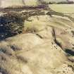
This palisaded settlement is situated on the shoulder of the hill overlooking Castle Law fort (NT26SW 2) from the NE. On the Sand W, where the ground falls steeply, no traces of any defence survive, but on the N two palisade trenches are visible, set about 6m apart. The interior measures 70m by at least 30m, and at the top of the steep slope on the S the positions of at least three timber houses are marked by small platforms. Part of the outer palisade trench is obscured by the upcast from slit-trenches dug during military exercises. On the NE, however, the line of the palisade is continued by a low bank, with an external ditch and a counterscarp bank at its E end; while this latter feature may be an unfinished defensive work, it may also be explained as an attempt to enhance the defences of the entrance, which was probably at this end of the settlement. Evidence of later activity on the site is provided by rig-and-furrow cultivation, which has obliterated part of the perimeter on the E; there is also a short length of ditch and bank some 30m to the NE.
RCAHMS 1988
(Feachem 1971, 30)
Note (6 November 2015 - 18 May 2016)
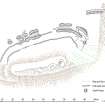
Earthworks on the crest of Castle Knowe, which overlooks the fort at Castle Law (Atlas No.3710), have been claimed to be the remains of an unfinished fort (Feachem 1971, 30), comprising a marker trench and partly-dug segments of ditch with an internal bank, but detailed planning in 1981 revealed the scuffed tracks of tracked vehicles turning across the western segments of the ditch, which also contain a series of sharply rectangular cuts on plan; there is a strong possibility that some of these elements were created for military training exercises. Nevertheless, within the area enclosed by these works there are also traces of a palisaded enclosure, its trench extending round the WSW end of the hillock and up the NNW flank to disappear beneath later cultivation rigs at the ENE end. Oval on plan, it measures about 70m from ENE to WSW by 30m transversely (0.2ha), and contains at least three small platforms set along the lip of the steep SSE flank of the hillock, two of which have shallow encircling shelves cut into the slope at the rear and almost certainly mark the positions of timber round-houses. The existence of this palisaded enclosure on the hillock, however, may also indicate that the military interventions have adapted and modified a pre-existing earthwork, and it is notable that despite its sharp profile, the feature identified as the marker trench, which appears stratigraphically earlier than the segments of earthwork, lies concentric to the palisade trench in the interior. Rather than a marker trench, perhaps this is another palisade trench set some 6m outside the inner. Furthermore, the profiles of the easternmost segment of ditch, which is also the longest, extending round the N flank, are more rounded, and it is possibly overridden by the cultivation rigs. The true character of these remains can only be established by excavation, but the concept adopted by Richeard Feachem (1971) of a marker trench linking the unfinished segments of rampart, based on observations at Ladle Hill in Hampshire, seems an unlikely explanation of these minor earthworks. Perhaps more likely is an enclosure defended by two palisades, the outer of which was enhanced with a shallow ditch and flanking bank adjacent to an entrance in the ENE end; and it is this that was subsequently adapted for military training.
Information from An Atlas of Hillforts of Great Britain and Ireland – 18 May 2016. Atlas of Hillforts SC3712

