
Following the launch of trove.scot in February 2025 we are now planning the retiral of some of our webservices. Canmore will be switched off on 24th June 2025. Information about the closure can be found on the HES website: Retiral of HES web services | Historic Environment Scotland
Lyne


Roman Fort (Roman)
Site Name Lyne
Classification Roman Fort (Roman)
Canmore ID 50065
Site Number NT14SE 4
NGR NT 18780 40560
Datum OSGB36 - NGR
Permalink http://canmore.org.uk/site/50065


- Council Scottish Borders, The
- Parish Lyne
- Former Region Borders
- Former District Tweeddale
- Former County Peebles-shire
NT14SE 4 18780 40560.
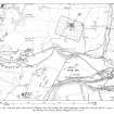
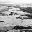
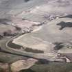
(NT 1878 4056) Roman Fort (R)
OS 6" map (1963)
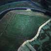
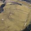
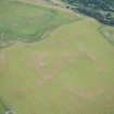
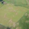
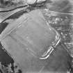
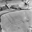
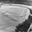
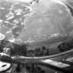
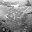
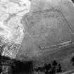
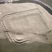
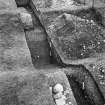
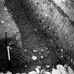
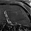
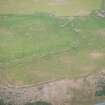
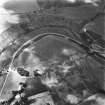
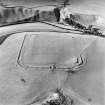
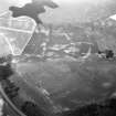
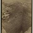
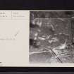
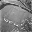
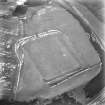
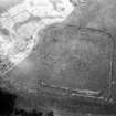
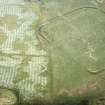
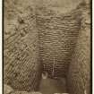
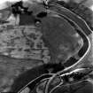
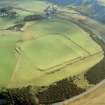
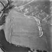
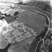
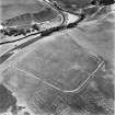
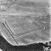
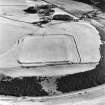
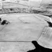
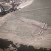
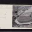
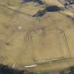
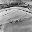
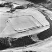
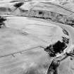
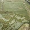
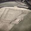
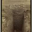
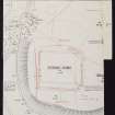
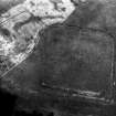
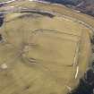
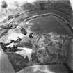
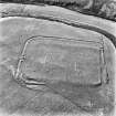
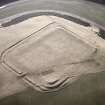
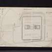
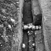
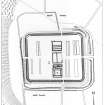
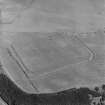
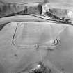
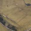
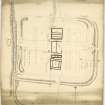
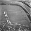
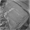
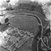
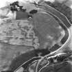
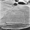
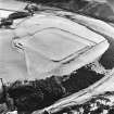
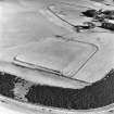
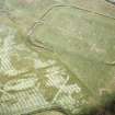
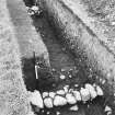
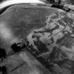
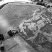
Excavations in 1900, and later years have shown that this fort measures 544' E-W by 450' N-S within a rampart ranging from 20' to 32' in thickness at base, which is still traceable for the most part on the ground, particularly along the W side, where it is 8' high, and also at the NE corner. It was built of turf and earth, and supported on each side by a narrow kerb of natural boulders. The ditches vary from one to three (see plan), measuring from 9' - 18' wide, and 4-5' deep, but the medial and outer ditches, and possibly the inner one had mounds built along their margins. Except at the NE corner, these mounds have been levelled by cultivation, and also those beside the outer ditch are still visible along the E and S fronts.
The buildings were built of red sandstone, with the principia in the centre, and to its S, a granary and the commandant's house, ranged round a courtyard. N of the principia was a large square building, presumably a store or workshop. The rest of the buildings were wooden, but except in the NE quarter, where two barracks and a possible stable were identified, they are not well known. There were annexes attached to the N and S sides. Originally they only enclosed ground lying to the W of the N and S gates, but the N annexe was later enlarged, and a ditch running S from the SE corner may represent a similar enlargement of the S annexe. No inscriptions have been found, but it is thought that the size of the fort is appropriate to a cohors millaria equitata, the presence of a mounted contingent being implied by the wide streets, and a horseshoe found in 1901.
The fort was built in the late Antonine period, and probably occupied for only a few years.
The finds made during the 1959-63 excavations were presented to the National Museum of Antiquities of Scotland (NMAS).
RCAHMS 1967, visited 1963; Proc Soc Antiq Scot 1968
When field investigated in 1961, the condition of this fort was found to be as described above.
Visited by OS (EGC) 31 July 1961
Generally as described by RCAHMS.
Resurveyed at 1:2500 from APs and RCAHMS plan.
Visited by OS (RD) 22 July 1971
Photographed by the RCAHMS in 1976 and 1980.
Sbc Note
Visibility: This is an upstanding earthwork or monument.
Information from Scottish Borders Council

