
Following the launch of trove.scot in February 2025 we are now planning the retiral of some of our webservices. Canmore will be switched off on 24th June 2025. Information about the closure can be found on the HES website: Retiral of HES web services | Historic Environment Scotland
Loss Burn


Country House (18th Century) - (19th Century), Farmstead (18th Century) - (19th Century), Kiln Barn (Post Medieval)
Site Name Loss Burn
Classification Country House (18th Century) - (19th Century), Farmstead (18th Century) - (19th Century), Kiln Barn (Post Medieval)
Alternative Name(s) Loss
Canmore ID 47146
Site Number NS89NW 40.01
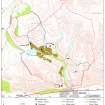
NGR NS 8367 9900
Datum OSGB36 - NGR
Permalink http://canmore.org.uk/site/47146


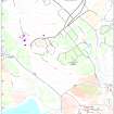


- Council Stirling
- Parish Logie (Stirling)
- Former Region Central
- Former District Stirling
- Former County Stirlingshire
Note (27 August 1996)
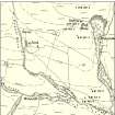
A farmstead, which comprises a roofed courtyard steading is depicted on the 1st edition of the OS 6-inch map (Stirlingshire sheet x, 1865). Two roofless buildings, on the E and S sides of the yard are shown on the current edition of the OS 1:100000 map (1978).
Information from RCAHMS (PM) 27 August 1996
Field Visit (21 May 1997)
NS89NW 40.01 8367 9900
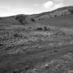
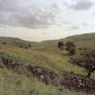
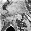
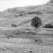
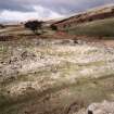
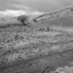
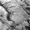
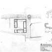
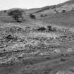
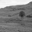
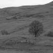
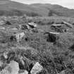
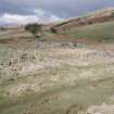
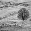
The mortared-rubble footings of a farmstead, comprising a dwelling, byre and barn ranged around a square yard and garden enclosures to the S and E, are situated on a ridge between the Crunie Burn and the Loss Burn. The farmstead originates as a summer residence, built in the mid-18th century by J. Wright. An undated early 19th century plan (SRO RHP 20943) depicts two buildings, lying at right-angles to each other. The location of the western building corresponds to the dwelling house of the farmstead and there is every reason to believe that it is the same structure. The second building has been demolished and may have lain on the W side of the garden enclosure to the E of the farmstead. The dwelling, referred to by Wright as 'the mansion house' is built of mortared rubble, measuring 12m by 4.6m internally with no remaining indications of subdivisions, although the provision of a fireplace in both end walls and the middle of the N side, suggests at least three compartments. The S side of the building has been largely robbed, removing the doorway and windows. The fireplace in the E end has a curved side and fine mouldings, and is probably of mid-18th century date. At the W end of the building there is an outshot, measuring 4.4m square and entered from the S. The ONB (1865-6) records that it was a single storey structure and does no mention an attic. It is clear from documentation of rebuilding work during the mid-18th century that there was a second floor (information from John Harrison), but this may have been removed by the mid-19th century.
The depiction of the farmstead on the 1st edition of the OS 6-inch map (Perthshire and Clackmanannshire 1865-6, sheet cxxxiii; Parts of Stirlingshire 1865-6, sheets x and xi) shows the courtyard steading and the Name Book records that the one storey farmsteading is unoccupied and partly in ruins. All the buildings have a similar character, with dressed sandstone door jambs throughout and they have bonded junctions with the enclosure wall. This might indicate a single phase of construction but the documentation for the mid-18th century building work refers to digging out the founds and part of the building may have been largely demolished and bonded into the additional structures.
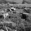
A two-compartment building lies along the E side of the courtyard. The S compartment has two entrances, one on the S, the other opening into the yard on the W. A ragged wall line subdivides the interior from E to W, and may post-date the dereliction of the building as it appears to ride up over debris from the walls. The N compartment has opposed entrances and may have been a barn. The junction between the barn and the dwelling is bonded, although there are differences in the stonework which suggest that the corner of the dwelling was taken down when the barn was built.
Along the N side of the yard there is a low stony platform, corresponding with a roofed structure shown on the 1st edition of the OS 6-inch map, perhaps an open fronted shed. The yard is slightly dished, with a low platform along the N side of the dwelling but there is none of the scouring or vegetational differences to suggest that it has been a midden.
A two compartment building lies along the W side of the yard. A byre drain runs diagonally across the interior of the S compartment, into which there are two opposed entrances, the eastern of which, leading into the yard, has been blocked. There is access from the NW corner of the byre to the N compartment, which also has an entrance in the E side. A pen in the NE corner and several other, possibly structural, dumps of stone obscure the interior of the compartment.
A kiln-barn to NE of farmsteading may be a relict of a settlement predating the mid-18th century Mansion House. The bowl measures 2.1m in diameter, with a barn to the S.
(MENS97 102-4, 107, 108)
Visited by RCAHMS (DCC) 21 May 1997

