
Following the launch of trove.scot in February 2025 we are now planning the retiral of some of our webservices. Canmore will be switched off on 24th June 2025. Information about the closure can be found on the HES website: Retiral of HES web services | Historic Environment Scotland
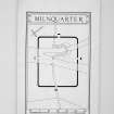
Milnquarter


Temporary Camp (Roman)
Site Name Milnquarter
Classification Temporary Camp (Roman)
Alternative Name(s) Antonine Wall, Milnquarter
Canmore ID 46802
Site Number NS87NW 5
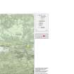
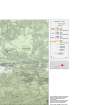
NGR NS 8257 7935
Datum OSGB36 - NGR
Permalink http://canmore.org.uk/site/46802


- Council Falkirk
- Parish Falkirk
- Former Region Central
- Former District Falkirk
- Former County Stirlingshire
NS87NW 5 8257 7935.
(NS 8257 7935) ROMAN CAMP (R) (site of)
OS 6" map (1967)
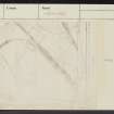
No trace of the Roman temporary camp at Milnquarter can now be seen. It was first noticed on air photographs (CPE/Scot/UK 256: 5331-2 and CUCAP) and with these aids the exact position of the camp was located by probing. It is rectangular, 540' NW-SE by 420', the internal area being about 5.2 acres. The NW, NE and SE gates, with tutuli, were found by probing, but the SW gate lies under a railway embankment.
R W Feachem 1958; RCAHMS 1963, visited 1955.
No further information.
Surveyed at 1:2500.
Visited by OS (WDJ) 30 April 1959 and (MJF) 20 April 1980.
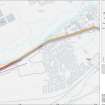
NS 8261 7934. Archaeological monitoring was undertaken on 11 July 1995 of the cutting of the foundations of a dismantled electricity tower which had stood within this camp. Four small trenches c. 0.8m by 0.8m in area were excavated by hand around each leg foundation, and the tower foundations cut. Evidence of a buried ploughsoil was identified in the NW trench at a depth of 0.3m, but elsewhere all excavated material appeared to comprise disturbed backfill associated with the erection and/or maintenance of the tower. No remains associated with the Roman temporary camp were identified. Adherence to a Methods Statement for the removal of the tower, agreed in advance between Historic Scotland and Scottish Power, ensured that no damage occurred to the site.
Full details are lodged with the NMRS.
Sponsor: Scottish Power plc.
A Dunwell and B Finlayson 1995; NMRS MS/726/73.
Aerial Photography (23 July 1953)
Aerial Photography (25 July 1953)
Field Visit (27 January 1955)
NS87NW 825 794 (unnoted)
Roman Temporary Camp, Milnquarter (Site).
This camp is situated on comparatively level ground 270 yds. SE. of Milnquarter farmhouse and a quarter of a mile S. of the Antonine Wall. No trace of the structure can now be seen on the surface, and its presence was only revealed when part of the outline, in the form of a crop-marking, was observed from the air and photographed by Dr. St. Joseph (1). An adjacent corner appeared on a pair of National Survey air-photographs (2), and with these aids the exact position of the camp was located on the ground by means of probing. The camp is rectangular on plan and measures 540 ft. in length from NW. to SE. by 420 ft. transversely, the internal area being about 5.2 acres. The NW., NE. and SE. gates, with tutuli, were found by probing, but the SW. gate lies under a railway embankment. This camp, a similar one at Little Kerse (NS97NW 12), and two others outside Stirlingshire have been described and their purpose discussed elsewhere (3).
RCAHMS 1963, visited 27 January 1955.
(1) Nos. MP 66, 68, 70 and MT 12 in the C.U.C.A.P.
(2) CPE/SCOT/UK 256, 5331-2.
(3) PSAS, lxxxix (1955-6), 329 ff. and fig. 2.
Reference (1957)
This site is noted in the ‘List of monuments discovered during the survey of marginal land (1951-5)’ (RCAHMS 1957, xiv-xviii).
Information from RCAHMS (GFG), 24 October 2012.
Field Visit (30 April 1959)
No further information.
Surveyed at 1:2500.
Visited by OS (WDJ) 30 April 1959
Note (1978)
Milnquarter, Temporary Camp NS 825793 NS87NW 5
Listed as temporary camp.
RCAHMS 1978
(Feachem 1956, 329-32, 335-6; RCAHMS 1963, p. 107; No. 119)
Aerial Photography (31 July 1979)
Field Visit (20 April 1980)
No further information.
Surveyed at 1:2500.
Visited by OS (MJF) 20 April 1980.
Watching Brief (11 July 1995)
NS 8261 7934. Archaeological monitoring was undertaken on 11 July 1995 of the cutting of the foundations of a dismantled electricity tower which had stood within this camp. Four small trenches c. 0.8m by 0.8m in area were excavated by hand around each leg foundation, and the tower foundations cut. Evidence of a buried ploughsoil was identified in the NW trench at a depth of 0.3m, but elsewhere all excavated material appeared to comprise disturbed backfill associated with the erection and/or maintenance of the tower. No remains associated with the Roman temporary camp were identified. Adherence to a Methods Statement for the removal of the tower, agreed in advance between Historic Scotland and Scottish Power, ensured that no damage occurred to the site.
Full details are lodged with the NMRS.
Sponsor: Scottish Power plc.
A Dunwell and B Finlayson 1995; NMRS MS/726/73.
Publication Account (2008)
A 1:25000 scale map of the Antonine Wall was published by RCAHMS in 2008. The map shows the course of the Antonine Wall on a modern map base, including areas where the Wall is in public ownership or care and can be visited. The data had been collated as part of the project to prepare maps for the World Heritage Site nomination bid.
Publication Account (17 December 2011)
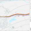
The camp at Milnquarter lies in a flat area of ground bisected by the Stirling-to-Glasgow railway line, and also by a disused connecting line that ran to an industrial complex just to the north. It lies about 400m south of the Antonine Wall, at a point where the Wall kinks between the fort at Rough Castle and the fortlet at Seabegs Wood. A further fortlet has been postulated in this area (Hanson and Maxwell 1986: 122), but no trace has yet been found. The camp was first recorded by St Joseph in 1953, with further information gleaned from RAF air photographs (Feachem 1958: 330; RCAHMS 1963: 107). All four corners and parts of all four sides of the camp have been recorded through cropmarks, and it measures 168m from north-west to south-east by 138m, enclosing an area of almost 2.3ha (5.6 acres). A titulus is visible in the centre of the north-west side, and Feachem recorded other tituli on the north-east and south-east sides through probing (Feachem 1958: 331–2) thus suggesting that the camp faced north-west towards the Wall.
A small excavation was undertaken in the interior of the camp in 1995 owing to the removal of an electricity tower, but no Roman features were recorded (Dunwell and Finlayson 1995).
R H Jones.
Aerial Photographic Transcription (27 June 2022)
An interpretative transcription, or mapping, of information on oblique aerial photographs was produced on 27 June 2022.
Information from HES Archaeological Survey (K. Millican) 29 June 2022.

