|
Photographs and Off-line Digital Images |
B 51670 PO |
Cambridge University Collection for Aerial Photography |
Aerial view |
31/7/1979 |
Item Level |
|
|
Photographs and Off-line Digital Images |
B 51671 PO |
Cambridge University Collection for Aerial Photography |
Aerial view |
31/7/1979 |
Item Level |
|
|
Photographs and Off-line Digital Images |
B 51672 PO |
Cambridge University Collection for Aerial Photography |
Aerial view |
31/7/1979 |
Item Level |
|
|
Photographs and Off-line Digital Images |
B 98499 NC |
General Collection: Newscuttings |
Newscutting from 'The Scotsman' 24 October 1994 regarding damage to site. |
24/10/1994 |
Item Level |
|
|
Photographs and Off-line Digital Images |
ST 2613 PO |
Cambridge University Collection for Aerial Photography |
Aerial view |
23/7/1953 |
Item Level |
|
|
Photographs and Off-line Digital Images |
ST 2614 PO |
Cambridge University Collection for Aerial Photography |
Aerial view |
23/7/1953 |
Item Level |
|
|
Photographs and Off-line Digital Images |
ST 2615 PO |
Cambridge University Collection for Aerial Photography |
Aerial view |
25/7/1953 |
Item Level |
|
|
Photographs and Off-line Digital Images |
ST 2616 PO |
Cambridge University Collection for Aerial Photography |
Aerial view |
23/7/1953 |
Item Level |
|
|
Prints and Drawings |
STD 177/1 |
|
Publication drawing; map of Milnquarter Roman temporary camp superimposed upon the OS map (sheet nxxxix.8) (Feachem 1958 fig. 2) |
1958 |
Item Level |
|
|
Prints and Drawings |
STD 177/2 |
|
Plan, ink, 1":100' |
1958 |
Item Level |
|
|
Manuscripts |
MS 726/73 |
Records of CFA Archaeology Ltd, archaeologists, Musselburgh, East Lothian, Scotland |
Bonnybridge-Cumbernauld/Bathgate Overhead Line Refurbishment: report on the archaeological monitoring of the dismantling of three transmission towers, at Rough Castle, Elf Hill and Milnquarter: [CFA report no. 229], |
1995 |
Item Level |
|
|
Photographs and Off-line Digital Images |
SC 1918923 |
Cambridge University Collection for Aerial Photography |
Aerial view |
23/7/1953 |
Item Level |
|
|
Photographs and Off-line Digital Images |
SC 1919014 |
Cambridge University Collection for Aerial Photography |
Aerial view |
25/7/1953 |
Item Level |
|
|
Photographs and Off-line Digital Images |
SC 1919015 |
Cambridge University Collection for Aerial Photography |
Aerial view |
23/7/1953 |
Item Level |
|
|
Photographs and Off-line Digital Images |
SC 1919024 |
Cambridge University Collection for Aerial Photography |
Aerial view |
23/7/1953 |
Item Level |
|
|
Photographs and Off-line Digital Images |
SC 1919037 |
Cambridge University Collection for Aerial Photography |
Aerial view |
25/7/1953 |
Item Level |
|
|
Digital Files (Non-image) |
GV 007519 |
Records of Historic Scotland, Edinburgh, Scotland |
Map 3 of 8 from IV.I 1-8 - Series 1: Maps of the Antonine Wall at a scale of 1:25000 showing the proposed World Heritage Site, known forts and fortlets, camps, other features and the buffer zones. Maps were prepared for the nomination document to propose the extension of the Frontiers of the Roman Empire World Heritage Site through the addition of the Antonine Wall. |
2006 |
Item Level |
|
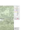 |
On-line Digital Images |
SC 1926553 |
Records of Historic Scotland, Edinburgh, Scotland |
Map 3 of 8 from IV.I 1-8 - Series 1: Maps of the Antonine Wall at a scale of 1:25000 showing the proposed World Heritage Site, known forts and fortlets, camps, other features and the buffer zones. Maps were prepared for the nomination document to propose the extension of the Frontiers of the Roman Empire World Heritage Site through the addition of the Antonine Wall. |
2006 |
Item Level |
|
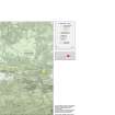 |
On-line Digital Images |
SC 1927846 |
Records of Historic Scotland, Edinburgh, Scotland |
Map 3 of 8 from IV.2 1-8 - Series 2: Maps of the Antonine Wall at a scale of 1:25000 showing the proposed World Heritage Site, known forts and fortlets, camps, other features and the buffer zones. Maps were prepared for the nomination document to propose the extension of the Frontiers of the Roman Empire World Heritage Site through the addition of the Antonine Wall. |
2006 |
Item Level |
|
|
Digital Files (Non-image) |
GV 007526 |
Records of Historic Scotland, Edinburgh, Scotland |
Map 3 of 8 from IV.2 1-8 - Series 2: Maps of the Antonine Wall at a scale of 1:25000 showing the proposed World Heritage Site, known forts and fortlets, camps, other features and the buffer zones. Maps were prepared for the nomination document to propose the extension of the Frontiers of the Roman Empire World Heritage Site through the addition of the Antonine Wall. |
2006 |
Item Level |
|
|
Digital Files (Non-image) |
GV 007548 |
Records of Historic Scotland, Edinburgh, Scotland |
Map 15 of 39 from Series V. Maps of the Antonine Wall and its known features at a scale of 1:5000 showing the scheduled areas and the proposed World Heritage Site. Maps were prepared for the nomination document to propose the extension of the Frontiers of the Roman Empire World Heritage Site through the addition of the Antonine Wall. |
2006 |
Item Level |
|
|
Digital Files (Non-image) |
GV 007547 |
Records of Historic Scotland, Edinburgh, Scotland |
Map 14 of 39 from Series V. Maps of the Antonine Wall and its known features at a scale of 1:5000 showing the scheduled areas and the proposed World Heritage Site. Maps were prepared for the nomination document to propose the extension of the Frontiers of the Roman Empire World Heritage Site through the addition of the Antonine Wall. |
2006 |
Item Level |
|
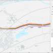 |
On-line Digital Images |
SC 1929336 |
Records of Historic Scotland, Edinburgh, Scotland |
Map 14 of 39 from Series V. Maps of the Antonine Wall and its known features at a scale of 1:5000 showing the scheduled areas and the proposed World Heritage Site. Maps were prepared for the nomination document to propose the extension of the Frontiers of the Roman Empire World Heritage Site through the addition of the Antonine Wall. |
2006 |
Item Level |
|
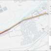 |
On-line Digital Images |
SC 1929337 |
Records of Historic Scotland, Edinburgh, Scotland |
Map 15 of 39 from Series V. Maps of the Antonine Wall and its known features at a scale of 1:5000 showing the scheduled areas and the proposed World Heritage Site. Maps were prepared for the nomination document to propose the extension of the Frontiers of the Roman Empire World Heritage Site through the addition of the Antonine Wall. |
2006 |
Item Level |
|


