Accessibility

Font Size

100% 150% 200%

Background Colour

Default Contrast
Close Reset

Buchley

Enclosure (Roman)

Site Name Buchley

Classification Enclosure (Roman)

Alternative Name(s) Antonine Wall

Canmore ID 44486

Site Number NS57SE 21
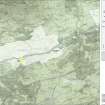
NGR NS 59251 71990

Datum OSGB36 - NGR

Permalink http://canmore.org.uk/site/44486

Ordnance Survey licence number AC0000807262. All rights reserved.
Canmore Disclaimer. © Bluesky International Limited 2025. Public Sector Viewing Terms

Toggle Aerial | View on large map

Digital Images

Oblique aerial view of Buchley enclosure.
Oblique aerial view of Buchley enclosure.Aerial view of the Antonine Wall (c. 594 720) and the locations of a Roman fortlet and two Roman enclosures, taken from the NE.Oblique aerial view.Map 30 of 39 from Series V. Maps of the Antonine Wall and its known features at a scale of 1:5000 showing the scheduled areas and the proposed World Heritage Site. Maps were prepared for the nomination document to propose the extension of the Frontiers of the Roman Empire World Heritage Site through the addition of the Antonine Wall.Buchley, NS57SE 21, Ordnance Survey index card, RectoGeneral view, Buchley, Cadder, Lanarkshire, Scotland, 1937. Oblique aerial image, taken facing north-east.Oblique aerial view.Oblique aerial view.Map showing the Antonine Wall, the World Heritage Site area, the areas of the World Heritage Site in public ownership or care, the Buffer Zone and the Council boundaries. Created for the World Heritage Site nomination - Management plan.Buchley, NS57SE 21, Ordnance Survey index card, RectoMap 6 of 8 from IV.I 1-8 - Series 1: Maps of the Antonine Wall at a scale of 1:25000 showing the proposed World Heritage Site, known forts and fortlets, camps, other features and the buffer zones. Maps were prepared for the nomination document to propose the extension of the Frontiers of the Roman Empire World Heritage Site through the addition of the Antonine Wall.Map 6 of 8 from IV.2 1-8 - Series 2: Maps of the Antonine Wall at a scale of 1:25000 showing the proposed World Heritage Site, known forts and fortlets, camps, other features and the buffer zones. Maps were prepared for the nomination document to propose the extension of the Frontiers of the Roman Empire World Heritage Site through the addition of the Antonine Wall.General aerial view of the Antonine Wall (c. 594 720) and the locations of a Roman fortlet and two Roman enclosures, taken from the ENE.Oblique aerial view.Map 7 of 8 from IV.I 1-8 - Series 1: Maps of the Antonine Wall at a scale of 1:25000 showing the proposed World Heritage Site, known forts and fortlets, camps, other features and the buffer zones. Maps were prepared for the nomination document to propose the extension of the Frontiers of the Roman Empire World Heritage Site through the addition of the Antonine Wall.Antonine Wall 1:25000 broadsheet map Oblique aerial view.Map 7 of 8 from IV.2 1-8 - Series 2: Maps of the Antonine Wall at a scale of 1:25000 showing the proposed World Heritage Site, known forts and fortlets, camps, other features and the buffer zones. Maps were prepared for the nomination document to propose the extension of the Frontiers of the Roman Empire World Heritage Site through the addition of the Antonine Wall.Buchley, NS57SE 21, Ordnance Survey index card, page number 1, Recto

Administrative Areas

  • Council East Dunbartonshire
  • Parish Cadder (Strathkelvin-du)
  • Former Region Strathclyde
  • Former District Strathkelvin
  • Former County Lanarkshire

Archaeology Notes

NS57SE 21 59251 71990

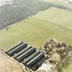
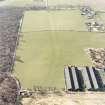
(NS 59251 71990) The crop mark of a sub rectangular, ditched, enclosure, abutting the south side of the Antonine Wall, is visible on RCAHMS air photographs. It is one of a similar group of 3 identified in the same sector of the Wall; (see also NS57SE 19 and NS67SW 29) that at NS 59507206 was excavated in 1980 (see NS57SE 19). Their purpose is at present uncertain.

Visible on RCAHMS air photographs LA 2031-4, flown 1977.

(Undated) information in NMRS.

There is no surface trace of the enclosure or of the Antonine Wall in a level, arable field.

Visited by OS (J R L) 29 April 1981.

Activities

Aerial Photography (1979)

Field Visit (29 April 1981)

There is no surface trace of the enclosure or of the Antonine Wall in a level, arable field.

Visited by OS (J R L) 29 April 1981.

Note (1982)

Wilderness Plantation, Enclosures NS 592 719, 595 720, 600 721 NS57SW NS67SW

In the sector of the Antonine Wall N of Wilderness Plantation three sub-rectangular enclosures abutting the S face of the Rampart have been identified from cropmarks. The eastermost, situated 260m E of the Wilderness Plantation fortlet (NS57SE 11), has been destroyed; the other two lie 285m and 580m respectively W of the fortlet. They appear to have been almost identical in size, and excavation of the central one shows that it measured about 6m square within a bank with external ditch, and belonged to the primary phase of the Wall. Its purpose is uncertain, but it is unlikely to have been a turret or beacon-stance.

RCAHMS 1982

(RCAHMS 1978, pp. 113, 159, No. 247; DES, 1980, 82.)

Aerial Photography (4 March 1997)

Publication Account (2008)

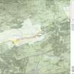
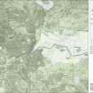
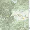
A 1:25000 scale map of the Antonine Wall was published by RCAHMS in 2008. The map shows the course of the Antonine Wall on a modern map base, including areas where the Wall is in public ownership or care and can be visited. The data had been collated as part of the project to prepare maps for the World Heritage Site nomination bid.

References

MyCanmore Image Contributions


Contribute an Image

MyCanmore Text Contributions