
Wilderness Plantation


Fortlet (Roman)
Site Name Wilderness Plantation
Classification Fortlet (Roman)
Alternative Name(s) Antonine Wall, Wilderness Plantation
Canmore ID 44475
Site Number NS57SE 11
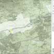
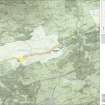
NGR NS 59803 72120
Datum OSGB36 - NGR
Permalink http://canmore.org.uk/site/44475


- Council East Dunbartonshire
- Parish Cadder (Strathkelvin-du)
- Former Region Strathclyde
- Former District Strathkelvin
- Former County Lanarkshire
NS57SE 11 59803 72120
(NS 59803 72120) Roman Fortlet (R) (site of)
OS 6" map, (1971)
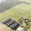
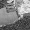
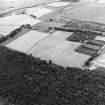
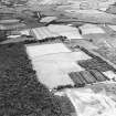
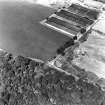
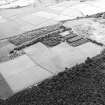
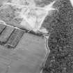
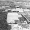
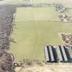
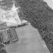
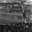
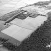
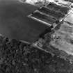
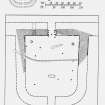
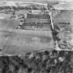
This Roman Fortlet, first revealed by crop-markings on air photographs (visible on CUCAP air photographs U 53-6, V81), occupies a commanding position, attached to the S side of the Antonine Wall, on the northern crest of a low ridge overlooking the valley of the River Kelvin immediately N of Wilderness Plantation. Excavation of the site by Wilkes (1974) in 1965-6 showed that the fortlet was of one build with the Wall and thus represented an original element in its construction. Although ploughing in recent times had removed most of the S half of the fortlet, it was possible to estimate that it had originally measured about 19.8 m by 17.5 m internally. The N defence was formed by the Wall and its Ditch, of which only the former could be even partially examined during the excavation, while on the remaining three sides the fortlet was defended by a turf rampart laid on a stone foundation 3.0 m thick and by double ditches. The inner ditch, separated from the outer face of the rampart by a berm 4.3 m broad, measured 3.7 m wide by 2.1 m deep; the outer lay 2.7 m beyond the inner and measured 4.0 m by 2.4 m. Both were interrupted for a short distance opposite the presumed position of the S gate. The N gate, however, which consisted of a single passageway 2.0 m wide, with sides revetted by a timber framework, does not appear, on the evidence of the air photographs, to have been provided with a causeway across the Antonine Ditch.
The interior contained a number of post-holes belonging to the first phase of occupation (A-J on plan), as well as a stone-line culvert (K), two hearths (L, M), an irregularly-shaped turf-packed pit (N), and a short length of a shallow channel (P), possibly a drain. Post-holes A, B, C and D probably belonged to a rectangular timber barrack about 4.3 m wide and at least 6.1 m long, and the W side of a complementary building may be indicated by H and J. Although the purpose of the remaining post-holes (E, F and G) is uncertain, the excavator suggested that they marked the positions of lean-to structures erected over the two hearths. At some later date, however, the timber buildings were removed and the interior of the fortlet was covered with cobbling. Considerable quantities of coarse pottery were found, both above and below the cobbled layer, especially around the two hearths, which appeared to have remained in use during the second phase of occupation; all the sherds were datable to the Antonine period. Sherds of medieval pottery, of 15th or 16th century date, and a few fragments of post-medieval ware were also found.
J J Wilkes 1974; RCAHMS 1978.
There are no visible remains of this fortlet. The site is under crop.
Visited by OS (B S) 23 April 1975.
Various pottery finds from the fortlet. Present locations unknown.
DES 1976.
There are no surviving surface indications of this fortlet. The area is under crop.
Visited by OS (M J F) 21 June 1980.
Listed. No additional information.
Photo. Plan.
Aerial Photography (October 1965)
Excavation (September 1965 - 1966)
Excavation of the site by Wilkes (1974) in 1965-6 showed that the fortlet was of one build with the Wall and thus represented an original element in its construction. Although ploughing in recent times had removed most of the S half of the fortlet, it was possible to estimate that it had originally measured about 19.8 m by 17.5 m internally. The N defence was formed by the Wall and its Ditch, of which only the former could be even partially examined during the excavation, while on the remaining three sides the fortlet was defended by a turf rampart laid on a stone foundation 3.0 m thick and by double ditches. The inner ditch, separated from the outer face of the rampart by a berm 4.3 m broad, measured 3.7 m wide by 2.1 m deep; the outer lay 2.7 m beyond the inner and measured 4.0 m by 2.4 m. Both were interrupted for a short distance opposite the presumed position of the S gate. The N gate, however, which consisted of a single passageway 2.0 m wide, with sides revetted by a timber framework, does not appear, on the evidence of the air photographs, to have been provided with a causeway across the Antonine Ditch.
The interior contained a number of post-holes belonging to the first phase of occupation (A-J on plan), as well as a stone-line culvert (K), two hearths (L, M), an irregularly-shaped turf-packed pit (N), and a short length of a shallow channel (P), possibly a drain. Post-holes A, B, C and D probably belonged to a rectangular timber barrack about 4.3 m wide and at least 6.1 m long, and the W side of a complementary building may be indicated by H and J. Although the purpose of the remaining post-holes (E, F and G) is uncertain, the excavator suggested that they marked the positions of lean-to structures erected over the two hearths. At some later date, however, the timber buildings were removed and the interior of the fortlet was covered with cobbling. Considerable quantities of coarse pottery were found, both above and below the cobbled layer, especially around the two hearths, which appeared to have remained in use during the second phase of occupation; all the sherds were datable to the Antonine period. Sherds of medieval pottery, of 15th or 16th century date, and a few fragments of post-medieval ware were also found.
J J Wilkes 1974; RCAHMS 1978.
Field Visit (23 April 1975)
There are no visible remains of this fortlet. The site is under crop.
Visited by OS (B S) 23 April 1975.
Artefact Recovery (1976)
Various pottery finds from the fortlet. Present locations unknown.
DES 1976.
Field Visit (21 June 1980)
There are no surviving surface indications of this fortlet. The area is under crop.
Visited by OS (M J F) 21 June 1980.
Aerial Photography (1981)
This Roman Fortlet, first revealed by crop-markings on air photographs (visible on CUCAP air photographs U 53-6, V81), occupies a commanding position, attached to the S side of the Antonine Wall, on the northern crest of a low ridge overlooking the valley of the River Kelvin immediately N of Wilderness Plantation.
Note (1982)
Wilderness Plantation, Fortlet NS 598 721 NS57SE 11
This fortlet, which was first identified from cropmarks, abuts the S face of the Antonine Wall about half-way between the forts of Balmuildy (NS57SE) and Cadder (NS67SW 16). Excavations in 1965-6 revealed that it had measured 19.8m by 17 .5m within the rampart, which appeared to be of one build with the Wall. The interior was eventually cobbled throughout, but in an earlier phase it had contained hearths and timber structures, presumably barracks for the garrison.
RCAHMS 1982
(Wilkes 1974; RCAHMS 1978, pp. 136-7, No. 261)
Excavation (November 2004)
Report - Archaeological evaluation at Buchley Lodge, Bishopbriggs, 2004.
Publication Account (2008)
A 1:25000 scale map of the Antonine Wall was published by RCAHMS in 2008. The map shows the course of the Antonine Wall on a modern map base, including areas where the Wall is in public ownership or care and can be visited. The data had been collated as part of the project to prepare maps for the World Heritage Site nomination bid.
Aerial Photography
Aerial Photography
This Roman Fortlet, first revealed by crop-markings on air photographs, occupies a commanding position, attached to the S side of the Antonine Wall, on the northern crest of a low ridge overlooking the valley of the River Kelvin immediately N of Wilderness Plantation.

