
Bute, Clachan Ard


Cup Marked Rock (Neolithic) - (Bronze Age), Dun (Period Unassigned)
Site Name Bute, Clachan Ard
Classification Cup Marked Rock (Neolithic) - (Bronze Age), Dun (Period Unassigned)
Alternative Name(s) Clach Carnie
Canmore ID 40269
Site Number NS05NW 3
NGR NS 04460 58117
Datum OSGB36 - NGR
Permalink http://canmore.org.uk/site/40269


- Council Argyll And Bute
- Parish North Bute
- Former Region Strathclyde
- Former District Argyll And Bute
- Former County Buteshire
Desk Based Assessment (21 July 1972)
NS05NW 3 04460 58123.
(NS 0445 5812) Clach Carnie (NR)
OS 6" map, (1957)
Clachcarnie, or Clachan Ard fort (Hewison 1893) is bounded on the NW by a 55-60ft high cliff, and on the other sides by a curving wall, enclosing an area 96ft x 62ft. The wall is much dilapidated, only a few facing-stones being visible, though excavations by Lord Bute in 1933 showed it to be 10ft thick. The entrance is in the E. A saddle quern was found, also part of a kitchen midden of bones and shells, during the excavation, where shown on plan.
Information from OS (IF) 21 July 1972
J N Marshall 1934; 1935; J K Hewison 1893.
Field Visit (15 July 1975)
A small fort defenced by a single stone wall some 10ft in thickness, and having a wide entrance. It was partly excavated by the grandfather of the present Lord Bute, and a plan was made by Dorothy Marshall. The wall was partially rebuilt on that occasion. The site is probably represented by the short length of hachure W of the figure 7 on the OS map.
Information from K A Steer, 15 July 1975
Field Visit (15 November 1976)
Clachan Ard (name verified): a large dun built on the edge of a coastal cliff. The semi-circular stone wall and cliff edge enclose a sub-oval level area 31.5m long (NE-SW) by 17.5m wide. There has apparently been some reconstruction because the wall is in a very good condition and not as described by Hewison. It is 2.7m wide, 0.7m high internally and 1.2m high externally with a clearly defined 2.1m wide entrance to the east. The flat stone at NS 0446 5812 has three shallow cup markings. The quern stone, kitchen midden and "hollowed rock" were not located.
Surveyed at 1:2500.
Visited by OS (T R G) 15 November 1976.
Field Visit (5 May 2009)
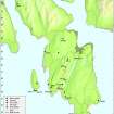
This dun is situated at the top of a NW-facing cliff 550m W of Ardscalpsie farmsteading (NS05NE 111). Roughly oval on plan, it measures about 24m from NE to SW by 18m transversely within steep natural slopes and cliffs on the W and N and a wall elsewhere that measures 2.6m in thickness and about 1m in height. This wall was partly reconstructed in 1933 as part of a series of works, which included excavation, instigated by the 4th Marquess of Bute. The level above which the wall has been reconstructed is marked by a series of small lead plates, inserted into the wall-face. There is an entrance on the E and the cup marked stone in the interior of the dun is as previously described.
Visited by RCAHMS (AGCH) 5 May 2009.
Measured Survey (2009 - 2010)
A series of measured drawings undertaken as part of ACFA's CARES project.
Field Visit (2009 - 2010)
This promontory fort was partly excavated in 1933 at the instigation of the Marquis of Bute and described and planned in reports by Dr John Marshall (Marshall J N 1934,1935b) A saddle quern and an area of kitchen midden of bones and shells were the only finds. A later visit by the OS Archaeology Division in 1976 is noted in Canmore:
‘ …a large dun built on the edge of a coastal cliff. The semi-circular stone wall and cliff edge enclose a sub-oval level area 31.5m long (E-W) by 17.5m wide…the wall…is 2.7m wide, 0.7m high internally and 1.2m high externally with a clearly-defined 2.1m wide entrance to the east.’
At the time of our visit the general outline of the fort was much as described above, though the enclosing wall appeared slightly wider, varying from 3.6m wide S of the entrance to 2.9m wide as it contracts on the western escarpment.
A cup-marked stone in the interior, mentioned in the 1934 excavation report, was identified; the cup-marks are now very faint and obscured by turf.Near the W (seaward) side, another boulder, lying in a slight hollow, may be the ‘flat stone covering a hollowed out rock’ indicated on Marshall’s site plan. There is no sign of the area of kitchen midden identified in 1933.
The main change in the site is in the condition of the fort wall. Apparently ruinous when described by Hewison in The Isle of Bute in the olden time,Volume 1 (1893), it was also said to be ‘in a tumble-down condition’ in Marshall’s 1934 report, with ‘only here and there…something which could be recognised as a wall-face’.
By contrast the 1976 OS description states:
‘There has apparently been some reconstruction because the wall is in a very good condition…’ and certainly it now appears well-built and complete on the outer face, though much obscured by vegetation.
It is not clear whether the fort was partly rebuilt after the 1933 excavation, but it is known that a local stonemason, Dan Boag, carried out extensive reconstruction in 1961. Three lead markers are visible on the external wall at around 0.2m above the present ground surface, indicating the level at which reconstruction began. One marker to the S of the entrance is inscribed:
Dan Boag
Tommy
7/th May
1961
How much the appearance of the wall has been changed is open to question. Marshall’s 1934 report states that ‘A very large single stone 8 feet 8 inches long and 2 feet broad formed the greater part of the northern side of the entrance’, but no such stone is visible in the reconstructed wall.
Within and to the W of the entrance is a hollow which may be the remains of one of the 1933 excavation trenches, the section within the entrance passage having been backfilled. There is no sign of the second trench ‘run from the precipice eastward’.
Note (13 July 2020)
Date Fieldwork Started: 13/07/2020
Compiled by: Rock Art Bute
Location Notes: The panel lies in rough grazing in the centre of the roughly oval shaped hillfort/dun of Clachan Ard, directly W of the entrance into the fort. This is a prominent headland site with steep cliffs on the W, seaward, side descending about 20m to the shore and overlooking what would have been an ideally situated landing place (Port na h-Aille). There are open views across the West Kyle of Bute to the island of Inchmarnock as well as Arran and Kintyre.
Panel Notes: This is a small, roughly rectangular fine grained schist type slab measuring 1.2m long by 0.6m wide and flush with the ground. The surface is flat and has a fissure running part way along its N-S long axis. There are 3 definite cupmarks with a maximum diameter of 10cm and a depth of 1.5 cm, and a further possible cupmark. There are visible tool marks. Only just over half the surface area is exposed, the rest of the panel, including 2 of the cupmarks, is covered by turf, which was pulled back for the purpose of examination and then carefully repositioned.

