
RCAHMS Isle of Bute Survey


Date November 2008 - 2011
Event ID 580037
Category Project
Type Project
Permalink http://canmore.org.uk/event/580037
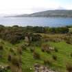
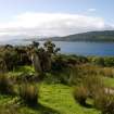
RCAHMS is undertaking a project in partnership with the Discover Bute Landscape Partnership Scheme (DBLPS), which aims to revise the records of all the archaeological sites on the island while providing training opportunities for members of the local community. In 2009, about 650 archaeological sites, including over 100 new sites, were visited. Of particular interest are the extensive pre- and early improvement period cultivation remains, much of which are depicted on a series of detailed estate plans held by the Mount Stuart Trust. Three aerial sorties were also undertaken to record known monuments, cropmarks and improvement period farmsteads. (Discovery and Excavation in Scotland 2009)
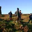
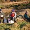
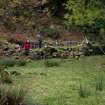
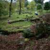
2010 saw the conclusion of the two-year partnership project between RCAHMS and the Discover Bute Landscape Partnership Scheme (DBLPS), first noted last year. This year, the Commission continued in close collaboration with the local community and over 70 volunteers attended a series of training sessions held to teach aspects of archaeological recording. Tuition combined with prospective survey resulted in over 100 previously unrecorded sites being added to the RCAHMS database. The volunteers also undertook detailed survey of individual monuments and participated in training workshops. The former included a preshistoric hut-circle and an Improvement period farmsteading; the latter included topics such as training in archaeological survey techniques, archaeological 'ownership', and the impact of the public contribution to archaeological projects has on the wider geo-political landscape of Scotland.
The culmination of the project was the publication in November of The Archaeological Landscape of Bute, a booklet which describes and discusses the archaeology of Bute from the Mesolithic to the 19th century. The booklet, one of several tangible legacies between RCAHMS, DBLPS and the local population, is a full-colour publication and is illustrated with ground and aerial photography, historical documents, maps and survey drawings. The text highlights particular sites, discusses possible avenues of research, acknowledges the character of previous archaeological investigations on the island, and demonstrates the importance of local driving forces for future work. (Discovery and Excavation in Scotland 2010, 193-4)

| Event | Type | Subtype | Notes | Date |
|---|---|---|---|---|
| 581985 | RECORDING | DESK BASED ASSESSMENT | 1991 | |
| 590491 | RECORDING | FIELD VISIT | This building was not found on the date of visit. The reported location falls within and an area of rig-and-furrow, clearance cairns and rock outcrops. [...] | 6 May 2006 |
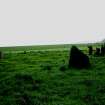
| 590256 | DESCRIPTIVE ACCOUNTS | NOTE | This barrow, which is situated on a broad terrace to the W of Largizean, has been recorded as cropmarks on oblique aerial photography (RCAHMSAP 2008). It is circular on plan, measuring about 6m in diameter within a ring ditch about 2m across. A field boundary, extending from NW to SE, lies a short distance to the W. [...] | 24 December 2008 |

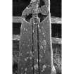
SC 408104
St Colmac Cross, Bute. Early Christian cross-slab.
Records of the Royal Commission on the Ancient and Historical Monuments of Scotland (RCAHMS), Edinbu
© Crown Copyright: HES

DP 064205
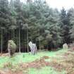
Glenvoidean chambered cairn. View from NW.
Records of the Royal Commission on the Ancient and Historical Monuments of Scotland (RCAHMS), Edinbu
19/5/2009
© Crown Copyright: HES

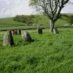
DP 064296
View facing NNE.
Records of the Royal Commission on the Ancient and Historical Monuments of Scotland (RCAHMS), Edinbu
19/5/2009
© Crown Copyright: HES

DP 064297
View facing N.
Records of the Royal Commission on the Ancient and Historical Monuments of Scotland (RCAHMS), Edinbu
19/5/2009
© Crown Copyright: HES

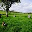
DP 064298
View facing WSW.
Records of the Royal Commission on the Ancient and Historical Monuments of Scotland (RCAHMS), Edinbu
19/5/2009
© Crown Copyright: HES

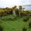
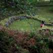
DP 064299
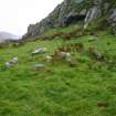
View facing SE of stone circle, St Colmac Cottages, Bute.
Records of the Royal Commission on the Ancient and Historical Monuments of Scotland (RCAHMS), Edinbu
19/5/2009
© Crown Copyright: HES

DP 073220
General view of cave to W of Hawks Nib, taken from S.
Records of the Royal Commission on the Ancient and Historical Monuments of Scotland (RCAHMS), Edinbu
17/3/2009
© Crown Copyright: HES

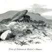
SC 1163929
View of dolmen (Hewison 1893, 65).
Records of the Royal Commission on the Ancient and Historical Monuments of Scotland (RCAHMS), Edinbu
1869
© Crown Copyright: HES

DP 077719
General view taken from the N.
Records of the Royal Commission on the Ancient and Historical Monuments of Scotland (RCAHMS), Edinbu
5/5/2009
© Crown Copyright: HES

SC 1208177
Extract from the 3rd edition of the OS 6-inch map, surveyed in 1915 and published in 1924.
Records of the Royal Commission on the Ancient and Historical Monuments of Scotland (RCAHMS), Edinbu
1924
© Crown Copyright: HES

DP 084694
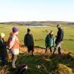
View of RCAHMS staff and members of the public, taken from the SW. From left to right: unknown; Isabell Mcarthur, Angus Hannah, Donald Kinnear, Alex Hale (RCAHMS), unknown.
Records of the Royal Commission on the Ancient and Historical Monuments of Scotland (RCAHMS), Edinbu
8/12/2008
© Crown Copyright: HES

SC 1210134
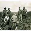
Excavations at Eilean Buidhe dun in August 1936. One of a number of important archive photographs held by Bute Museum, this image shows Dr J N Marshall in the trench flanked by his daughter Dorothy and J Harrison Maxwell, who directed the excavations. The photograph was taken from the SW showing one of the trenches cut through the rampart; the building in the background is the boat house at Caol Ruadh School. © Bute Museum
Records of the Royal Commission on the Ancient and Historical Monuments of Scotland (RCAHMS), Edinbu
8/1936
© Bute Museum

DP 091729
View of burial cairn, taken from the NW.
Records of the Royal Commission on the Ancient and Historical Monuments of Scotland (RCAHMS), Edinbu
13/9/2010
© Crown Copyright: HES

SC 1231864
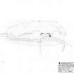
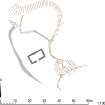
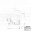
RCAHMS survey drawing; plan of the hut circle at Barr Hill.
Records of the Royal Commission on the Ancient and Historical Monuments of Scotland (RCAHMS), Edinbu
19/3/2010
© Crown Copyright: HES

SC 1231879
RCAHMS survey drawing; plan of the fort and farmstead at Little Dunagoil.
Records of the Royal Commission on the Ancient and Historical Monuments of Scotland (RCAHMS), Edinbu
17/3/2010
© Crown Copyright: HES

SC 1231881
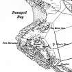
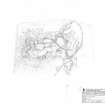
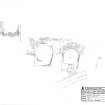
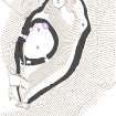
RCAHMS survey drawing; plan of the fort and its environs at Dunagoil.
Records of the Royal Commission on the Ancient and Historical Monuments of Scotland (RCAHMS), Edinbu
17/3/2010
© Crown Copyright: HES

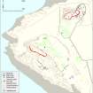
DP 097419
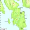
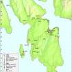
Map - The Isle of Bute, showing Rothesay, other settlements and geographical features.
Records of the Royal Commission on the Ancient and Historical Monuments of Scotland (RCAHMS), Edinbu
8/2010
© Crown Copyright: HES

DP 097420
Map - Distribution of Mesolithic and Neolithic sites and artefacts.
Records of the Royal Commission on the Ancient and Historical Monuments of Scotland (RCAHMS), Edinbu
8/2010
© Crown Copyright: HES

DP 097421
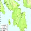
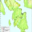
Map - Distribution of Early Bronze Age sites and artefacts.
Records of the Royal Commission on the Ancient and Historical Monuments of Scotland (RCAHMS), Edinbu
8/2010
© Crown Copyright: HES

DP 097422
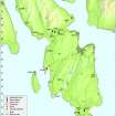
Map - Distribution of sites and artefacts of the Late Bronze Age and Iron Age.
Records of the Royal Commission on the Ancient and Historical Monuments of Scotland (RCAHMS), Edinbu
8/2010
© Crown Copyright: HES

DP 097423
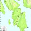
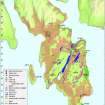
Map - Distribution of Early Historic and Medieval sites and artefacts.
Records of the Royal Commission on the Ancient and Historical Monuments of Scotland (RCAHMS), Edinbu
8/2010
© Crown Copyright: HES

DP 097424
Map- Distribution of Pre-Improvement sites and activity.
Records of the Royal Commission on the Ancient and Historical Monuments of Scotland (RCAHMS), Edinbu
8/2010
© Crown Copyright: HES

DP 097425
Map - Distribution of Improvement period sites and activilty.
Records of the Royal Commission on the Ancient and Historical Monuments of Scotland (RCAHMS), Edinbu
8/2010
© Crown Copyright: HES

SC 1231916
RCAHMS survey drawing; plan and location plan of Kilchousland Chapel.
Records of the Royal Commission on the Ancient and Historical Monuments of Scotland (RCAHMS), Edinbu
15/3/2010
© Crown Copyright: HES

SC 1231918
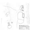
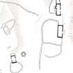
RCAHMS survey drawing; plan of Ardnagave farmstead.
Records of the Royal Commission on the Ancient and Historical Monuments of Scotland (RCAHMS), Edinbu
16/3/2010
© Crown Copyright: HES

SC 1231930
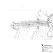
RCAHMS publication drawing; plan and elevation of Ascog salt pans.
Records of the Royal Commission on the Ancient and Historical Monuments of Scotland (RCAHMS), Edinbu
19/3/2010
© Crown Copyright: HES

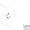
SC 1231932
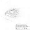
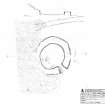
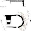
RCAHMS survey drawing; Plan of Dun Scalpsie.
Records of the Royal Commission on the Ancient and Historical Monuments of Scotland (RCAHMS), Edinbu
16/3/2010
© Crown Copyright: HES

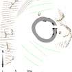
SC 1231934
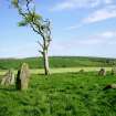
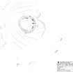
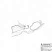
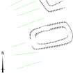
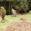
RCAHMS survey drawing; Plan of Colmac Stone Circle.
Records of the Royal Commission on the Ancient and Historical Monuments of Scotland (RCAHMS), Edinbu
15/3/2010
© Crown Copyright: HES

SC 1231936
RCAHMS survey drawing; plan of Stuck farmstead.
Records of the Royal Commission on the Ancient and Historical Monuments of Scotland (RCAHMS), Edinbu
18/3/2010
© Crown Copyright: HES

SC 1231938
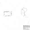
RCAHMS survey drawing; Plans, section and elevation of Kilchattan Lime Kiln.
Records of the Royal Commission on the Ancient and Historical Monuments of Scotland (RCAHMS), Edinbu
30/3/2010
© Crown Copyright: HES

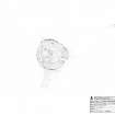
SC 1231940
RCAHMS survey drawing; plan of Bicker's Houses Chambered Cairn.
Records of the Royal Commission on the Ancient and Historical Monuments of Scotland (RCAHMS), Edinbu
30/3/2010
© Crown Copyright: HES

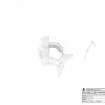
SC 1231949
RCAHMS survey drawing; plan and section of rock shelter at Dunagoil.
Records of the Royal Commission on the Ancient and Historical Monuments of Scotland (RCAHMS), Edinbu
29/3/2010
© Crown Copyright: HES

SC 1231951
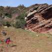
RCAHMS survey drawing; plan of building and enclosures at Butt a Croit, undertaken with local volunteers.
Records of the Royal Commission on the Ancient and Historical Monuments of Scotland (RCAHMS), Edinbu
29/9/2010
© Crown Copyright: HES

SC 1231953
RCAHMS survey drawing; plan of the farmstead at Achavoulaig Butt, undertaken with local volunteers.
Records of the Royal Commission on the Ancient and Historical Monuments of Scotland (RCAHMS), Edinbu
28/9/2010
© Crown Copyright: HES

SC 1231955
RCAHMS survey drawing; Plan of Dun Burgidale, undertaken with local volunteers.
Records of the Royal Commission on the Ancient and Historical Monuments of Scotland (RCAHMS), Edinbu
30/9/2010
© Crown Copyright: HES

SC 1231957
RCAHMS survey drawing; Plan of Ardnahoe fort.
Records of the Royal Commission on the Ancient and Historical Monuments of Scotland (RCAHMS), Edinbu
1/10/2010
© Crown Copyright: HES

SC 1231961
RCAHMS survey drawing; Plan and section of The Cauldron, undertaken with a volunteer.
Records of the Royal Commission on the Ancient and Historical Monuments of Scotland (RCAHMS), Edinbu
15/10/2010
© Crown Copyright: HES

DP 097430
RCAHMS publication illustration; Plan of Barr Hill Hut circle.
Records of the Royal Commission on the Ancient and Historical Monuments of Scotland (RCAHMS), Edinbu
8/2010
© Crown Copyright: HES

DP 097431
RCAHMS publication drawing; Plan of Little Dunagoil Fort.
Records of the Royal Commission on the Ancient and Historical Monuments of Scotland (RCAHMS), Edinbu
8/2010
© Crown Copyright: HES

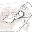
DP 097432
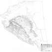
Plan of Dunagoil and Little Dunagoil forts and their environs.
Records of the Royal Commission on the Ancient and Historical Monuments of Scotland (RCAHMS), Edinbu
8/2010
© Crown Copyright: HES

DP 097433
RCAHMS publication illustration; Plan of Kilchousland Chapel
Records of the Royal Commission on the Ancient and Historical Monuments of Scotland (RCAHMS), Edinbu
8/2010
© Crown Copyright: HES

DP 097434
RCAHMS publication illustration; Plan of Ardnagave farmstead.
Records of the Royal Commission on the Ancient and Historical Monuments of Scotland (RCAHMS), Edinbu
8/2010
© Crown Copyright: HES

DP 097435
RCAHMS publication drawing; Plan and section of Ascog salt pans.
Records of the Royal Commission on the Ancient and Historical Monuments of Scotland (RCAHMS), Edinbu
8/2010
© Crown Copyright: HES

DP 097436
RCAHMS publication drawing; Plan of Dun Scalpsie
Records of the Royal Commission on the Ancient and Historical Monuments of Scotland (RCAHMS), Edinbu
8/2010
© Crown Copyright: HES

DP 097437
RCAHMS publication drawing; Plan of St Colmac's Stone Circle.
Records of the Royal Commission on the Ancient and Historical Monuments of Scotland (RCAHMS), Edinbu
8/2010
© Crown Copyright: HES

DP 097438
RCAHMS publication illustration; Plan of buildings and cultivation remains at Craiganlarich.
Records of the Royal Commission on the Ancient and Historical Monuments of Scotland (RCAHMS), Edinbu
8/2010
© Crown Copyright: HES

SC 1232037
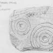
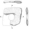
Scanned pencil survey drawing of cup and ring marked stone (in Rothesay Museum).
Records of the Royal Commission on the Ancient and Historical Monuments of Scotland (RCAHMS), Edinbu
14/10/2010
© Crown Copyright: HES

SC 1232039
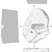
Scanned pencil survey drawing of cup marked stone from Kilmichael, Bute (now in Rothesay Museum)
Records of the Royal Commission on the Ancient and Historical Monuments of Scotland (RCAHMS), Edinbu
13/10/2010
© Crown Copyright: HES

SC 1232042
Scanned ink drawing of Kilchousland socket stone - plan view and 2 sections.
Records of the Royal Commission on the Ancient and Historical Monuments of Scotland (RCAHMS), Edinbu
14/10/2010
© Crown Copyright: HES

SC 1232049
Scanned Ink drawing of socket stone - plan view and 2 sections.
Records of the Royal Commission on the Ancient and Historical Monuments of Scotland (RCAHMS), Edinbu
14/10/2010
© Crown Copyright: HES

SC 1232090
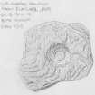
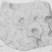
Scanned pencil survey drawing of cup marked fragment 1 from chambered cairn (now in Rothesay Museum)
Records of the Royal Commission on the Ancient and Historical Monuments of Scotland (RCAHMS), Edinbu
13/10/2010
© Crown Copyright: HES

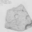
SC 1232093
Scanned pencil survey drawing of cup marked fragment 2 from chambered cairn (now in Rothesay Museum)
Records of the Royal Commission on the Ancient and Historical Monuments of Scotland (RCAHMS), Edinbu
13/10/2010
© Crown Copyright: HES

DP 098059
Detail view of the carved stone, taken from the SW.
Records of the Royal Commission on the Ancient and Historical Monuments of Scotland (RCAHMS), Edinbu
28/10/2010
© Crown Copyright: HES

DP 098123
View of socket-stone.
Records of the Royal Commission on the Ancient and Historical Monuments of Scotland (RCAHMS), Edinbu
31/3/2010
© Crown Copyright: HES

DP 098124
General view of socket-stone from S
Records of the Royal Commission on the Ancient and Historical Monuments of Scotland (RCAHMS), Edinbu
31/3/2010
© Crown Copyright: HES

DP 098135
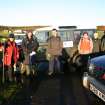
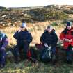
Scalpsie, Bute. From left to right: B Paterson, G Brown, D Dutton, J Sanders, I Mcarthur, J Macmillan, D Kinnear, A Hannah.
Records of the Royal Commission on the Ancient and Historical Monuments of Scotland (RCAHMS), Edinbu
12/2008
© Crown Copyright: HES

DP 098136
Bute volunteer I Mcarthur
Records of the Royal Commission on the Ancient and Historical Monuments of Scotland (RCAHMS), Edinbu
12/2008
© Crown Copyright: HES

DP 098137
Bute: RCAHMS staff and volunteers from left to right: D Dutton, B Paterson, A Hannah, I Mcarthur, B Shields.
Records of the Royal Commission on the Ancient and Historical Monuments of Scotland (RCAHMS), Edinbu
12/2008
© Crown Copyright: HES

DP 098138
Bute, RCAHMS staff and volunteers: J Sanders, B Paterson, D Dutton, G Brown.
Records of the Royal Commission on the Ancient and Historical Monuments of Scotland (RCAHMS), Edinbu
12/2008
© Crown Copyright: HES

DP 098139
Bute, volunteers A Hannah, I Mcarthur, D Kinnear.
Records of the Royal Commission on the Ancient and Historical Monuments of Scotland (RCAHMS), Edinbu
12/2008
© Crown Copyright: HES

DP 098945
View of White Hill cup marked stone, taken from the W.
Records of the Royal Commission on the Ancient and Historical Monuments of Scotland (RCAHMS), Edinbu
28/9/2010
© Crown Copyright: HES

DP 098946
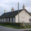
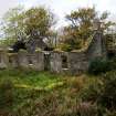
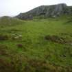
View of the bracken grown site of the building, taken from the N.
Records of the Royal Commission on the Ancient and Historical Monuments of Scotland (RCAHMS), Edinbu
16/9/2010
© Crown Copyright: HES

DP 098949
Detail view of rock shelter, taken from N.
Records of the Royal Commission on the Ancient and Historical Monuments of Scotland (RCAHMS), Edinbu
15/10/2010
© Crown Copyright: HES

DP 098961
General view taken from the N.
Records of the Royal Commission on the Ancient and Historical Monuments of Scotland (RCAHMS), Edinbu
31/3/2010
© Crown Copyright: HES

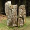
DP 098962
Detail of the N stone, taken from the W.
Records of the Royal Commission on the Ancient and Historical Monuments of Scotland (RCAHMS), Edinbu
31/3/2010
© Crown Copyright: HES

DP 098963
Detail of the middle stone, taken from the W.
Records of the Royal Commission on the Ancient and Historical Monuments of Scotland (RCAHMS), Edinbu
31/3/2010
© Crown Copyright: HES

DP 098964
Detail of the S stone, from the N.
Records of the Royal Commission on the Ancient and Historical Monuments of Scotland (RCAHMS), Edinbu
31/3/2010
© Crown Copyright: HES

DP 098967
View from the W.
Records of the Royal Commission on the Ancient and Historical Monuments of Scotland (RCAHMS), Edinbu
14/9/2010
© Crown Copyright: HES

DP 099935
General view of Glenvoidean cairn, from the N.
Records of the Royal Commission on the Ancient and Historical Monuments of Scotland (RCAHMS), Edinbu
5/10/2010
© Crown Copyright: HES

DP 099936
View of Glenvoidean cairn, from the N.
Records of the Royal Commission on the Ancient and Historical Monuments of Scotland (RCAHMS), Edinbu
5/10/2010
© Crown Copyright: HES

DP 099937
View of the cauldron during survey, taken from the NE.
Records of the Royal Commission on the Ancient and Historical Monuments of Scotland (RCAHMS), Edinbu
20/10/2010
© Crown Copyright: HES

DP 099938
View of the cauldron during survey, taken from the NW.
Records of the Royal Commission on the Ancient and Historical Monuments of Scotland (RCAHMS), Edinbu
20/10/2010
© Crown Copyright: HES

DP 099939
View of the cauldron during survey, taken from the SW.
Records of the Royal Commission on the Ancient and Historical Monuments of Scotland (RCAHMS), Edinbu
20/10/2010
© Crown Copyright: HES

DP 099942
Grave marker, view from the S.
Records of the Royal Commission on the Ancient and Historical Monuments of Scotland (RCAHMS), Edinbu
1/10/2010
© Crown Copyright: HES

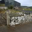
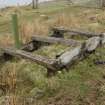
DP 099941
This cart or sledge may have been used to transport clay to the brickworks.
Records of the Royal Commission on the Ancient and Historical Monuments of Scotland (RCAHMS), Edinbu
31/3/2010
© Crown Copyright: HES

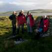
DP 099943
I Parker (RCAHMS) and volunteers visiting the St Ninian's Point east well.
Records of the Royal Commission on the Ancient and Historical Monuments of Scotland (RCAHMS), Edinbu
15/6/2011
© Crown Copyright: HES

DP 099944
View from the W.
Records of the Royal Commission on the Ancient and Historical Monuments of Scotland (RCAHMS), Edinbu
16/9/2010
© Crown Copyright: HES

DP 099949
View of Lenihall farmstead, taken from the E.
Records of the Royal Commission on the Ancient and Historical Monuments of Scotland (RCAHMS), Edinbu
24/11/2010
© Crown Copyright: HES

DP 099945
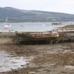
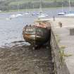
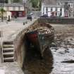
View of Co-worker lying against Port Bannatyne pier, taken from the W.
Records of the Royal Commission on the Ancient and Historical Monuments of Scotland (RCAHMS), Edinbu
16/9/2010
© Crown Copyright: HES

DP 099946
View from the S.
Records of the Royal Commission on the Ancient and Historical Monuments of Scotland (RCAHMS), Edinbu
16/9/2010
© Crown Copyright: HES

DP 099947
View from the N.
Records of the Royal Commission on the Ancient and Historical Monuments of Scotland (RCAHMS), Edinbu
16/9/2010
© Crown Copyright: HES

DP 099948
I Parker (RCAHMS) and volunteers visit the St Ninian's Point west well.
Records of the Royal Commission on the Ancient and Historical Monuments of Scotland (RCAHMS), Edinbu
15/6/2010
© Crown Copyright: HES

DP 099964
View of southern cairn, taken from the WSW.
Records of the Royal Commission on the Ancient and Historical Monuments of Scotland (RCAHMS), Edinbu
5/10/2010
© Crown Copyright: HES

DP 099952
View from the SW.
Records of the Royal Commission on the Ancient and Historical Monuments of Scotland (RCAHMS), Edinbu
16/9/2010
© Crown Copyright: HES

DP 099953
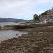
View of Port Bannantyne from the W.
Records of the Royal Commission on the Ancient and Historical Monuments of Scotland (RCAHMS), Edinbu
16/9/2010
© Crown Copyright: HES

DP 099954
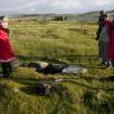
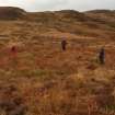
I Parker (RCAHMS) and volunteers show the outline of the hut circle at Muclich Hill.
Records of the Royal Commission on the Ancient and Historical Monuments of Scotland (RCAHMS), Edinbu
14/10/2010
© Crown Copyright: HES

DP 099955
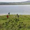
View of Inchmarnock cairn from the S.
Records of the Royal Commission on the Ancient and Historical Monuments of Scotland (RCAHMS), Edinbu
3/6/2010
© Crown Copyright: HES

DP 099956
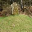
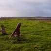
General view of the St Ninian standing stones, taken from the N,
Records of the Royal Commission on the Ancient and Historical Monuments of Scotland (RCAHMS), Edinbu
24/11/2010
© Crown Copyright: HES

DP 099957
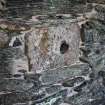
Detail of gun loop.
Records of the Royal Commission on the Ancient and Historical Monuments of Scotland (RCAHMS), Edinbu
15/9/2010
© Crown Copyright: HES

DP 099958
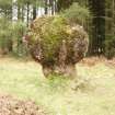
View of Glecknabae cairn, taken from the NE.
Records of the Royal Commission on the Ancient and Historical Monuments of Scotland (RCAHMS), Edinbu
16/9/2010
© Crown Copyright: HES

DP 099959
Detail of the cist on the W side, taken from the N.
Records of the Royal Commission on the Ancient and Historical Monuments of Scotland (RCAHMS), Edinbu
16/9/2010
© Crown Copyright: HES

DP 099960
View of Glecknabae cairn, taken from the E.
Records of the Royal Commission on the Ancient and Historical Monuments of Scotland (RCAHMS), Edinbu
16/9/2010
© Crown Copyright: HES

DP 099961
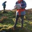
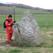
Georgina Brown of RCAHMS surveying at Ettrick stone circle.
Records of the Royal Commission on the Ancient and Historical Monuments of Scotland (RCAHMS), Edinbu
1/4/2010
© Crown Copyright: HES

DP 099965
View of northern cairns, taken from the N.
Records of the Royal Commission on the Ancient and Historical Monuments of Scotland (RCAHMS), Edinbu
5/10/2010
© Crown Copyright: HES

SC 1237715
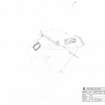
RCAHMS survey drawing; Barefield Farmsteading, ground plan.
Records of the Royal Commission on the Ancient and Historical Monuments of Scotland (RCAHMS), Edinbu
12/10/2010
© Crown Copyright: HES

SC 1237740
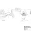
RCAHMS survey drawing; Kirk Dam, Rothesey, site plan
Records of the Royal Commission on the Ancient and Historical Monuments of Scotland (RCAHMS), Edinbu
10/2011
© Crown Copyright: HES

DP 101813
View from WNW.
RCAHMS Field Survey Digital Photography
15/3/2010
© Crown Copyright: HES

DP 101814
View from NNW.
RCAHMS Field Survey Digital Photography
15/3/2010
© Crown Copyright: HES

DP 101815
View from NE.
RCAHMS Field Survey Digital Photography
15/3/2010
© Crown Copyright: HES

DP 101816
View from SE.
RCAHMS Field Survey Digital Photography
15/3/2010
© Crown Copyright: HES
First 100 images shown.
