
Following the launch of trove.scot in February 2025 we are now planning the retiral of some of our webservices. Canmore will be switched off on 24th June 2025. Information about the closure can be found on the HES website: Retiral of HES web services | Historic Environment Scotland
Arran, Auchengallon


Cairn (Neolithic) - (Bronze Age), Stone Circle (Neolithic) - (Bronze Age)
Site Name Arran, Auchengallon
Classification Cairn (Neolithic) - (Bronze Age), Stone Circle (Neolithic) - (Bronze Age)
Alternative Name(s) Auchagallon
Canmore ID 39228
Site Number NR83SE 1
NGR NR 89287 34646
Datum OSGB36 - NGR
Permalink http://canmore.org.uk/site/39228


- Council North Ayrshire
- Parish Kilmory
- Former Region Strathclyde
- Former District Cunninghame
- Former County Buteshire
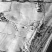
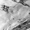
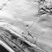
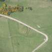
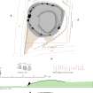
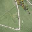
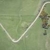
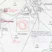
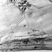
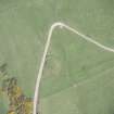
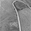
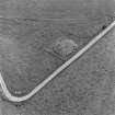
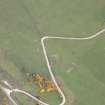
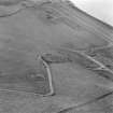
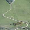
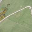
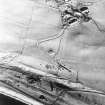
Aerial Photography (1970)
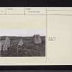
Oblique aerial photographs of Auchagallon stone circle and cairn, Arran, taken by John Dewar in 1970.
Desk Based Assessment (28 June 1977)
NR83SE 1 8928 3464.
(NR 8929 3463) Cairn and Circle (NR).
OS 6" map, Buteshire, 2nd ed., (1924)
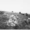
Auchagallon Stone Circle: This monument consists of a Bronze Age burial cairn, surrounded by a circle of 15 standing stones, 47ft in diameter
(S Piggott 1970). The ONB surveyor (1864), however, states that the interior of the stone circle is filled with loose stones gathered from the adjacent fields; the examiner has inserted "a cairn of water-worn pebbles". Balfour (1910), quoting Mr Sim, an old local inhabitant, states that though the standing stones appear to enclose a cairn, in Mr Sim's youth, the enclosed area was flat and free of stones. He also remembered the centre of the circle being excavated "many years ago", when a cist was found. He could give no information regarding its contents.
A flint core found near this monument was donated to the NMAS in 1973-4.
Information from OS (IF) 28 June 2018.
Sources: Name Book 1864; J Balfour 1910; Proc Soc Antiq Scot 1975.
Field Visit (10 October 1977)
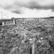
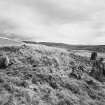
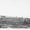
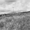
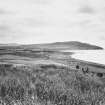
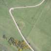
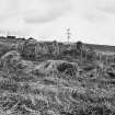
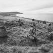
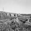
NR 8928 3464. This 'stone circle and cairn' is situated on a slight ledge of a W-facing slope.
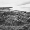
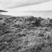
The 'circle' comprises fifteen earthfast sandstone blocks varying in height from 0.5m to 2.3m with one stone flush with the cairn suface. Conspicuous gaps in the E and S sides suggest other stones are missing or buried. On the E side, two 'rogue' stones upset an otherwise elliptical shape, measuring overall 14.5m NW-SE by 13.0m NE-SW.
It is doubtful that the compacted mass of turf-covered stones that form the cairn could be of entirely recent origin. There is obvious dumping on the S and E sides where the grassed slopes overlap the stone line in haphazard fashion, but the overall impression is of a cairn, 2.0m high on the W side, retained and preserved by the closely spaced stones on the N and W sides.
Re-surveyed at 1:2500. Photographed.
Visited by OS (JRL) 10 October 1977.
Note (1 October 1977)
Auchagallon Stone Circle; probably the remains of a kerbed round cairn.
Source: R McLellan 1977.
Publication Account (1985)
The interpretation of this monument is somewhat problematical: it is frequently described as a stone circle, but is more likely to be a localised type of cairn dating from the second or third millennium BC. At present the site consists of a low mound of stones about 13.5m in diameter surrounded by an intermittent ring of boulders. These arc graded in height with the smaller stones lying on the east and five particularly large stones set on the west, close to the track. 19th century records show that the intelior has been disturbed and that at one time it was clearer of stones than it is today.
Without excavation it is impossible to disentangle the complex histories of sites such as Auchagallon, and it is all too easy to try to pigeon-hole them into existing schemes of classification. The wide range in the heights of the stones of the ring indicates that it is not a true stone circle in the normally accepted sense, and on balance, the grading of the stones, their intemlittent spacing and the presence of a mound suggests that the site is a cairn dating to the late neolithic or early bronze age. For another example of this Arran type of cairn sce Moss Farm Road (no. 95.1).
Information from ‘Exploring Scotland’s Heritage: The Clyde Estuary and Central Region’, (1985).
Publication Account (3 December 2008)
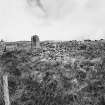
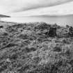
This unusual cairn, which is a Guardianship Monument in the care of Historic Scotland, stands within a fenced enclosure beside the track leading up to Auchagallon. It is set towards the rear of a sloping terrace commanding fine views southwards to Machrie Moor, though the design of what is either a freestanding stone circle or a kerb of tall orthostats faces westwards over the sea to the Kintyre peninsula. The circle is made up of fourteen stones, all but two (10 and 9) apparently in situ, and measures about 15m in overall diameter. The spacing of the stones is irregular and there are plainly gaps where some are missing. Nevertheless, they appear to be graded in height, rising from the shortest in the east to the tallest on the west, where there is an imposing set of three (1–3) that are reminiscent of a recumbent setting, with two tall orthostats 1.6m and 2.2m in height placed to either side of a block measuring 1.65m in length by 1.2m in thickness and up to 1.8m in height. In keeping with recumbents in the North-east, the central block has a relatively flat and level summit, but in contrast it is both taller than it is long and the stones to either side do not stand flush with its ends. All three lean back into the cairn, which rises steeply behind them, and their external heights are far greater than any internal measurement. Of the other orthostats, one on the east-north-east (10) remains earthfast but barely rises above the surface of the ground and may be a broken off fragment, while another on the east-south east (9) has probably fallen inwards. The latter is of granite, whereas the rest are red sandstone. Unusually, the axis of stone 14 on the north-west is set at right-angles to the circumference of the ring. The cairn is now largely grass-grown, with a broad flat summit that rises marginally higher than the tallest orthostat on the west. Set on such steep ground, it presents a long talus of cairn material sloping down to the south, which subsumes the lower portions of stones 6 and 7, and may well hide any other lesser slabs around this side. The origin and antiquity of the cairn, however, are of some debate (see below).
Auchagallon may be one of the Druidical circles first mentioned by Rev Alexander Macbride of North Bute (NSA, v, Buteshire, 52), but it is not described in any detail until 1864, when the OS surveyors were preparing the 1st edition of the 6-inch map (Buteshire 1869, ccxlviii). By then the surrounding ground had been improved but the accompanying Name Book entry describes it as ‘one of the most perfect cairns or circles … to be found on the island ’ (Buteshire, No. 2, p 30).
Even then its classification was problematical, and the proposed annotation Stone Circle is partly erased in favour of Cairn and Circle, which duly appeared upon the published map. The entry reveals that fourteen sandstone uprights were visible ‘surrounding a cairn of water worn large pebbles ’, but a note added by the officer in charge also records that the ‘interior is now filled up several feet higher than the adjacent land with loose stones gathered from the ploughed fields ’ (ibid). The depiction is essentially unchanged on the 2nd edition of the OS map, but by then the cairn that had stood some 50m to the north had been removed (Buteshire 1895, ccxlviii).
Just how far field clearance has contributed to the make-up of the cairn remains unresolved. When Thomas Bryce wrote about it at the beginning of the 20th century, he was told by Archibald Sim, who had been the tenant at Auchagallon, ‘that in his youth the enclosed area was flat and free of stones. The ground is cultivated all round the circle, and the stones gathered from the fields have been piled year after year within it, until now a number of the upright stones are actually hidden below them ’ (Bryce 1910, 119). Sim also remembered ‘seeing the circle excavated at the centre many years ago ’ (ibid); this revealed a stone cist, though he was unable to furnish any details of its contents. According to census records Sim was born at Tormore in 1827, less than 2.5km to the south, and had moved a little further south to Drumadoon by 1841, but from at least 1881 he was the farmer at Auchagallon. As such he may have been responsible for clearing the cairn to the north and depositing some of the clearance within the circle. Bryce evidently had sufficient belief in this account that he was dissuaded from mounting an excavation in the ring, and there seems no reason to doubt that a substantial portion of the mound here today is made up of cleared stones. The flattened arc of the cairn on the north-east and the absence of any upright stones there (9 and 10) perhaps shows where carts gained access into the interior to dump them, and this in turn may explain why the summit of the cairn is off-set to the south-east and the talus on the south subsumes the two orthostats on this side (6 and 7). Others have been more sceptical and Robert McLellan, who wrote a guidebook to the ancient monuments of Arran, suggests that Sim ‘had something to hide, for there were few farmers with access to these monuments in the first few decades of the nine-teenth century who did not rob them of stone ’ (1977, 32). This, however, has no actual bearing on the issue, and the real question is whether the cairn described by the OS surveyors in 1864 contained the residue of an earlier mound. The discovery of a cist at the centre perhaps suggests that it did, though other burials in the centres of circles on Machrie Moor were not covered by cairns.
Bryce’s description is accompanied by a plan by Angus McAllister and a photograph from the north-northwest showing the mass of stones within the interior (1910, fig 41). He opens with the statement that ‘this magnificent circle … consists of fifteen blocks, for the most part of red sandstone ’ (1910, 119–20), and provides a table giving the dimensions of each stone. Assuming each stone was measured consecutively, a comparison with the measurements gathered in the course of the present survey indicates that he began with the stone on the south-west (5) and then worked clockwise around the ring. The sequence only breaks down on the north-north-east (11) and it is difficult to correlate the stones on the east with any conviction, not least because the last six stones in Bryce’s table lack at least one measurement. The problem is exacerbated by McAllister’s plan, which shows only fourteen stones and none of these are numbered (Bryce 1910, 120, fig 59). Over the years, commentators have laboured over the classification of this monument, with opinion ranging from an encircled cairn (McArthur 1873, 14) to simply a stone circle (McLellan 1977, 31) or cairn (Stevenson 1995, 156). Most have drawn attention to the grading in the heights of the stones, their irregular spacing, and the presence of an internal cairn or mound of stones (eg Barnatt 1989, 242; Stevenson 1995, 156), but Horace Fairhurst was amongst the first to draw a formal connection between the architecture of Auchagallon and recumbent stone circles; the block on the west, he noted, was ‘closely fitted between the other two and has a relatively flat top ’ (1981, 33). Burl’s views evolved in parallel, at first likening the ‘recumbent kerbstone ’ to the false portals then recently discovered in Argyll at Kintraw and Culcharron (Burl 1976a, 147, 171). His subsequent guidebook entry employs the term flanker and concludes that the ring ‘could be a variant form of recumbent stone circle ’ (Burl 1995, 113); more recently still he has emphasised the features Auchagallon shares with recumbent stone circles, citing ‘The combination of an internal cist and possible cairn, south-westerly orientation and recumbent slab ’ (2000, 92). The circle, he suggests, ‘is arguably an ill-remembered copy of the recumbent stone circles of Aberdeenshire ’ (ibid 90). There is no doubt that the three stones on the west have a passing resemblance to a recumbent setting, but the likenesses can be overstated. Not only are they facing due west, an orientation otherwise unknown in recumbent stone circles, but (as has been indicated) the block is taller than it is long, while the flanking orthostats are set apart from it, again a feature unknown in the North-east. There may well have been a cairn in the interior; a central cist, if indeed it was central, is unparalleled in recumbent stone circles, finding much better comparisons closer to home on Arran. The only cists known from recumbent stone circles are those from Corrie Cairn and just beyond the margin of Loanhead of Daviot. The approach taken by the present survey concurs with Jack Stevenson in not wishing to pigeon-hole Auchagallon into any particular scheme of classification (1995, 156–7), particularly as it stands on the fringes of one of the most extraordinary concentrations of stone circles in Scotland, exhibiting a wide range of architectural features that include grading, the construction of cairns and the presence of central cists.
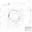
Measured Survey (3 December 2008)
RCAHMS surveyed Auchengallon cairn on 3 December 2008 with plane table and alidade producing a plan and sections of the site and an elevation of stones 1,3 and 3 at a scale of 1:100. The plan, sections and elevation were used as the basis for an illustration, produced in ink and finished in vector graphics software, that was published at a scale of 1:250 (Welfare 2011, 494).
Change Of Classification (10 December 2008)
Classification amended from Cairn and Stone Circle to Recumbent Stone Circle.
Information from RCAHMS (ARG) 10 December 2008
Change Of Classification (15 June 2010)
Classification return to Cairn and Stone Circle as subtle differences distinguishes this site from the recumbent stone circles of NE Scotland.
Information from RCAHMS (ATW) 15 June 2010
Airborne Laser Scanning Interpretation (11 July 2018)
The location, classification and period of this site have been reviewed.
HES Survey and Recording 11 July 2018
Barber 1997

