Following the launch of trove.scot in February 2025 we are now planning the retiral of some of our webservices. Canmore will be switched off on 24th June 2025. Information about the closure can be found on the HES website: Retiral of HES web services | Historic Environment Scotland
HES Archaeological Survey: Isle of Arran Phase 1


Date 2017 - 2019
Event ID 1036806
Category Project
Type Project
Permalink http://canmore.org.uk/event/1036806
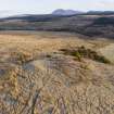
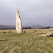
An archaeological survey of the Isle of Arran was undertaken by Historic Environment Scotland, Survey and Recording, in 2017-18. The survey specification was designed to ensure rapid coverage and to meet the minimum requirements for data entry into the National Record of the Historic Environment (NHRE, https://canmore.org.uk/content/what-should-you-find-canmore-record). Location (as a centre point and a site area polygon), classification (s), and period were recorded in line with the specification for Level 2 in the HES Levels of Survey. The survey made extensive use of Airborne Laser Scanning (ALS) data to support a phase of desk-based mapping that preceded fieldwork. The ALS data for Arran was commissioned by a consortium led by the Scottish Government and gathered by Fugro between November 2012 and April 2014 (Phase II data), providing an overall point density of 4.67/m2 and an average ground point density of 2.95/m2 (https://remotesensingdata.gov.scot/). The ALS data was processed by Žiga Kokalj (Research Centre of the Slovenian Academy of Sciences and Arts) from LAS files to generate a digital terrain model (DTM) with 0.5 m spatial resolution. This was used to produce DTM visualisations using the Relief Visualisation Toolbox (https://iaps.zrc-sazu.si/en/rvt#v).
Desk-based mapping in late 2017 and early 2018 was undertaken by nine Survey and Recording staff, with a focus on the identification of previously unknown sites. Multiple ALS-derived visualisations (Hillshades; Local Dominance; Negative Openness; Positive Openness; Slope aspect; Simple Local Relief Model; Sky-view Factor) and three composite visualisations (Sky-view Factor superimposed on Slope aspect, and Multiple Hillshade; Sky-view Factor superimposed on Positive Openness, Slope aspect, and Simple Hillshade; Color-coded DTM superimposed on Local Dominance, and Simple Hillshade) were used to identify sites and targets with a polygon supported by classifications and a level of confidence in the interpretation, ranked from 1 (high) to 3 (low). Colour orthophotographs taken in 2004 and 2010 (supplied by Getmapping) and Ordnance Survey 1st and 2nd edition maps were made use of to varying degrees.
The second stage of the project comprised six weeks in the field for six staff between late February and mid-May 2018. Fieldwork was directed to checking the lower confidence level 2 and 3 identifications, specifically in the hope that field observation would improve confidence in the interpretation. Patterns of walking that explored gaps in coverage were also encouraged, with the routes of all staff documented by GPS recorded tracks. In total some 500 newly discovered sites have benefited from a field visit, with 152 sites discovered solely through field investigation. Previously known sites were not generally visited.
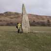
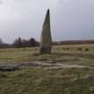
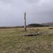
Following fieldwork all site area polygons and classifications for in-scope sites already on record were reviewed and updated as required, with all newly identified sites entered to the NRHE. The survey identified 898 previously unknown sites, more than doubling the number of in-scope (i.e. those with an earthwork expression) archaeological monuments known on Arran, with some 700 previously known monument records upgraded through creation of site area polygons and selective changes to classifications. The new identifications include nearly 100 prehistoric settlement sites, just under 200 shieling hut groups and a cursus monument (NR82NE36). Some 345 digital photographs captured during fieldwork have been added to the NRHE. The survey archive includes the GIS shapefiles created during desk-based mapping and subsequent survey data processing, the GPS recorded tracks of field walking, and the metadata for the ALS processing and visualisations.
Information from HES, Survey and Recording (DCC) 9 October 2019