
Islay, Dunyvaig Castle


Castle (Medieval)
Site Name Islay, Dunyvaig Castle
Classification Castle (Medieval)
Alternative Name(s) Dunyveg; Dun Naomhaig; Dunivaig Castle
Canmore ID 38002
Site Number NR44NW 24
NGR NR 40606 45507
Datum OSGB36 - NGR
Permalink http://canmore.org.uk/site/38002


- Council Argyll And Bute
- Parish Kildalton And Oa
- Former Region Strathclyde
- Former District Argyll And Bute
- Former County Argyll
NR44NW 24 4059 4549.
(NR 4060 4547) Dun Naomhaig (NR)
OS 6" map, Argyllshire, 2nd ed., (1900)
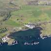
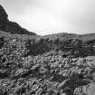
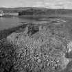
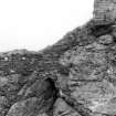
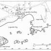
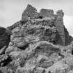
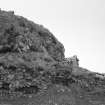
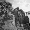
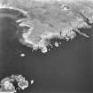
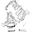
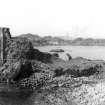
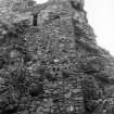
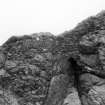
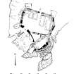
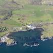
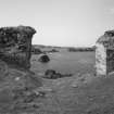
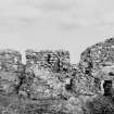
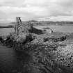
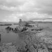
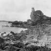
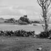
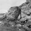
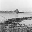
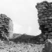
Dunyvaig Castle occupies a rocky promontory; on the summit of a high rock at the seaward end stands the remains of a high building, of which the seaward wall only still stands, the rest being reduced to overgrown foundations. SW of this, at a lower level, are the remains of a round bastion. W of the high rock is a small inner court, and a large outer court, 120ft E-W by 70ft within a curtain wall, 12ft thick on E and 7ft thick on W containing the foundations of rectangular buildings of varying sizes and a square well or tank in the NE corner, filled with rubbish. The NE and SW corners of the curtain have exterior foundations of a shape suggesting the former presence of ravelins. The N curtain has a central entrance; to the exterior are foundations of a possible barbican, and there is a 17ft wide sea-gate in the SW.
The masonry of most of the castle is of early West Highland type 13th century (OS 6" map annotated by A L F Rivet undated).
H B Miller and J Kirkhope 1964; Information from plan and photographs from H B Miller 1964.
The NSA (1845) implies that 'Dun Naomhaig or Dunivaig' may occupy the site of an earlier fort.
New Statistical Account 1845.
An anonymous account, written about 1630, describes 'Dunowaig' castle as an "ancient fortress but lately builded with castles and tours be James McDonnald".
W Macfarlane 1906-8.
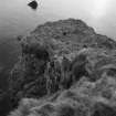
Dunyvaig Castle and Dun Naomhaig; names confirmed. Dunyvaig is the accepted local spelling; according to local information there was, until recently, a nameboard at the Castle. Dun Naomhaig is also the proper name, still in local use, for the castle tower on its isolated stack. There is no certain visual evidence for the prior existence of a dun; the undulating stack top has an occupiable area of very approximately 200 square metres.
The castle is generally as described and planned. The former dimensions and precise shape of the tower remains conjectural, and 'bastion' appears to utilize a narrow and rounded spur on the SW side of the stack. There is no extant walling around a central depression, but the sides and neck of the spur are neatly revetted.
The level outer court has the turf-covered footings of several rectangular structures butting against the N curtain wall. These may be contemporary with the court (though similar footings exist well outside) and castle to the north and could represent a later farmstead. The turf-covered wall lines of a probable barbican are clearly visible extending from the entrance, but there are no extant remains of the suggested ravelins at the NW and NE angles.
Re-surveyed at 1:2500.
Visited by OS (JRL) 24 June 1978.
Manuscript annotation on RCAHMS working map indicates 'several two-celled outbuildings. ?also possible siegeworks'.
(Undated) information in NMRS.
Non-Guardianship Sites Plan Collection, DC23457.
Field Visit (August 1976)
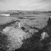
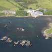
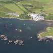
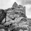
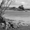
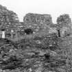
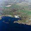
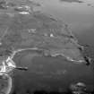
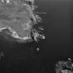
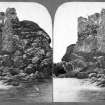
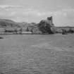
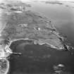
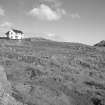
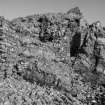
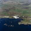
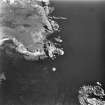
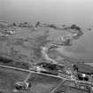
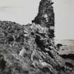
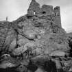
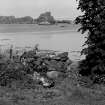
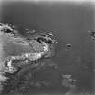
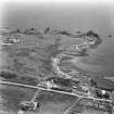
NR 405 454. The ruins of this stronghold stand on a coastal promontory on the E side of Lagavulin Bay, guarding the entrance to the anchorage there and commanding a distant prospect of the coasts of Kintyre and Antrim. The existing remains comprise an outer courtyard or barmkin of irregular polygonal layout situated on low-lying ground immediately to the N of the rocky knoll at the tip of the promontory. The summit of this knoll, which stands to a height of about 14m above high- water mark and is partly composed of epidiorite, is surrounded by vestiges of an enclosure-wall. It is crowned by the SE or seaward side-wall of a substantial building of elongated hall-like proportions which survives to a height of more than two main storeys. The upper and lower levels of the castle are linked by the remains of a stair which ascends from a small inner courtyard and traverses the site of a bridge built against the W face of the rock outcrop. The walls of the outer enclosure survive to a maximum visible height of 5.6m in the vicinity of a SW sea-gate, and other lengths of courtyard
Summary
The surviving fabric of the hall-building on the summit shows clear indications of at least one major phase of reconstruction, the original building-period probably falling within the early decades of the 16th century, and the reconstruction within the latter half of the same century. It overlies part of the circuit of a wall which follows a natural line of defence round the irregular outline of the summit area. This wall has itself undergone some reconstruction, especially where it underpins the main building, and, to judge from this local sequence of construction, it is probable that some lengths of wall formed part of the 'castrum Dounowak' mentioned by Fordun in the later 14th century (en.1). The outer courtyard appears to be substantially of 16th-century construction, and the visible modifications and repairs were probably carried out in the early 17th century.
The surviving visible portions of the castle thus appear to date mainly from the period after 1545 when it was regranted to its former owners, the MacDonalds of Dunivaig and the Glens (Co. Antrim). Deprived by the Crown of their possession of the castle after 1597, the later members of this family sought to wrest control of it from successive royal agents, and in the early years of the 17th century the castle was the centre of much military and political activity. The defences sustained a good deal of damage at this time, especially in the famous siege by royal forces under Sir Oliver Lambert in 1615, and, following a further siege by rebels in 1630, the castle survived a threat of demolition by its then owner, John Campbell of Cawdor. The last recorded episode in the building's military history was the successful siege of its Royalist garrison by General David Leslie in 1647.
Architectural Description.
The walls throughout are constructed of lime-mortared random-rubble masonry comprising slabs and split boulders of local extraction. The dressings of 'bluestone' or epidiorite which make up the slab lintels and jambs of the windows in the upper range are also of local origin. The windows of this building preserve some rybats of a fine-grained whiteish-coloured sandstone, and three dressed stones of similar character were recovered from an area of the foreshore SW of the sea-gate (en.2).
Outer Courtyard.
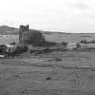
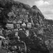
This irregular seven-sided enclosure occupies the full width of the promontory, and the flanking E and W curtain-walls, which possess angled salients, rise directly above the boulder strewn foreshore on each side. The courtyard measures 37m in maximum internal length by 23m transversely, and the thickness of the curtain-wall varies from slightly more than 2m to 3m at the E flank and turf-covered N front. The W curtain-wall has a pronounced external batter, whilst the surviving facework of the E curtain and N front-wall is battered only at base. At the NW and NE angles there are foundations of a pair of angle-turrets or bastions which were laid out but probably never completed, that at the NE angle being backed by a blocked-up loop in the main curtain.
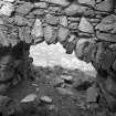
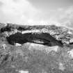
The principal gateway is placed near the centre of the landward or N curtain-wall. A detailed account of the siege of 1615 referred to the battering of a tower in which the rebelles held a gaurd over the porte that entereth the outeward bawne' (en.3), implying that the entry, if not actually towered itself, was certainly protected by a tower. The vestigial traces of the gateway suggest an opening about 1.8m in width, and there are footings of a gatehouse extension or barbican immediately to the N. The gateway is flanked on the E by what appears to have been an intramural passage and a stair giving access to a parapet-walk. Within the thickness of the curtain-wall to the W of the entry is the upper part of a small partly circular and dome-vaulted chamber, reached apparently from one of the courtyard buildings (C), and now almost completely infilled. The original height and character of this chamber cannot be ascertained without excavation, but it may have been an oven. This may have been the feature that led an earlier commentator to identify one of the courtyard buildings, presumably C, as 'a baker's house' (en.4).
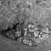
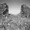
Within the courtyard and for the most part abutting the inner face of the N curtain there are the low turf-covered remains of four rectangular buildings (A-D) and what appears to be an open-ended shed (E). The buildings are aligned roughly NE-SW, and the visible portions of the walls are of drystone construction varying between about 0.6m and 1m in thickness. The two larger structures (A, B) occupy the E half of the courtyard and are grouped around an oblong drystone shaft, possibly a well, in the NE corner. The shaft measures 1.6m by 1.3m across the mouth and about 1.5m in visible depth. Building A, the eastern most of the group, measures 10.3m by 4.3m internally and has an entrance near the centre of the NW side-wall. Building B, which flanks the main entrance, measures 11.6m by 3.9m, and there are possible entrances in both the W and S walls; the SW angle is noticeably rounded. On the opposite side of the entrance-passage there is the comparatively well-preserved building C that incorporates the mural vault noted above. Internally it measures 6.5m in length by 3.75m transversely and there is an entrance at the S end of the E side-wall. Building D is of similar dimensions, and was entered through a doorway in the S end-wall. The adjacent structure (E) is of indeterminate character, measuring 3.4m across the open SW end by 2.9m in maximum internal length.
At the SW angle of the courtyard there are the remains of a sea-gate which is fronted by a boat-landing formed partly between roughly parallel lines of boulders on the foreshore. This gateway, which has splayed ingoings, measures almost 6 m in width internally and can probably be identified as 'the arche, oute of which there [the rebels'] boate was launched into the sea' in 1615 (en.5). The actual portal and its external surround no longer survive, and between the existing gatepiers there are fragmentary wall-foundations; this suggests the possibility that the gate is an enlargement of an earlier and narrower opening in the same position. At the extreme W angle of the courtyard there is evidence of another gateway, now blocked up, incorporating outward-splayed jambs and a stepped external approach leading directly from the foreshore. The two-phase blocking has the appearance of a makeshift repair, and probably dates from one of the military episodes in the early 17th century. In the W curtain-wall there are the lintelled embrasures of two slits or loops, one in each flank of the angled salient. They possess both curved and straight ingoings but their external surrounds no longer survive. Vestiges of a blocked-up embrasure apparently of similar character can also be seen at the NE angle.
Inner Courtyard and Stair.
The mutilated and partly infilled remains of a gateway giving access to the upper levels of the castle are located in the S wall (en.6) of the outer courtyard. Its inner face has splayed ingoings and is ceiled by a segmental rubble vault, while a pair of mural sockets in the ingoings was probably designed to receive the timber head of an associated door-surround. The gateway opens into a roughly triangular enclosure situated immediately beneath the main crag, an area that probably corresponds with 'the inward bawne' to which Lambert alluded in 1615 (en.7). His report implies that the castle well also lay in this vicinity, but his own artillery bombardment 'yillded such aboundance of rewins and rubbidge' that the inner bawn and the well were 'chockt upp' and there is no reference to the well in a slightly later description of activities in and around the inner bawn (en.8). Against the outer face of the curtain-wall there are the remains of a buttress or platform, added probably to make good some of the damage incurred in 1615.
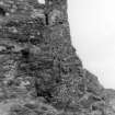
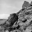
The site of a bridge, which is described in at least one account as 'the draw brig' (en.9), is marked by a 1.5m gap between a pair of substantial masonry abutments built against the W face of the main rock outcrop at the S angle of the inner courtyard. The upper or S abutment, which is based partly on natural rock and is drained by a weep-hole at base, stands almost intact to a height of 3.8m. A surviving corbel on its W side is probably one of a pair which supported a timber runner beneath the bridge, and the threshold is flanked by dwarf-walls rebated to receive an inward-opening gate. The remains of a narrow staircase ascend thence to a SW turret, and the fragmentary outer wall of the stair is interspersed with outcrops of rock. About 2m S of the bridge the wall is pierced by part of an embrasure of a slit or loop covering the sea-gate and boat-landing below.
The projecting SW turret or bastion is of roughly ovoid plan, measuring about 7m in maximum diameter over a grass-covered interior. It stands on a spur of rock below the level of the main summit, and appears to have served as a defensive platform of intermediate height protecting the W flank of the castle and immediately overlooking the mouth of Lagavulin Bay. A wall, which measures 1m in width and 5m in length, extends E from the turrets spanning a deep fissure in the rock and thence rising to the summit where it abuts the wall that underlies the main superstructure. About midway along its length the inner face of this link-wall is itself abutted by a 2m stretch of walling forming a minor platform between the turret and the main summit.
Summit Area.
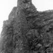
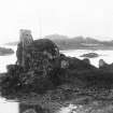
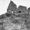
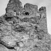
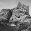
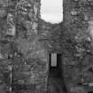
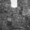
The remains of a lime-mortared wall follow the irregular configuration of the summit area, and the best-preserved length of walling is a curved stretch in the NW section. On the S side the curtain extends beyond the face of the standing building and returns beneath the oversailing SW angle, which is boldly cantilevered on a series of slab-corbels. At the SE angle the building is carried on a lofty and battered substructure or buttress, whose random-rubble masonry contrasts with the partly coursed split boulders of the main wall-face. This S side-wall survives to an average height of two storeys, although a portion towards the W end stands slightly higher, and a latrine in the SE angle evidently served a third floor or parapet. There are fragmentary remains of the associated end-walls, while earth-covered mounds indicate the approximate position of the N side-wall. The main block thus appears to have been rectangular on plan, measuring internally 11.3m in length by about 6m transversely. The S side-wall is markedly wedge-shaped on plan, widening from a ground-floor thickness of 1m at the SW angle to 3.1m at the SE, where the extra thickness encroaches upon the internal floor-area.
The ground floor of the main block contains three slit-windows which have slab-lintelled embrasures with variously-angled splayed ingoings. The best-preserved E window has a deep and narrow tunnel embrasure, and the external surround is almost completely formed by monolithic slabs that contain sockets for a window-grille. In the SW angle there is a small aumbry containing a splayed drainage chute or slop sink which discharges over a crude projecting external spout. The fragmentary portion of the adjacent W end-wall, which measures 1.4m in thickness as compared to about 1m for the corresponding E wall, incorporates a straight ingo and the canted seating of an arch-springer above, probably a vestige of a kitchen fireplace. The floors were evidently timber-joisted, and a large corbel situated approximately midway along the inner face of the S wall probably supported a timber runner beneath the hearthstone of a fireplace above.
In the existing first-floor arrangement there is a centrally-placed 3m-wide mural recess which is almost certainly therear of a hall fireplace. It is flanked by a pair of splayed window-embrasures whose external surrounds incorporatesandstone rybats of the kind noted above. A rybat of the westernmost first-floor window is rebated internally andwrought with a 90 mm chamfer on the external arris. Two blocked-up windows with crude square-arrised rubble jambscan be seen in the external wall-face behind the fireplace.
The remains of an E annexe are represented at the SE angle by the stub of an obliquely aligned wall which incorporates of a garderobe system. At first-floor level there are the blocked-up remains of a small box-garderobe projected on slab-corbels and formerly lit by slit-windows in the E wall. Its outer wall incorporates a discharge-chute from a latrine serving the floor above, and the mural recess at ground level may also have been part of this series of garderobes.
Later Settlement and Siege Works.
The foundations of groups of small two- and three-roomed buildings of 18th-century or later date lie within the vicinity of the NE approach to the castle, and much of the promontory shows evidence of turf-dyking, drainage and ploughing, all presumably a result of land use in the period following the abandonment of the castle.
Descriptions of the siege of February 1615 refer to the preparation of an artillery platform and adjacent trenches placed 'in the moist commodious pairts round abowt the castell so as thair was no hoip for the rebelles to eshaipe the land' (en.10). Over 200m ENE of the castle there is a large i rectangular and partly scarped platform which dominates the landward approaches to the castle and is now partly occupied by a modern house. Early editions of the OS map show that the platform preceded the construction of this house, and it may have originated at the time of the 1615 siege, this site lying well within the range of the ordnance employed on that occasion.
Historical Note.
This site has probably invited occupation and fortification from at least the Early Historic period, but the first specific reference to a castle of Dunivaig was made by the chronicler John of Fordun in the later 14th century. About that period possession of the stronghold passed from the Lords of the Isles to a cadet branch of the family, the MacDonalds of Dunivaig and the Glens, who held the castle until after their rebellion and forfeiture in 1494. Thereafter, Dunivaig and much of Islay were held with royal support by John Maclan of Ardnamurchan, who in 1514-16 took measures for the supply and defence of the castle in the face of a MacDonald insurrection. Upon his death in 1519 the 'keping of the hous of Dunnewig' was deputed by the Earl of Argyll to his brother. Sir John Campbell of Cawdor. The castle later became a direct possession of the Crown and was then regranted to James MacDonald of Dunivaig whose Scottish lands were formally erected into the barony of Barr in 1545 (en.11).
During the MacDonald-MacLean feud of the last quarter of the 16th century, and probably after 1586, Dunivaig wasbesieged on at least one occasion and, because of the obdurate behaviour of Angus MacDonald, King James VIfinally took the castle into royal custody in 1596/7. Commissions were issued to the same end in 1601 and 1605,and early in 1606 Angus was subjected to an act of caution for the maintenance of a royal garrison in the castle for aperiod of three months. Direct royal control was considered to be the best solution, however, and under threat of siege in 1608 Dunivaig was handed over to the royal lieutenants, Lord Ochiltree and Andrew Knox, Bishop of the Isles. Agarrison consisting of a captain and 24 soldiers was housed there, and in 1610, when Dunivaig was granted as a life-rent to the bishop to be maintained at his own expense, the incumbents were required to 'deliver upoun inventorie all suche poulder, bullet, musket and other warfar provision as was left unto thame for keping of the same house' (en.12).
In April 1614, according to information presented to the Council by Sir James, son of Angus MacDonald, the castlewas captured by a small band under Ronald Oig, 'a vagabound fellow without ony certane residence' who claimed to be a natural son of Angus MacDonald. In a wood nearby they evidently made some ladders with which they scaled the outer wall, and when the castle gates were opened they took the house and ousted the bishop's small garrison.Shortly afterwards they themselves were besieged by Angus Oig MacDonald and Coil Ciotach MaeGillespie, and apparently after six days were compelled to escape 'at a bak yett in a litle boat with sex oares which lay at the castle' (en.13).Angus Oig thereupon refused to release his hold on the castle, placing Coil Ciotach in command of the garrison, and in the following September a military expedition under Bishop Knox failed to regain the stronghold. A punitive royal expedition under the overall command of Sir John Campbell of Cawdor was therefore planned in October, and in order toavoid a protracted siege an additional force of 200 soldiers and heavy ordnance were shipped from Ireland. The artillery was to be 'sufficient for the battery and forcinge of the said house of Dunevege, which wee are informed is a place of good strength, being strongly built of it seife, and, besides, it is compassed with iii stone walles, each of them conteyninge thirty and sixe feet in thickness'. The besieging force under Sir Oliver Lambert completed their artillery platform at the end of January 1615 and on 1 February began their bombardment of the castle, which failed to live up to its reputation. As Lambert later reported to King James VI, 'Three dayes batterye with the ordnance wee used was powerful to ruyne the whole howse, invincible without the canon and famyn' (en.14).
In accordance with the terms of the charter issued to Sir John Campbell of Cawdor in November 1614 Dunivaig Castle became the principal messuage of the newly erected barony of Islay. In the following June, however, it was recaptured by Sir James MacDonald, who claimed that he 'tooke it from Calderis menne in the speace of one day, killed part of thame vpone the greene of the house, chaised in the rest, tooke there waiter and two bannkines', and in another account of the same incident he added that he had set fire to the yett of the inner barmkin. It was later reported that MacDonald and his associates considered that Dunivaig was 'nocht hable to be manned', probably as a result of the'damage it had sustained earlier in the year, and in October Coil Ciotach, who had held the castle for Sir James, readily ceded possession of it to the Earl of Argyll before the siege artillery was landed on Islay (en.15).
The castle continued to serve, however, as the principal Campbell residence on the island and remained a symbolic focus for local disaffection. After an unsuccessful assault by a group of local rebels in 1630 the Privy Council agreed in the following year to John Campbell's petition 'to demolisce and cast downe the said hous to the ground, so as it serve not theirefter for a beild, ressett, or starting holl to the rebellis of the Ylles', a recommendation that King James VI had previously made to his father, Sir John. The proposal evidently remained unexecuted for in July 1647, after their commander. Coil Ciotach. had been captured during a parley, a Royalist garrison in the castle was able to offer short but stout resistance to a besieging army under General David Leslie and was ultimately able to secure favourable terms of surrender. Leslie commented in a despatch that his problems of food and munitions were compounded by 'th
Visited August 1976
RCAHMS 1984
Manuscript annotation on RCAHMS working map indicates 'several two-celled outbuildings. ?also possible siegeworks'.
(Undated) information in NMRS.
Measured Survey (1976)
RCAHMS surveyed Dunivaig Castle in 1976 and produced a location map (1:1000), a general site plan (1:400) and phased plans at ground and first floor level (1:200). The drawings were reproduced in ink and published at reduced scales (RCAHMS 1984, figs. 268, 269B, 270). A plan of the siege works (AGD 1005/1) was not reproduced.
Project (14 August 2017 - 19 August 2017)
NR 4059 4549 (NR44NW 24) An electrical resistance survey and a terrestrial 3D laser survey were undertaken, 14–19 August 2017, of the remains of Dunyvaig Castle and the immediate environs. This initial work is the beginning of the long term project into the castle’s history, which will include further survey of the environs and the hinterland and the excavation starting in August 2018.
The 3D laser scan survey was carried out by Aiji Castle of Topcon using a GLS-2000 Topcon laser scanner. It concentrated on the upstanding remains of the castle, which have not been examined since the RCAHMS survey in the 1970s. An electrical resistance survey covered the courtyard
area and an area outside the castle walls measuring 120 x 80m at its maximum extent. In the courtyard, the survey results match the structures recorded by the RCAHMS very closely. In the area outside the castle the high resistance areas are very extensive and could be partly due to the underlying bedrock, as well as archaeological features and structures.
Further geophysical investigations and trial excavations will clarify these initial results.
Archive and report: NRHE
Funder: Lagavulin 200th Legacy Fund
Robert Fry, Aiji Castle, Darko Maricevic and Steven Mithen – Islay Heritage
(Source: DES, Volume 18)
Earth Resistance Survey (14 August 2017 - 19 August 2017)
NR 4059 4549 (NR44NW 24) Electrical resistance survey.
Archive and report: NRHE
Funder: Lagavulin 200th Legacy Fund
Robert Fry, Aiji Castle, Darko Maricevic and Steven Mithen – Islay Heritage
(Source: DES, Volume 18)
Project (12 August 2018 - 31 August 2018)
Area between NR 40580 45458, NR 40910 45600, NR 40788 45890 and NR 40485 45748
A programme of work was undertaken, 12 – 31 August 2018, as part of the Dunyvaig and Hinterland Assessment Project. The work aimed to evaluate Dunyvaig Castle and its hinterland in preparation for a larger project exploring Dunyvaig and its role in the environmental, economic, social and political history of the western seaboard. Dunyvaig Castle is a scheduled ancient monument and the fieldwork was
conducted with the scheduled monument consent granted by Historic Environment Scotland.
Islay Heritage undertook an initial electrical resistance survey of the castle and its immediate landward approach in August 2017. This survey was continued in 2018 to the NE with the maximum extent reaching 240 x 120m, but narrowing as the width of the promontory narrows towards the castle in the extreme SW. The survey used a RM15 Geoscan resistance meter with twin probe configuration, 0.5m traverse spacing and 1m interval readings. In addition to the electrical resistance survey, a ground penetrating radar survey was conducted, comprising two lines across the alleged siegeworks situated at The Plateau, c200m NE from the castle, and four lines across the interior of the outer courtyard of the castle.
The electrical resistance survey has revealed significant archaeological potential across the area in the form of numerous high resistance anomalies. These include major N/S and NW/SE linear anomalies, which may represent the line of the old road leading to the castle. There are several possible structures and enclosures both in the immediate vicinity of the castle and further away. Parallel
linear anomalies showing rig and furrow cultivation on two different alignments are clearly visible.
The evaluation consisted of three main trenches. Trenches 1 and 2 were located inside the courtyard of the castle and Trench 3 targeted a high resistance area coinciding with the visible earthworks c60m to the NE. Three smaller satellite trenches, Trenches 3A, 3B and 3C, were excavated around the main Trench 3 as additional questions were raised by the shape of the earthworks.
Trench 1 was a T-shaped trench that for the main part (15 x 3m) ran along the inner face of the courtyard wall and perpendicular to the axis of Buildings A and B, as designated by the RCHAMS (1984). The northern end of Building B and its junction with the courtyard wall were located in the W end of the trench. The eastern end contained open remains of a subterranean structure usually referred to as a ‘well’. A smaller projection (5 x 2m) was positioned perpendicularly to the N over the courtyard wall. Building B abutted the courtyard wall with its gable end built against its inner face. The walls and the rubble related to the collapse of this building were overlain by a stepped turf construction, which extended across the entire length of the courtyard wall and was interpreted as the refortification of the ruined stone walls of the castle. These were built as two parallel masonry walls with a 1m wide intramural space running between them and representing either an intramural passage or a staircase. On the outside of the courtyard walls the
excavation revealed traces of an earlier partially robbed substantial mortared structure, the remains of which were reused as the footings for the castle wall. Inside Building B, the initial rubble collapse was overlying a burnt layer of turf and clay, which may have been a collapsed roof. This layer was overlying more substantial rubble collapse, which was overlying a burnt clay floor surface. The floor was not excavated, but on its surface under the rubble was a remarkably well-preserved lead seal stamp, found near the gable wall of the building. The stamp was largely legible with an inverted inscription reading ‘IOANNIS CAMPBELL DE CALDER’ around the Campbell coat of arms.
On the reverse were stylized initials DM with date 1593 over the leaf pattern. Outside the building, a midden deposit was excavated along the eastern wall containing well-preserved animal bone, shell, charcoal, small iron objects, several pieces of worked flint and a compressed musket ball. The ‘well’ was exposed and examined for structural stability and this identified collapse of its stone facing at the depth of 1.2m, making it unsafe to proceed without adequate shoring.
Trench 2 was an L-shaped trench positioned across the mouth of the sea gate and projecting inwards into the courtyard of the castle. The position of the trench was influenced by the absence of any high resistance anomalies in the geophysical results, posing the question about possible use of this area as a midden. As it turned out, the low resistance of the area came from a massive accumulation of redeposited turf, which was brought in and built upwards across the sea gate opening. The technique employed to stack the turfs appears to be much the same in appearance as the one used to reinforce the ruined courtyard wall seen in Trench 1. A smaller sondage aligned with the middle of the sea gate was excavated through the turf revealing a substantial amount of rubble, uwhich was overlying partially visible structure perpendicular and central to the sea gate. This included a substantial kerb, which might represent one side of a possible slipway. In the NE part of Trench 2, the redeposited turf was overlying burnt collapse and abutting the wall of a burnt building, which by its alignment and location is probably the S end of Building E, previously described as open-ended by the RCAHMS (1984).
Trench 3 was positioned across the T-shaped earthworks located c60m NE from the castle. The trench revealed substantial dry stone walls with evidence for rebuilding and reuse of an earlier structure. The SW/NE oriented part of the building was abutting a protruding bedrock knoll to its NE. An entrance was located at this side of the structure with a parallel stone-lined open drain running in front of it. The interior deposits consisted of rubble collapse above what appeared to be the remnants of a burnt turf roof. Below this, there was a roughly cobbled gravelly floor surface with additional traces of burning. In the SW corner of the trench there was a clay-lined oven or a small kiln filled with burnt material. The interior rubble and the underlying occupation
produced many finds, including rotary quern fragments, pottery, metal artefacts, which included a couple of musket balls, a large iron object, possibly a hammer, and a significant number of worked flint artefacts.
Three smaller trenches, Trenches 3A, 3B and 3C, investigated less pronounced earthworks and gauged the overall morphology of the structures. Trench 3A encompassed a bedrock outcrop with a rock-cut basin, which was situated c10m to the S from the T-shaped structure. Trench 3B extended from the outside of the N wall of the T-shaped structure to a low curved bank, which upon excavation turned out to be collapsed dry stone wall of a possible enclosure or a structure. In Trench 3C, large rubble was overlying several
stone boulders set into gravel deposits. These boulders may have been part of a structure, but its morphology could not be determined.
In conclusion, the evaluation brought forth a considerable amount of information, with only the main stratigraphic and structural evidence being summarised here. There is a clear parallel in the fate of all three buildings sampled by the excavation in terms of their destruction by fire. Inside the castle, one of the main discoveries was the refortification of the castle with turf defences all around the courtyard circuit and across the opening of the sea gate. This refortification occurred after the masonry walls of the castle had collapsed, as documented in the account of the 1615 siege and bombardment, and after the buildings in the courtyard, or
at least Buildings B and E, were destroyed by fire. The turf defences, being the latest part of the sequence in the castle, may well relate to the MacDonald uprising in 1647.
Archive and report: NRHE and WoSAS
Funder: Islay Heritage and University of Reading
Darko Maričević, Robert Fry, Thomas King and Steven Mithen –
Islay Heritage and the University of Reading
Magnetometry (12 August 2018 - 31 August 2018)
Area between NR 40580 45458, NR 40910 45600, NR 40788 45890 and NR 40485 45748
Magnetometry survey.
Archive and report: NRHE and WoSAS
Funder: Islay Heritage and University of Reading
Darko Maričević, Robert Fry, Thomas King and Steven Mithen –
Islay Heritage and the University of Reading
Ground Penetrating Radar (12 August 2018 - 31 August 2018)
Area between NR 40580 45458, NR 40910 45600, NR 40788 45890 and NR 40485 45748
Ground penetrating radar survey.
Archive and report: NRHE and WoSAS
Funder: Islay Heritage and University of Reading
Darko Maričević, Robert Fry, Thomas King and Steven Mithen –
Islay Heritage and the University of Reading
Earth Resistance Survey (12 August 2018 - 31 August 2018)
Area between NR 40580 45458, NR 40910 45600, NR 40788 45890 and NR 40485 45748
Electrical resistance survey.
Archive and report: NRHE and WoSAS
Funder: Islay Heritage and University of Reading
Darko Maričević, Robert Fry, Thomas King and Steven Mithen –
Islay Heritage and the University of Reading
Mortar Analysis (2018)
NR 4059 4549 A programme of non-intrusive buildings and materials analysis was carried out at Dunyvaig Castle within the framework of this project, in association with excavations by Islay Heritage in 2018.
The upstanding fabric of Dunyvaig Castle is dominated by the remains of two masonry structures, including a Curtain Wall surrounding a large polygonal enclosure at a low level, and a multi-storey Domestic Block located on the summit of the site. Both of these structures are generally regarded as medieval but have been subject to widely contrasting interpretations of architectural typology and constructional date ranging from the 13th to the 16th centuries. The emergence of Dunyvaig into the surviving documentary record in the 14th-century confirms this was a place of administrative import, but at present this reference cannot be directly related to any of the upstanding buildings.
Buildings analysis of the low-level Curtain Wall in 2018 supported recent doctoral research reporting that this was a multi-phase structure associated with contrasting (primary)shell-lime lithic-tempered and (secondary) limestone-lime maerl-tempered constructional mortars. The primary phase of this Curtain Wall appears to have followed the same polygonal outline as the upstanding structure visible today, but most of the extant architectural details are associated with the secondary structure only. Preliminary investigations of the Domestic Block at the summit of the site identified a circular feature within the ground floor masonry indicating that this structure is also more complex than previous descriptions allowed. Although there is no visible direct stratigraphic relationship between these two multiphase parts of the site, preliminary analysis suggests there is some overlap in materials evidence. The current materials evidence suggests the main upstanding phases of the upper Domestic Block are more closely associated with the later period of Curtain Wall construction. In this regard, the buildings at Dunyvaig Castle also appear to conform to late medieval changes in masonry craft traditions in evidence across Islay and western Scotland more widely. Archive: NRHE (intended)Funder: University of Stirling and Historic Environment Scotland Mark Thacker – University of Stirling(Source: DES, Volume 19)
Archaeological Evaluation (August 2019 - September 2019)
Area between NR 40580 45458, NR 40910 45600, NR 40788 45890 and NR 40485 45748 A second season of fieldwork, as part of the Dunyvaig and Hinterland Assessment Project (DHAP), was carried out during three weeks in August and September 2019. The fieldwork comprised earthwork survey, excavation of six evaluation trenches, and magnetic gradiometer survey. A programme of community engagement accompanied the fieldwork.
The earthwork survey identified previously unrecorded structures in the immediate vicinity of Dunyvaig Castle (Canmore ID: 38002), including at least two buildings and a circular kiln. In the intertidal area to the west of the castle, several lines of sea defences in the form of placed boulders have been surveyed, as were the remains of the north-west tower, which is now known to have had a rounded interior.
Trenches 1b, 2 and 3 were continuations of the evaluation begun in 2018 (DES 2018, 36-7). Trench 1b investigated a possible structure thought in 2018 to be earlier than the latest curtain wall. This proved to be a compact layer of rubble collapse overlying the make-up for the construction of the curtain wall, which was cut by a ditch running parallel to the wall. Trench 2 revealed that the aperture of the sea gate was halved at some point by insertion of a stone platform across the western part of the gate. In the eastern half, a substantial set of steps led from the courtyard to the foreshore. The two structures splayed from each other leaving a triangular noust-like space between them. The stone platform was later neatly capped by turf leaving the steps in use for a period of time prior to a major burning episode which destroyed nearby Building E, as ascertained in 2018. Trench 3 continued exploring Structure 1, located c.60m NE of the main entrance to the castle. This revealed a sequence of buildings associated with two small keyhole-shaped ovens and substantial burning deposits that may have derived from some type of industrial use. Smithy bases and iron slag were present. The whole building burnt down at the end of its life.
Trenches 4, 5 and 6 were new trenches evaluating high resistance geophysical anomalies in the broader environs of the castle. Trench 4 targeted a linear N-S high resistance anomaly stretching across the entire area, which was identified to be a raised beach bar at c.6m OD. Trench 5 investigated N-S dry-stone wall linking the Plateau, the probable site of 1615 siege works, with the coastal outcrops. Trench 6 targeted further high resistance anomalies, which were proved to have derived from a high concentration of boulders and gravel that did not appear to be archaeological in origin. Magnetic gradiometer survey was carried out across the entire area between the castle and the plateau.
Archive: NRHE (intended)
Funder: Islay Heritage, University of Reading
Darko Maričević and Steven Mithen - Islay Heritage and the University of Reading
(Source: DES Vol 20)
Archaeological Evaluation (2019)
NR 4059 4549 Following the buildings analysis undertaken in 2018 (DES 2018, 35), a five-day programme of materials sampling with some further buildings analysis was undertaken at Dunyvaig Castle (Canmore ID: 38002). In often poor weather, buildings analysis in 2019 concentrated on a single facet of the lower bailey curtain wall, where constructional mortar compositions do not conform to the marl-rich vs shell-rich compositions noted elsewhere across the monument. This clearly suggests that further complexity in mortar compositions pertains. Loose samples of sandstone and aggregate were collected. An assemblage of mortar and mortar-entrapped limekiln relict fragments was removed from the building for lab-based analysis and possible radiocarbon dating.
Archive: NRHE (intended)
Funder: Historic Environment Scotland and University of Stirling
Mark Thacker - University of Stirling
(Source: DES Vol 20)
Archaeological Evaluation
NR 40580 45458, NR 40910 45600, NR 40788 45890 and NR
40485 45748 The third and final season of fieldwork, as part of Dunyvaig and Hinterland Assessment Project (DHAP), was undertaken between 22 August and 17 September 2021. The aims of the season were to evaluate preservation and establish stratigraphic sequence relating to the NW bastion of the castle and the area to the N of it where the geophysics (magnetic gradiometry, electrical resistance, and GPR) suggested possible structures and/ or defensive works stretching across the narrowest part of the peninsula. The archaeology in this area, including the upstanding structural remains of the castle, is seriously affected by coastal erosion. A single 25m long trench (Trench 7) was constituted of a wider 10 x 10m area over the remains of the bastion and a narrower 15 x 6m extent to the NE. The excavation of the bastion revealed its exact shape, which very closely matches the description given by the RCAHMS (1984), and established the relationships with the two different phases of the curtain wall of the outer courtyard of the castle. The remains of the bastion were shown to be in phase with the earlier phase of the curtain wall, which was remodelled at some point, but the bastion was not rebuilt. A localised batter, overlying the foundations of the bastion, was added along the N face of the remodelled curtain wall, presumably to provide additional stability at this corner, but whether this feature returned along the western face of the curtain wall could not be established due to the loss of masonry to erosion.
In the N part of the trench the excavation revealed previously unknown building (Structure 5) on E/W orientation, located 7m from the outermost corner of the bastion and 14m from the N face of the curtain wall. The walls of the structure were severely robbed and the entire area levelled with rubble. The 6m wide interior was filled with rubble, among which several flat slabs featured incised gaming boards, and a midden rich in animal bone, including a skeleton of a juvenile dog. The walls and the floor of the structure were mortared. A late 16th-century James VI coin at the top of the infill sequence provides the only dating at this point, but the ceramic analysis and the C14 dating will make this picture much clearer in due course.
Archive: NRHE (intended)
Funder: Islay Heritage, University of Reading
Darko Maričević – Islay Heritage and the University of Reading
(Source: DES Vol 22)

