Measured Survey


Date 1976
Event ID 1168987
Category Recording
Type Measured Survey
Permalink http://canmore.org.uk/event/1168987
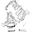
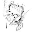
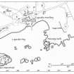
RCAHMS surveyed Dunivaig Castle in 1976 and produced a location map (1:1000), a general site plan (1:400) and phased plans at ground and first floor level (1:200). The drawings were reproduced in ink and published at reduced scales (RCAHMS 1984, figs. 268, 269B, 270). A plan of the siege works (AGD 1005/1) was not reproduced.