
White Caterthun


Archaeological Landscape(S) (Prehistoric)
Site Name White Caterthun
Classification Archaeological Landscape(S) (Prehistoric)
Canmore ID 35008
Site Number NO56NW 18
NGR NO 5400 6580
NGR Description Centred NO 5400 6580
Datum OSGB36 - NGR
Permalink http://canmore.org.uk/site/35008


- Council Angus
- Parish Menmuir
- Former Region Tayside
- Former District Angus
- Former County Angus
Field Visit (9 November 1967)
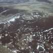
(NO 5391 6583) Hut Circle and Field System (NR)
OS 1:10,000 map, (1972).
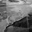
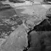
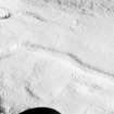
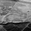
Centred at NO 539 658, on a low ridge, there are two ring-ditch houses and a probably associated field system.
The ring-ditch house at NO 5393 6582 consists of a ditch c 2.0m wide
and 0.3m deep enclosing a level platform 10.5m in diameter. There is a probable entrance causeway across the SE arc of the ditch. Twenty metres E of this house there may be another, but it is very ill-defined. There is a stone clearance heap on the west rim of the ditch.
The second ring-ditch house at NO 5404 6593 is poorly preserved but has a ditch c 3.0m wide and 0.4m deep enclosing an area 8.5m in diameter. The field system consists of small fields bounded by lynchets, fragmentary field walls and stone clearance heaps. (Name Book 1862). Ring-ditch houses surveyed at 1:2500.
Visited by OS(RL) 9 November 1967.
Note (1983)
White Caterthun 1 NO 540 659 to 537 655 NO56NW 18
On the W flank of the White Caterthun, to the E of the public road, there are three ring-ditch houses situated within an extensive field-system. Two of the houses (the larger up to 15m in diameter over a ditch 2m in breadth) are set about 20m apart on a low ridge, and the third (up to 15m in diameter over a ditch 3m in breadth) lies 120m to the NE. The surrounding field-system, which covers an area of about 20ha, is divided into both rectangular plots and narrow strips, and there are numerous small cairns. Traces of small cairns can also be identified in the improved ground to the S.
RCAHMS 1983.
(Name Book, Forfar, No. 69, p.12).
Field Visit (14 September 1989)
NO56NW 18.00 540 659 to 537 655.
NO56NW 18.01 NO 5391 6582 Ring-ditch House
NO56NW 18.02 NO 5393 6584 Ring-ditch House
NO56NW 18.03 NO 5404 6593 Ring-ditch House
NO56NW 18.04 NO 540 658 Field-system; Small Cairns
NO56NW 18.05 NO 5395 6601 Pillow Mound
These monuments are situated to either side of a shallow gully that cuts from NE to SW across gently-sloping ground some 500m SW of the White Caterthun fort (NO56NW 17). They comprise the following elements:
Visited by RCAHMS (DCC) 14 September 1989.

