| 1106723 |
RECORDING |
FIELD VISIT |
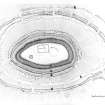
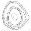
The fort that crowns the summit of the Brown Caterthun commands impressive views across Strathmore. The defences present a remarkable array of earthworks, some slight, others more substantial, and thus can be shown to reflect several periods of construction. The order in which all seven lines of earthworks were constructed, however, cannot be demonstrated without excavation, and for the purposes of this description they are lettered from the innermost outwards (A-G). The innermost (A) is defined by little more than a shallow groove defining the N side of an enclosure measuring about 30m in diameter. The innermost of the ramparts (B) has been reduced to a low stony bank enclosing an area measuring about 88m from NNW to SSE by 55m transversely. Five gaps are visible in the rampart, but it is not known how many of them are original. Set between 52m and 23m downslope from B there are two concentric lines of defences (C and D) enclosing an area measuring about 192m from N to S by 143m transversely. The inner (C) is a substantial rampart which has several lines of outer face visible and a few internal quarry-pits, while the outer (D) comprises twin ramparts reduced to little more than scarps. Nine entrances are visible in rampart C, all of them matched by gaps in the twin ramparts (D) beyond them; the latter, however, have an additional gap at H, which appears to be the remains of an entrance blocked by rampart C. Eccentrically placed between 10m and 43m beyond these ramparts there are two further lines of defence (E and F) which follow roughly parallel courses. The inner (E) is a thick rampart flanked by shallow internal quarry-pits for its entire circuit; the outer (F), is represented by a rampart with an external ditch and counterscarp bank, it too is intermittently flanked by internal quarry pits. Nine entrances through these defences are visible; most of them have worn hollows dropping down between the rampart terminals and three give the impression of an entrance passage flanked by low banks linking the two lines of defence. On the SW, at J, one of the quarry-pits behind rampart E appears to cut a hollowed track which drops down from an entrance through ramparts C and D. The seventh line of earthworks (G) contours round the spur to the SE of the fort and, where best preserved, comprises two low banks with a medial ditch. Three separate defensive schemes may be identified within the earthworks, one represented by rampart B, a second by ramparts C and D and a third by ramparts E and F. The evidence visible at J and H, however, only allows the defences of the second and third schemes to be placed in sequence. This evidence indicates that ramparts D were superceded by C, which was followed by the construction of E and F. Nonetheless there is no evidence of any robbing along rampart C, which may well have continued in use after the addition of E and F. These two outer lines of defences were almost certainly constructed at the same time, as can be seen by an examination of the dog-leg in the ramparts on the E side of the fort. The origin of this curious arrangement probably lies in a serious error in the planning and execution of the work. For the most part the outer defences follow the contour, but at K they turn abruptly upslope and cut across the SE spur of the hill; the slight earthwork G apparently continues this line along the contour. Whether G is a marking out earthwork is impossible to determine, but it appears that the builders of E and F took a short cut over the spur to shorten their perimeter, but failed to achieve the correct alignment when they met the ramparts under construction on the E. Both lines of defence make abrupt changes in direction here, but faint scars (L, M and N) possibly derived from marking out or the first stages of construction, continue their lines. The relationship of the innermost rampart (B) and the inner enclosure (A) to the rest of the defences is unknown. The poor state of preservation of rampart B, however, suggests that it was robbed to provide stone for the comparatively undisturbed rampart C. The remains of the inner enclosure (A) are similar to those identified in the White Caterthun fort (NO56NW 17) and are comparable to the slight earthworks derived from palisaded enclosures in the Border Hills. [...] |
August 1989 |