
Anstruther Wester, High Street, St Adrian's Church Hall


Church (16th Century), Inscribed Stone (16th Century)
Site Name Anstruther Wester, High Street, St Adrian's Church Hall
Classification Church (16th Century), Inscribed Stone (16th Century)
Alternative Name(s) St Nicolas' Church; Anstruther Wester Parish Church; Tolbooth Tower; Elizabeth Place
Canmore ID 34061
Site Number NO50SE 10
NGR NO 56444 03532
Datum OSGB36 - NGR
Permalink http://canmore.org.uk/site/34061


- Council Fife
- Parish Anstruther Wester
- Former Region Fife
- Former District North East Fife
- Former County Fife
NO50SE 10.00 56444 03532
NO50SE 10.01 NO 56459 03532 Churchyard
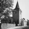
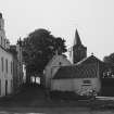
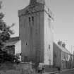
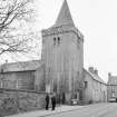
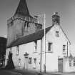
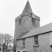
Anstruther Wester church is dedicated to St Nicolas. The tower is a fair specimen of the keep-like structures often erected in connection with Scottish churches in the 16th century. (For earlier church (pre-1177) see NO50SE 20).
D MacGibbon and T Ross 1897
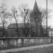
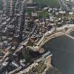
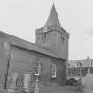
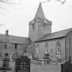
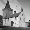
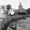
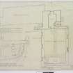
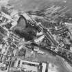
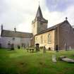
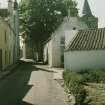
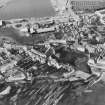
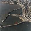
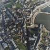
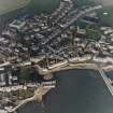
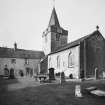
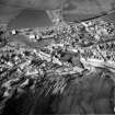
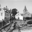
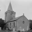
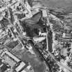
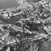
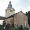
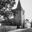
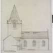
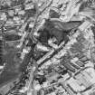
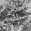
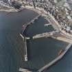
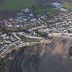
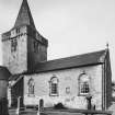
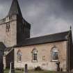
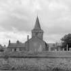
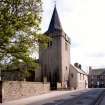
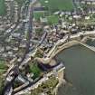
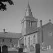
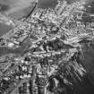
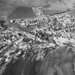
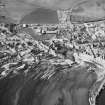
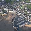
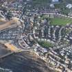
(NO 5643 0352) Anstruther Wester Parish Church stands in its graveyard beside the harbour and consists of an entirely modernised nave and a W tower surmounted with a spire. The tower is a 16th century bell tower. On the S wall of the church is a panel dated 1598. In the churchyard are several 17th century table stones and a stone coffin in which a recess is formed for the head.
RCAHMS 1933
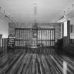
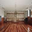
As described. The church is now used as a hall.
Visited by OS (JP) 28 May 1974
Field Visit (29 June 1927)
Parish Church.
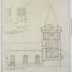
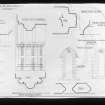
The church, which stands within its graveyard beside the harbour, consists of nave and west tower. The nave has been entirely modernised, but the tower remains a good example of a 16th-century bell-tower. It is built of rubble, harled, and contains four storeys. In each face of the bell chamber is a doublet-window with segmental outer arch and foiled head. The parapet is of ashlar and is borne on a series of projecting corbels of two members each; in places it is pierced to form an open balustrade. The spire is of timber, slated.
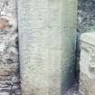
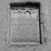
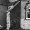
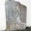
INSCRIPTIONS. On the south wall of the church, outside are two inserted panels. The upper one reads: ANNO I598 /MY HOVS IS THE/HOVS OF PRAYER. The lower has the legend: ENTER.IN.AT/YE. STRAIT.GE/T.IT.IS.YE.VYD.GET. YAT.LEDS/TO.PERDITION, and bears a representation of the two gates in the upper part.
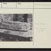
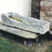
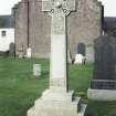
STONE COFFIN. In the churchyard, on the south side of the church, is a stone coffin measuring 6 feet 2 ½ inches by 1 foot 9 ½ inches by 1 foot; a recess is formed for the head.
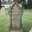
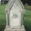
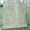
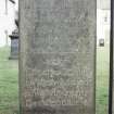
SEPULCHRAL MONUMENTS. Several 17th-century table-stones lie in the churchyard, and four of these are of some interest: The first bears the initials A.K. and the date 1667. The name is illegible, but the word "MERCHANDE " can be deciphered. The second commemorates NORMAND FAIRFVL, a former bailie who died in 1661. The third shows the names of John Oliphant, who died in 1644, and of Peter Oliphant, the date of whose decease is left uncarved. The fourth is dated 1626 and displays the usual funereal devices of skull, cross bones, and Bible. The name is illegible, out on the lower part of the stone are the initials M.I.F. and a shield charged with three papingoes or parrots, apparently for Fairfowl or Fairful.
RCAHMS 1933, visited 29 June 1927.
Photographic Survey (July 1963)
Photographic survey of buildings in Anstruther Wester, Fife, by the Ministry of Work/Scottish National Buildings in July 1963.
Excavation (7 August 2016 - 26 October 2016)
The Kilrenny, Anstruther and Cellardyke Burgh Survey was a twelve month project involving the communities of Kilrenny, Anstruther, & Cellardyke. Through a number of community engagement programmes volunteers were involved to discover and engage with their town's heritage and explore the origins and evolution of the burghs through archaeology and historic research.
Funding came from the Heritage Lottery Fund's Townscape Heritage Initiative and Historic Environment Scotland's Conservation Area Regeneration Scheme and supported by Fife Council in partnership with Fife Historic Buildings Trust.
Along with the success of the volunteers and local community involvement and engagement, what the excavations have done is to shed light on the original extent, and access to, the c.1510 church. The excavations have also shown that the building of the c.1510 church involved in-filling and capping of an earlier well. Although little can be said regarding the well, it is highly likely that it served the needs of the medieval church that we know from documentary sources existed here since at least the 12th century.
Information from Rathmell Archaeology Ltd (T Rees) 2016.
OASIS ID: rathmell1-222737

