
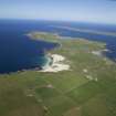
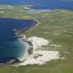
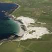
Westray, Links Of Noltland


Building(S) (Bronze Age), Floor(S) (Prehistoric), Inhumation(S) (Bronze Age), Settlement (Prehistoric), Animal Remains (Bone)(Period Unassigned), Carved Object (Neolithic)
Site Name Westray, Links Of Noltland
Classification Building(S) (Bronze Age), Floor(S) (Prehistoric), Inhumation(S) (Bronze Age), Settlement (Prehistoric), Animal Remains (Bone)(Period Unassigned), Carved Object (Neolithic)
Canmore ID 2790
Site Number HY44NW 33
NGR HY 4289 4926
Datum OSGB36 - NGR
Permalink http://canmore.org.uk/site/2790


- Council Orkney Islands
- Parish Westray
- Former Region Orkney Islands Area
- Former District Orkney
- Former County Orkney
HY44NW 33 428 493
Grooved Ware settlement. (Information from G Petrie notebook No.9, 26-9)
RCAHMS 1946; D V Clarke, R Hope and C Wickham-Jones 1977; D V Clarke 1978; D V Clarke 1979; D V Clarke 1980; D V Clarke 1981; RCAHMS 1983; D V Clarke and N Sharples 1985; C Renfrew and S Buteux 1985.
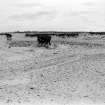
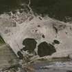
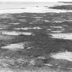
A layer of thin midden scatter is being revealed by dune retreat within the fenced-off area, at a point c.22m SW of the excavated area at the NE corner of the site. This produced 2 fragments of human bone, deposited in Tankerness House Museum (THM 1990.99). A (presumed) new exposure, designated Grobust II, was noted c.35-40m west of the track to the beach. This consists of a dense bone spread c.20m WE and 15m NS, containing cattle, sheep, deer, whale and fish. No structural remains were apparent. Three bone fragments of deer, cattle, and whale - the latter possibly being a small mattock, were deposited in Tankerness House Museum (THM 1990.109).
D Lynn and B Bell 1990.
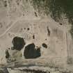
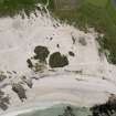
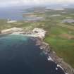
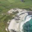
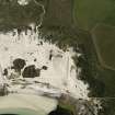
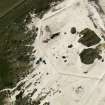
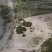
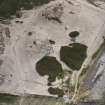
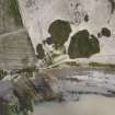
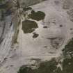
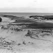
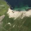
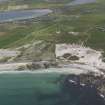
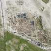
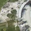
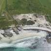
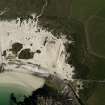
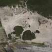
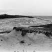
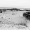
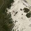
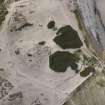
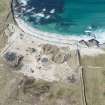
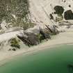
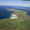
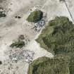
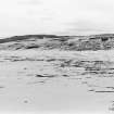
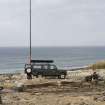
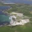
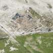
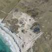
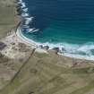
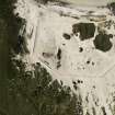
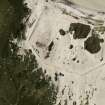
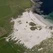
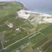
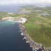
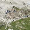
This monument comprises extensive midden deposits, field walls, houses and other structural remains dating to the Late Neolithic or Early Bronze Age, and lies in the sand dunes known as the Links of Noltland immediately south of a small bay known as Grobust.
Information from Historic Scotland, scheduling information dated October 1993.
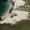
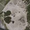
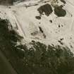
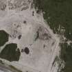
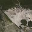
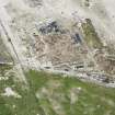
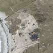
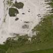
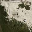
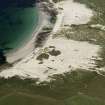
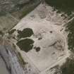
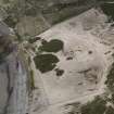
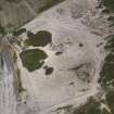
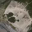
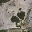
HY 42 49 area. In order to provide a basis for future management of the prehistoric settlement at Links of Noltland, Historic Scotland commissioned in October 1994 a topographic and archaeological survey of the guardianship and scheduled areas, as well as the land between these and MHWS. The surveyed area comprised approximately 8 hectares of eroding machair plain. Processes and causes of erosion, processes of stabilisation, and areas of archaeological significance were recorded, and an EDM survey was undertaken. By comparison with the results of a similar survey undertaken in 1980-81, patterns of erosion during the intervening years can be identified. Plans of both the 1980-81 and 1994 surveys have been produced at 1:500 scale.
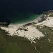
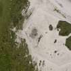
Several areas of eroding old soils, and over 15 kelp kilns, were recorded during the 1994 survey. A bed of midden was noted in an eroding dune face c 25m E of the structures excavated in 1978-81 (HY 4295 4938): the proximity of the two suggests that they are related. A spread of partially exposed remains was identified in an actively deflating area c 150m S of the excavated structures (HY 4301 4923). These remains include probable stone alignments possibly enclosing two square upright stone settings, possibly tanks or hearths, and probably comprise prehistoric buildings. No small finds were made.
Full report lodged with the NMRS. The assistance of D Fraser of English Heritage, who conducted the 1980-81 survey, and A Shepherd (representing the 1978-81 excavations) is greatfully acknowledged.
Sponsor: Historic Scotland.
A J Dunwell 1995.
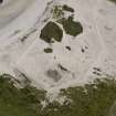
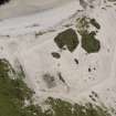
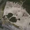
The findings of this survey indicate that there has been a substantial increase in the rate of deflation since 1987, with larger areas of the site now denuded of vegetation and eroding. The situation may have been hastened by sand quarrying in the immediate hinterland.
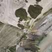
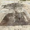
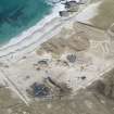
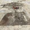
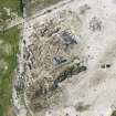
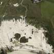
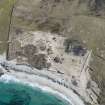
The excavation area has been reinstated and over much of the site there is little visible sign of any archaeological deposits. An arc of walling, possibly part of a circular or oval structure was noted, however. This structure is defined by an inner wall face comprising intermittent stones. It is estimated that this structure measures some 14m in diameter. It lies about 70m from the coast edge. Inside the walling were a series of uprights and a rectangular stone setting, which may be part of a hearth. There are frequent exposures of an old ground surface and there are frequent scatters of bone, shell and stone. The scheduled area is now surrounded by rabbit-proof fencing, although this does not seem to have been very effective in keeping rabbits off the site. There are frequent burrows over the entire area and in some places the fencing has been entirely covered by sand blown deposits.
Orkney Coastal Zone Assessment 1998.
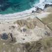
HY 428 493 A scatter of human bone was noted eroding at the Links of Noltland (NMRS HY44NW 33). At the same time, settlement remains of prehistoric date and a probable burial cairn were noted in the surrounding area. These remains were located within an unstable dune system, close to a known Late Neolithic settlement which is under Historic Scotland Guardianship. A drawn, written and photographic record was made of the archaeological remains. Limited excavation carried out in the vicinity of the human bone scatter indicated that the remains probably represented a single burial which, although ex situ, most likely had not moved far from its original resting place. The probable cairn, which was not associated with the bone spread, was found to be regularly rectangular in shape with a coursed facade on two sides and may be of Late Iron Age date. The settlement comprised at least three sub-circular buildings, together with a yard or enclosure and a probable burial mound, all of probable Late Neolithic or Early Bronze Age date. Each of the areas of archaeological interest was found to be under threat from continued deflation of the dunes in which they are located and from disturbance by rabbit burrowing.
Sponsor: Historic Scotland
H Moore and G Wilson 2000.
HY 428 493 A programme of topographic and vegetation survey, rescue recording and trial trenching was carried out in response to continued severe erosion within the PIC area at the Links of Noltland. Several hitherto unrecorded archaeological exposures were noted, one of which was subsequently planned in detail and investigated by trial trenching. In this area, an old ground surface was exposed, together with the remains of between one and three structures. These contained clay floors and are thought to be of prehistoric date.
Sponsor: Historic Scotland.
H Moore and G Wilson 2006.
HY 428 493 A programme of rescue excavation was undertaken by EASE Archaeology in February - March 2007. Three stone walled buildings were investigated by the excavation. These buildings varied in size and shape but were located in close promimity to one another and are thought to be of contemporary date. Only Structures 1 and 3 survived in good enough condition to determine their original form and possible use. The entrances of these buildings faced each other, suggesting that they were in use at the same time. Furthermore, although the number of recovered artefacts was low, similar types of artefacts were recovered from all three buildings.
Sponsor: Historic Scotland
H Moore and G Wilson 2007.
Measured Survey (August 1981)
RCAHMS surveyed the settlement at Links of Noltland in August 1981.
Note (1983)
Links of Noltland HY 428 493 HY44NW 29
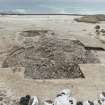
Originally recognised by the Orcadian antiquary, George Petrie, in the middle of the 19th century, this Grooved Ware site was rediscovered in 1977. Since then four seasons of excavation have been undertaken to examine the nature and size of the surviving deposits which are being exposed in a rapidly deflating machair system on the N coast of the island. This preliminary work suggests that the deposits may be spread over an area of some 3ha, but there is as yet no evidence to suggest that the remains are continuous over that area. Indeed had that once been the case, previous deflations of the machair system are likely to have eroded some material. The archaeological deposits both lie on and are covered by blown sand. The initial results suggest that the site can be conveniently subdivided into 3 areas; the west midden, the central dunes and the east midden (Grobust). Each has quite distinct structural and artefact characteristics.
The main settlement appears to have been located in the west midden. Although this is not yet confirmed, some features, including a hearth and a possible collapsed oven of Rinyo type, point towards such an interpretation. The midden itself has a compact clayey consistency and at present some 1100sq m is exposed through erosion, though this is not its full extent. Its deposition appears to have been closely· regulated in order to ensure its availability for future use. Work at the edge of this midden has shown that its deposition was preceded by a period of continuous cultivation involving the use of ards; boundaries in the form of ditches occur in the earlier phase of this cultivation. At the end of the period of midden accumulation a low wall, now partly destroyed by later cultivation on the midden, was built and adjacent to it the articulated skeletons of some eleven red deer were discovered. The sequence ends with further traces of cultivation on the midden surface.
Little is exposed in the central dunes and only one small eroding area has been excavated. A low wall with large vertical, upright slabs, regularly spaced, in one face appears to lie on top of earlier cultivation although the evidence for the latter is tenuous. Adjacent to one face of the wall there was a large bone scatter, predominantly red deer, containing both individual bones and small articulated groups. This apparent butchering debris and the wall are covered by a thin midden containing Beaker pottery, hitherto rare in the Northern Isles.
The east midden is an area of high sand-dune with a complex of well-preserved structures. The structures so far excavated have been set into holes dug into the dune, which accounts for the remarkable preservation, with walls still standing to a height of over 1.5m. Work has concentrated on a two-roomed building with the two chambers linked by a narrow passage, the roofing of which survived in situ. The N chamber was rectangular with circular cells off at each of the southern corners although in a later phase modification involved the blocking off of one cell and the construction of a dividing wall. The S chamber has a very irregular lobate plan with a large square recess opposite the entrance from the connecting passage. The whole structure was deliberately and carefully infilled although the nature of the infilling is quite different in each chamber. In plan this building is not paralleled at other Orcadian Grooved Ware sites.
Finds from the excavation have been particularly numerous, in the order of 10,000 artefacts. In general they find ready parallels in the material of Skara Brae and to a lesser extent Rinyo. However, significant differences can be seen in the material recovered from individual areas, although work on documenting these differences is only at an early stage. (D V Clarke)
RCAHMS 1983
(G Petrie Notebook, No. 9, pp. 26-9; RCAHMS 1946, ii, p. 361, No. 1081; DES 1977, 24-5; DES, 1978, 18; Clarke, Hope and Wickham-Jones 1978; DES 1980, 25; DES, 1981, 25-6).
Field Visit (1998)
An extensive settlement of the Late Neolithic-Early Bronze Age period is located beneath sand dunes around the Bay of Grobust. An examination of aerial photographs taken in 1947 indicates that some deflation was occurring at this time, with the western area being worst affected. Photographs taken in 1987 show only a slight worsening in the situation. The finding of this survey indicate that there has been a substantial increase in the rate of deflation since 1987, with larger areas of the site now denuded of vegetation and eroding. This situation may have been hastened by sand quarrying in the immediate hinterland. The site was excavated between 1978 and 1981. In one area, a sequence of stratified midden deposits and structural remains were recorded, in another a large multi-chambered structure was uncovered. Traces of field boundaries and cultivation soils were also identified. A large number of artefacts, together with quantities of environmental materials were recovered (Clarke & Sharples, 1985). The excavation area has been reinstated and over much of the site there is little visible sign of any archaeological deposits. An arc of walling, possibly part of a circular or oval structure was noted, however. This structure is defined by an inner wall face comprising intermittent stones. It is estimated that this structure measures some 14m in diameter. It lies about 70m from the coast edge. Inside the walling were a series of uprights and a rectangular stone setting, which may be part of a hearth. There are frequent exposures of an old ground surface and there are scatters of bone, shell and stone. The scheduled area is now surrounded by rabbit-proof fencing, although this does not appear to have been very effective in keeping rabbits off the site. There are frequent burrows over the entire area and in some places the fencing has been entirely covered up by wind blown sand deposits.
Moore and Wilson, 1998
Coastal Zone Assessment Survey
Project (July 2001 - August 2001)
HY 428 493 A programme of geophysical, auger and topographic survey and excavation were carried out in July and August 2001 within an area of known archaeological potential currently under threat from erosion and rabbit burrowing (see DES 2000, 69). The work investigated sites within a deflating dune system, part of which is in Guardianship. Several sites of probable prehistoric date were recorded and at least one previously unrecorded structure, a probable Bronze Age house, was discovered through geophysical survey.
A rectilinear stone structure, tentatively identified as a possible burial cairn, was fully excavated and proved to be a post-medieval structure, possibly associated with kelp working. Trial trenching was carried out on three prehistoric houses, the results indicating that at least two are well preserved. The project has pinpointed the location and condition of the surviving archaeological remains, and provided data with which to formulate a management strategy.
Sponsors: Historic Scotland, Orkney Islands Council, Orkney Archaeological Trust, University of York.
H Moore, G Wilson and J Barrett 2001
Unspecified Geophysical Survey Technique (July 2001 - August 2001)
HY 428 493 Geophysical survey.
Sponsors: Historic Scotland, Orkney Islands Council, Orkney Archaeological Trust, University of York.
H Moore, G Wilson and J Barrett 2001
Trial Trench (2006)
HY 428 493 A programme of topographic and vegetation survey, rescue recording and trial trenching was carried out in response to continued severe erosion within the PIC area at the Links of Noltland. Several hitherto unrecorded archaeological exposures were noted, one of which was subsequently planned in detail and investigated by trial trenching. In this area, an old ground surface was exposed, together with the remains of between one and three structures. These contained clay floors and are thought to be of prehistoric date.
Sponsor: Historic Scotland.
H Moore and G Wilson 2006
Excavation (February 2007 - March 2007)
HY 4280 4930 A programme of rescue excavation, sponsored by Historic Scotland, was carried out between February and March 2007 at the Links of Noltland on the NW coast of Wray. The area is subject to severe wind erosion and by rabbit overgrazing. The focus of attention was a complex of stonewalled buildings which are eroding out of sand dunes within the guardianship area. This work followed on from a rapid HS-funded site assessment undertaken in Autumn 2006. It consisted of the excavation of three closely associated sub-circular buildings, thought to be contemporary with each other and of probable Bronze Age date. One building was badly truncated; the other two were relatively well preserved and are thought to have served different purposes. Of these, the largest had an internal floor area of some 12 x 9m; the walls were up to 2m thick and faced with stone on both sides. A raised platform extended around the inner wall face and a there was a large central hearth. A series of upright stones, suggestive of radial divisions, were also present inside. An entrance at the SE was accompanied by a possible porch-type structure. The finds include chipped stone tools and
steatite vessel sherds. The second building was slightly more subrectangular in plan and was divided by upright slabs into a series of bays. The floor was paved with flagstones, covered with yellow clay. Few finds were recovered. The structures were re-covered at the close of excavation.
Archive to be deposited with RCAHMS. Report deposited with Historic Scotland and Orkney SMR.
Funder: Historic Scotland.
Excavation (September 2007 - October 2007)
HY 4280 4930 An excavation was carried out between September and October 2007 on a complex of buildings
threatened by aeolian erosion in the scheduled area at Links of Noltland. The findings indicate a settlement of probable Bronze Age date comprising of three associated circular/sub-circular buildings. They all have thick, double faced stone walls. Two of the buildings form a unit; their entrances are opposed with a paved passage set between them. The larger of these has a central hearth, is radially partitioned and appears to have served
a domestic function. The smaller building is divided into a series of bays, contains a stone-lined tank and may have been used as a byre/store/workshop. The third building is set apart and has been too severely truncated by erosion to determine its full original form.
Archive to be deposited with RCAHMS. Report to be deposited with Orkney SMR and Historic Scotland.
Funder: Historic Scotland.
Excavation (July 2008 - September 2008)
HY 428 493 A further season of assessment excavation was carried out July–September 2008. Work focussed on Area 5 which had been identified during 2007 as particularly vulnerable to wind erosion. A series of three trenches were opened to investigate probable structural remains, field systems and associated midden deposits. The results indicate the presence of at least three small buildings surrounding a larger building (Structure 8). These are thought to represent settlement remains of Neolithic date. A field wall was identified on the S side of the site. A large number of artefacts were recovered and included flint tools and working waste, stone tools, pottery (including grooved ware) and worked bone. The midden deposits contained a large quantity of animal bone and shell, together with a quantity of coprolites. A decorated stone was also recovered. The condition of the recovered materials is excellent.
Archive: RCAHMS
Funder: Historic Scotland
H Moore and G Wilson (EASE Archaeology), 2008
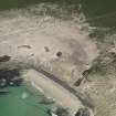
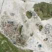
Excavation (10 June 2009 - 1 October 2009)
HY 428 493 Previous work has recorded archaeological remains eroding over a 2.5ha area at The Links of Noltland. An extended field season, 10 June–1 October 2009, saw the continued excavation of a large Neolithic house and surrounding field system and the discovery and investigation of two further Neolithic buildings. A limited programme of survey and assessment in the hinterland identified up to two further structures and two inhumation burials, all thought to be Bronze Age in date. The results of this work increases to six the number of known or suspected Neolithic buildings and to eight the number of Bronze Age buildings. While the site is at great risk from erosion, the remains are currently intact and the preservation conditions are excellent. Highlights of the 2009 season included the discovery of a small carved stone figurine. Dubbed ‘the Westray Wife’, this is the earliest representation of a human yet found in Scotland and one of very few known from the British Isles. This rare object was found amongst rubble filling in the central Neolithic building and may have been placed there at the time of its abandonment. Equally unusual and exciting was the discovery of a large number of cattle skulls which had been placed face down, horns interlinked, within the wall of an adjacent building. This structure has yet to be fully uncovered, but it is suspected that the cattle skulls continue around the entire circuit of the wall.
Archive: RCAHMS. An Interim report is planned in 2010
Funder: Historic Scotland
H Moore and G Wilson – EASE Archaeology
Project (June 2010 - July 2010)
HY 428 493 A geophysical survey was undertaken June– July 2010 across the Neolithic and Bronze Age settlements at the Links of Noltland. The survey aimed to investigate the extent and nature of archaeological features outside the Historic Scotland PIC designated area. Gradiometer and electromagnetic surveys were carried out across a 12ha area which included the site of Queena Howe, an eroding Iron Age broch, to the NW of the Links of Noltland. A georectified photographic survey was also undertaken of the coastal section N of Queena Howe. The gradiometer survey generally produced good results, although some areas were dominated by ferrous type responses caused by modern debris and disturbance. Some of the magnetic noise may also have related to past kelp burning activity. A large number of kelp pits were visible across the survey area. The magnetically quieter parts of the survey were partly due to higher ground levels and deeper deposits of sand, with the results showing the contrast of shallower overburden and less attenuated magnetic signals in other parts of the survey area. Across the mound of Queena Howe, results were dominated by a series of magnetically strong positive and negative linear anomalies, forming broadly concentric circles. These anomalies indicate the enclosing walls/ banks and ditches of the broch, while a contrastingly low magnetic response at the centre may relate to deep layers of stonework/rubble. The outer elements of the ditch system appear to form an opening slightly to the W of S, while some other trends and well defined anomalies in the data may be related to the occupation of this settlement beyond its enclosing boundaries. Substantial, magnetically strong anomalies eastwards along the coast from Queena Howe related to a prominent mound at the corner of the chain link fence enclosing the core of the scheduled area. The precise origin of the mound is unknown, but possible interpretations are either a burnt mound or debris from past industrial activity. A similarly strong and broadly circular anomaly was recorded immediately to the W of the mound. The intensity of the magnetic enhancement suggests industrial or intensive occupation activity. A series of substantial positive and negative linear anomalies, that may reflect a pattern of ancient polygonal field boundaries, were recorded to the S of the mound. These are consistent with anomalies previously detected within the HS designated area to the E. The negative anomalies represent collapsed walls and the positive responses are a result of magnetically enhanced soils that have accumulated along the wall lines. Areas of increased magnetic response
and possible it type anomalies have been identified within the enclosures formed by the boundaries. These may reflect occupation activity, although the level of response is much lower than those associated with buildings located by the previous gradiometer survey, within the HS designated
area. The results may therefore indicate the western limit of the settlement areas currently being investigated by EASE Archaeology.
A cluster of anomalies detected in the SE part of the survey area related to building remains partly visible as a platform and stone scatter. A distinct circular feature, c10–15m in diameter, with suggestions of internal divisions, was evident with a possible hearth at the centre. Other elements of archaeological interest extended to the S and could be part of a further building, again with a central hearth anomaly.
Archive: ORCA Geophysics
Funder: Historic Scotland
Electromagnetic (June 2010 - July 2010)
HY 428 493 Electromagnetic survey.
Archive: ORCA Geophysics
Funder: Historic Scotland
Magnetometry (June 2010 - July 2010)
HY 428 493 Magnetometry survey.
Archive: ORCA Geophysics
Funder: Historic Scotland
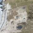
Excavation (May 2010 - September 2010)
HY 428 493 A rescue excavation was undertaken at Links of Noltland during May–September 2010. The work focused on the excavation of a Neolithic settlement and field system, both of which are severely threatened by sand erosion. A programme of assessment was also undertaken in the wider hinterland and this work recovered traces of settlement and burial remains of probable Bronze Age date. The archaeological remains are spread across some 2ha within an area of deflating sand dunes. The excavation saw the removal of substantial deposits of Neolithic midden. This material, over 1m thick in places, was extremely rich in artefacts and animal bone. More than 12,000 small finds
were recovered including quantities of elaborately decorated Grooved Ware pottery, including some near complete vessels and some with an unusual spiral motif, worked bone pins, beads and tools, flint, stone tools, pigments and decorated and painted stones. There were also concentrations of animal bone suggestive of butchery waste and several whole animal burials, including that of a red deer. In total, some 150 tons of midden were excavated. With the midden capping removed, traces of at least five stone walled structures were revealed. Of these, Structure 9, which was partly uncovered in 2009, was completely excavated. This building, 9m in diameter, was found to be sub-oval in plan with a cruciform interior. Most notably, a series of some 30 cattle skulls had been placed in the wall foundations at the time of its construction. The other buildings are clustered together c10m from Structure 9 and, at least for part of their life, were bounded by a substantial enclosure wall. The interiors of these structures were not fully excavated and it is hoped that work in 2011 will
continue in this area. Assessment of the surrounding field system found evidence for several field banks and lynchets and a possible post built structure. In the wider area, part of an eroding Bronze Age house was investigated. This was found to have been badly damaged by rabbit burrowing, although a large steatite vessel was preserved on the floor.
A series of truncated cremation deposits, together with two cists, one containing infant remains and the other containing fragments of several individuals were found nearby; previously a series of remains from this area have been radiocarbon dated to the mid-second millennium BC. In tandem with the excavations, a programme of scanning has been carried out by the Historic Scotland Laser Scanning Team and a programme of soil mapping and sampling has been undertaken by Laura McKenna (University of Stirling) as part of a PhD study. A PhD study of the faunal remains is
being carried out by Sheena Fraser (University of Edinburgh).
Archive: RCAHMS (intended) Report: Scheduled for publication
Funder: Historic Scotland
Excavation (November 2011)
HY 428 493 A rescue excavation was undertaken at Links of Noltland during May–November 2011. The work focused on the excavation of settlement and cultivation remains and a cemetery, radiocarbon dated to the mid-second millennium BC, all of which are severely threatened by sand erosion. A pair of stone walled structures thought to represent a house and ancillary building, were excavated and a third building was examined in detail. While the remains were found to have been truncated by erosion and further damaged by rabbit burrowing, sufficient survived to provide a comprehensive insight into the development of the settlement and the life of its inhabitants. Finds included steatite vessel sherds and a substantial number of stone tools, over 70 of which were recovered from the lining of a large pit. Excavation of the cemetery uncovered further cremation and inhumation burials, several of which had been truncated by erosion. Cultivation remains included areas of ard marks and field boundaries.
Archive: RCAHMS (intended)
Funder: Historic Scotland
EASE Archaeology, 2011
Excavation (February 2012 - September 2012)
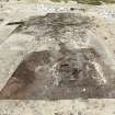
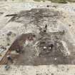
HY 4280 4530 A further large scale excavation was carried out at Links of Noltland during February – September 2012. The main focus was Structure 18, a subterranean building partially excavated by the NMS 1978–81. The building consists of two c1.1m high rooms joined by passages. Significant finds from the building included two carved stone figurines, large quantities of articulated animal bone as well as Grooved Ware pottery, flint, worked bone, bone, stone tools and decorated stones. Closing deposits in the passage between Rooms 1 and 3 were found to contain c18 cattle skulls laid on the floor, together with c6 sheep skulls.
Excavation continued on Area 5, a complex of buildings associated with an enclosure wall. Work here included the excavation of more midden deposits and two buildings, Structures 10 and 19. A carved stone ball was recovered from infill within Structure 10. Work on the Bronze Age settlement included further excavation of a structural complex (Structure 13) together with surrounding and underlying middens.
Archive: RCAHMS (intended)
Funder: Historic Scotland
Hazel Moore, EASE Archaeology
Graeme Wilson,
2012
Excavation (February 2014 - March 2014)
HY 428 493 A programme of rescue excavation was undertaken, February – March 2014, within a rapidly deflating area inland of the Links of Noltland. The focus of attention was a group of dry stone buildings, exposed by erosion, together with a sample of their surrounding landscape. Work identified a complex structural sequence of rebuilding and replacement, representing at least six buildings, consisting of houses and outbuildings. The remains date to the mid-second millennium BC. Investigations of the wider landscape identified cultivation remains, enriched soils and domestic middens. The buildings are generally well preserved, with walls standing up to 1m high. This settlement, together with two further settlement clusters located nearby and their associated cemeteries represent the most complete Bronze Age landscape yet to be investigated in Orkney.
Archive: RCAHMS
Funder: Historic Scotland
Hazel Moore and Graeme Wilson – EASE Archaeology
(Source: DES)
Excavation (March 2014 - October 2014)
HY 428 493 A programme of archaeological work was undertaken at the Links of Noltland, March – October 2014. The work included monitoring and assessment in advance of fencing works and grass planting, together with an extended season of excavation.
The watching brief led to the identification of cultivation remains and enriched soils, while the evaluation in advance of grass planting uncovered the hitherto unsuspected remains of human burials and a semi-subterranean structure of prehistoric date.
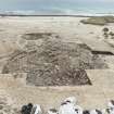
Work during the main excavation season focused on Area 5, an extensive enclosed Neolithic settlement and its surrounding hinterland. First discovered in 2007, when it became exposed as the result of sand erosion, these remains represent the most extensive of three settlements of this date yet uncovered at Links of Noltland. It consists of a series of at least seven well preserved dry stone buildings arranged in close proximity
within a finely built stone-walled enclosure, linked by paved passageways and surrounded by extensive and extremely rich midden deposits. Work in 2014 saw the excavation of four structures, together with the excavation of external areas, including domestic ‘door dumps’, industrial features, butchery middens and stockades. A large assemblage of Neolithic artefacts was recovered, including several polished stone axes and a range of worked bone objects. A human burial was also uncovered.
Archive: RCAHMS
Funder: Historic Scotland
Hazel Moore and Graeme Wilson – EASE Archaeology
(Source: DES)

