
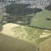
Culduthel Mains Farm


Pit(S) (Period Unassigned)
Site Name Culduthel Mains Farm
Classification Pit(S) (Period Unassigned)
Canmore ID 273704
Site Number NH64SE 359
NGR NH 662 417
Datum OSGB36 - NGR
Permalink http://canmore.org.uk/site/273704


- Council Highland
- Parish Inverness And Bona
- Former Region Highland
- Former District Inverness
- Former County Inverness-shire
Archaeological Evaluation (April 2004)
NH64SE 359 662 417
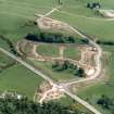
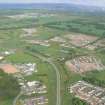
An evaluation was undertaken in April 2004 on the site of a proposed housing development. A number of linear features were recorded that are representative of cultivation and field improvement, the majority probably being of late 18th/early 19th-century date. A number of shallow pits and one large circular pit containing an abundance of charcoal were also recorded. Other than modern pottery, no finds were recovered.
Report lodged with Highland SMR and the NMRS.
Sponsor: Scotia Homes.
R Coleman 2004
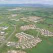
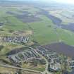
Archaeological Evaluation (May 2004)
NH 660 417 An evaluation was undertaken in May 2004 prior to housing development. A ring-cairn (NH64SE 26) assumed to be of the Clava type lies immediately NE of the site.
Thirteen trenches (2000m2) were stripped, equivalent to 5% of the development area. Only one archaeological feature was uncovered, at the southern end of the site. This was a pit, circular in plan and filled with a charcoal-rich deposit. It was apparently isolated and no datable finds were recovered from the fill.
Reports lodged with Highland SMR and the NMRS.
Sponsor: Tulloch Homes Ltd.
M Hastie 2004

