
King's Seat


Fort (Early Medieval), Hearth(S) (Early Medieval) (550)-(645), Crucible(S) (Early Medieval), Crucible(S) (Early Medieval), Mould(S) (Stone)(Early Medieval)
Site Name King's Seat
Classification Fort (Early Medieval), Hearth(S) (Early Medieval) (550)-(645), Crucible(S) (Early Medieval), Crucible(S) (Early Medieval), Mould(S) (Stone)(Early Medieval)
Alternative Name(s) King's Pass; Kingseat; 'the Fort Of The Caledonians'
Canmore ID 27172
Site Number NO04SW 19
NGR NO 0093 4303
Datum OSGB36 - NGR
Permalink http://canmore.org.uk/site/27172


- Council Perth And Kinross
- Parish Dunkeld And Dowally
- Former Region Tayside
- Former District Perth And Kinross
- Former County Perthshire
NO04SW 19 0093 4303
(Name: NO 0086 4299) Fort (NR) (Site of)
OS 6" map, Perthshire (1938)
King's Seat, Dunkeld -'The Fort of the Caledonians' - consisting of a walled inner enclosure crowning a rocky bluff and measuring axially only 115' by 70', strongly defended by natural rock-faces, precipices and four ramparts.
Sources: W J Watson 1926; RCAHMS 1963; R W Feachem 1966.
King's Seat, as described above.
Surveyed at 1:10000.
Visited by OS (RD), 20 April 1971
Field Visit (7 October 1957 - 8 October 1957)
This site was included within the RCAHMS Marginal Land Survey (1950-1962), an unpublished rescue project. Site descriptions, organised by county, are available to view online - see the searchable PDF in 'Digital Items'. These vary from short notes, to lengthy and full descriptions. Contemporary plane-table surveys and inked drawings, where available, can be viewed online in most cases - see 'Digital Images'. The original typecripts, notebooks and drawings can also be viewed in the RCAHMS search room.
Information from RCAHMS (GFG) 19 July 2013.
Reference (1963)
This site is noted in the ‘List of monuments discovered during the survey of marginal land (1956-8)’, published in Vol. 1 of the RCAHMS Inventory of Stirlingshire. The 26 monuments were listed by their name, classification, parish and county, and the list also includes an indication of whether they had been planned (P), whether they were visible only as a cropmark (C), and whether they were worthy of preservation (*).
Information from RCAHMS (GFG) 30 October 2012.
Field Visit (3 April 1989)
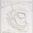
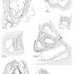
This fort is situated on the summit of King's Seat, a craggy hill on the N side of the River Tay. It has been planted with trees and the summit area is heavily overgrown with rhodedendrons; the present plan is based on the earlier published survey (by Feachem).
The defences of the fort comprise a central citadel occupying the summit of the hill and a series of ramparts taking in lower terraces. The citadel measures about 35m by 22m within what are probably the remains of a thick wall. The entrance is on the N and there appears to have been a trackway dropping down to a lower terrace on the W; the trackway and the terrace are edged by a rampart reduced to a stony bank up to 4m in thickness by 0.4m in height, its S end resting on the lip of a precipitous cliff.
Below this terrace, on the W, the approach to the fort is partially blocked by three rampart-like features, which form a flight of terraces levelled into the slope; occasional stretches of internal quarry-scoops are visible, and the leading edge of each terrace appears to have been capped with a layer of gravel and stones. Surprisingly, these terraces have only been drawn around the steeper part of the slope and do not extend across the more vulnerable ground on the N; it is possible that they are no more than landscaping features, added along with a number of carefully-constructed pathways when the policies of Dunkeld House (NO04SW 59) were laid out.
Nevertheless, there are traces of other outlying ramparts; a small terrace below the entrance on the N side of the citadel has been defended, while a lower terrace on the E has also been enclosed, its perimeter forming a substantial bank up to 5m in thickness by 1.2m in height on the N, but elsewhere reduced to much slighter proportions and overlain by a narrow stone dyke.
Visited by RCAHMS (JRS) 3 April 1989.
R W Feachem 1966.
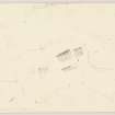
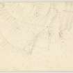
Measured Survey (February 1990)
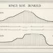
RCAHMS surveyed the fort at King’s Seat (NO04SW 19) in February 1990 at a scale of 1:500, tracing an earlier plan (by Feachem) and checking this on site. The resultant plan was redrawn in ink as part of a ‘Comparative plans of upstanding forts’ illustration and published at a scale of 1:2500 (RCAHMS 1994b, 53).
Field Visit (2008)
NO 0093 4303 At the N end of the summit (27 x 17m) is a circular enclosure 10m in diameter over a 3m wall, which incorporates the rock outcrop on E. At the lower level N, where the plan in South-east Perth – an archaeological landscape 53 shows an entrance, the E arm is offset 4m N.
Archive: RCAHMS – 2008/105, MS 5250
Dr T C Welsh, 2008
Management (5 October 2011)
Scheduled as 'King's Seat, fort... the substantial upstanding remains of a later prehistoric or early historic fort. This defended settlement survives as a series of up to four concentric ramparts and terraces, enclosing a central walled citadel on the summit of a craggy hill known as King's Seat. The fort occupies a commanding position overlooking the River Tay at approximately 150m above sea level, with excellent views to the north, south and west.'
Information from Historic Scotland, scheduling document dated 5 October 2011.
Note (6 May 2015 - 3 April 2017)
This fort is situated in the tangled woodland and undergrowth that clothes the King's Seat, a craggy hill commanding the narrow exit of the River Tay from the highlands beyond the facade formed by the Highland Boundary Fault at Dunkeld. Translated by William Watson as 'the Fort of the Caledonians', its defences appear to comprise several elements descending from an oval enclosure on the summit, and are usually conceived as a citadel with subsidiary enclosures, though there is no secure evidence to sustain this interpretation. The summit enclosure measures 35m from N to S by 22m transversely (0.06ha) within the remains of what is probably a thick wall; an entrance on the N opens onto a trackway dropping down at the rear of a second wall or rampart to a lower terrace on the W. This second rampart extends along the lip of the terace before returning back up the edge of the crag on the S to the summit to enclose an overall area measuring 55m from NE to SW by 45m transversely (2.2ha). Immediately below this rampart on the W there is a flight of what appear to be three ramparts with internal quarry ditches, though curiously they seem only to block access up the very steepest slopes, petering out on the gentler ground to the N, and it is possible that these are an antiquarian confection to enhance the presence of the fort in the designed landscape of paths and walks laid out in the policies of Dunkeld House. Nevertheless, a short length of rampart can be seen on a terrace below the summit on the N, and from the foot of the outcrops on its NE another thick bank surmounted by a narrow wall loops out to take in a lower terrace below the crags to form an annexe measuring about 90m from NNW to SSE by 40m transversely (0.35ha). The modern pathway that mounts the summit via these terraces is perhaps marking the original route into the interior.
Information from An Atlas of Hillforts of Great Britain and Ireland – 03 April 2017. Atlas of Hillforts SC3022
Excavation (7 September 2017 - 19 September 2017)
NO 0093 4303 (NO04SW 19) The scheduled monument of King’s Seat Hillfort (SM: 1598), also known as ‘The Fort of the Caledonians’, is located on the summit of King’s Seat, a key geographical feature in the landscape, located on a bend on the N side of the River Tay. Scheduled monument consent has been granted for three seasons of excavation and five trenches on the site, four of which were excavated in 2017. Trenches 2–3 were completed. Two further seasons of excavation are planned to complete the excavation of Trench 1 and 4 and start 5.
The fort’s defences consist of a central citadel occupying the summit of the hill and a series of ramparts enclosing lower terraces. The citadel measures c35 x 22m within what are probably the remains of a thick wall. The entrance is located to the N and there appears to have been a track dropping down to a lower terrace on the W. This track and the terrace are edged by a rampart reduced to a stony bank up to 4m in thickness by 0.4m in height, its S end resting on the lip of a precipitous cliff. Below this terrace, on the W, the approach to the fort is partially blocked by three rampart-like features, which form a flight of terraces levelled into the slope. The hillfort sits on exposed bedrock of the Ben Ledi Grit Formation.
Vegetation clearance of the thick rhododendron growth on the hill was carried out by a team of local volunteers in advance of survey and excavation work. A topographic survey of the site was carried out in advance of excavation to record the main features on the site. From 7–19 September 2017 a team of archaeologists from AOC Archaeology and Perth and Kinross Heritage Trust excavated four trenches on the site with a team of local volunteers.
Trench 1 (11 x 3m) investigated the series of ramparts enclosing the lower terraces. The upper rampart was fully excavated and consisted of a bank of large boulders creating a rough outer face and several postholes set back from the inner face. The second rampart was of similar construction but more slumped on the steeper slope. The third lower rampart had been reworked in more modern times as part of a landscaping on the site. Stones had been disturbed and placed along the outside edge of the lower terrace, acting as a kerb for a Victorian track running round and up the hill. A stone mould was retrieved from this trench.
Trench 2 (8 x 8m) investigated an area adjacent to the large schist glacial erratic or ‘King’s Seat’ within the summit enclosure. Topsoil or hillwash deposits were shallow here and bedrock was exposed across the whole trench. Although no features were observed within the thin hillwash deposits unstratified finds including one stone mould, several crucible fragments, several flakes of flint and modern shotgun cartridges were all recorded from this layer. Deposits of small round stones were also identified within this layer, grouped in one location near the glacial erratic and confirmed to have been introduced to the site rather than a natural occurrence. These have been tentatively interpreted as ‘slingshot’ stones.
Trench 3 (2 x 5m) was placed to investigate the summit enclosure wall immediately to the NE of the entrance. The section here revealed that that low bank visible above the ground consisted of large stones and earth with no coherent face. This feature was slumped and collapsing off the outer edge down the steep slope of the hill. Two fragments of the same stone mould were retrieved from within the bank material. The style of mould, in a ‘mirror’ form was the same as the mould found in Trench 2.
Trench 4 was opened and the topsoil removed. Within this mixed layer were large quantities of animal bone, fragments of teeth, claws and horns. Excavation was halted at the interface to the next layer; a charcoal rich horizon containing more stone and possible settings. Artefacts recovered included three stone moulds, two of ‘mirror’ form. After initial research these are similar in form to moulds identified at Garranes, Ireland and Portmahomack, Tarbat amongst others. Several small fragments of crucible were also identified; implying precious metalworking of some form had been taking place. A programme of further excavation and post-excavation analysis, including radiocarbon dating will help define the chronology and possible phasing at the site.
Archive: PKHT
Funder: HLF
Information from AOC Archaeology (Martin Cook, Andy Heald, David Strachan, Katie Roper, Sarah Malone and Cathy Mcivor), Perth and Kinross Heritage Trust, Dunkeld and Birnam Historical Society - 2018
(Source: DES, Volume 18)
OASIS ID - aocarcha1-302707
Excavation (2017 - 2019)
NO 0093 4303 King’s Seat Hillfort (SM 1598; Canmore ID: 27172), also known as 'The Fort of the Caledonians', is located on the summit of King's Seat, a key geographical feature in the landscape, located on a bend on the north side of the River Tay. The fort’s defences are comprised of a central citadel occupying the summit of the hill and a series of ramparts enclosing lower terraces. The citadel measures about 35 x 22m within what are probably the remains of a thick wall. The entrance is located to the north, and there appears to have been a track dropping down to a lower terrace on the west. This track and the terrace are edged by a rampart reduced to a stony bank up to 4m in thickness by 0.4m in height, its south end resting on the lip of a precipitous cliff. Below this terrace, on the west, the approach to the fort is partially blocked by three rampart-like features, which form a flight of terraces levelled into the slope. King’s Seat Hillfort sits on exposed bedrock of the Ben Ledi Grit Formation, Metasandstone.
Scheduled monument consent was granted in principle for three seasons of excavation and seven trenches on the site, three of which were excavated in 2017 and two in 2018. Trench 2-3 were completed in 2017. Trench 1 and 5 were completed in 2018. In the final season of excavation in 2019 the team completed the excavation of Trench 4, 6 and 7.
From 2-4 September 2019, three trenches were opened at King’s Seat. Trench 4 was extended to 6 x 11m. A smaller section of this had been opened and the topsoil removed in 2017. Within this mixed layer were large quantities of animal bone, fragments of teeth, claws and horns in addition to crucible fragments and other evidence of metal-working. In 2018 this upper thick deposit of undifferentiated topsoil was removed across the trench and 100% sieved. It contained many more crucible fragments, stone ingot moulds, a glass bead, vessel glass and substantial deposits of animal bone, horn and teeth. A small stone platform, which measured c.3 x 1.5m, was identified and contained in situ burning remains on its surface. A stone-kerbed hearth setting was also identified within the concentration of ash and animal bone and this could relate to a larger structure in this area. A radiocarbon date of a sample from the ash- and animal bone-rich material at the base of the hearth returned a date of 550-645 cal AD.
Excavation in 2019 continued to reveal that the hearth measured 2 x 0.9m, showing evidence for at least two phases of construction and rebuild. It was recorded within the remains of a probable rectangular structure that measured at least 6m wide, an area defined by a line of stone settings on the west side and a spread of material outside of this believed to comprise a degraded turf bank. To the east side, the remains of later spade dug rig and furrow had truncated the other edge of the structure. The cultivation most likely relates to a later small-scale market garden or cultivation plot taking advantage of the south-facing slope and the well-drained, fertile soil.
Trench 6 was opened in 2019. During removal of the mixed topsoil layer, fragments of E-ware ceramic, glass beads and glass gaming pieces or inserts were recovered. At around 0.4m deep across the trench an occupation horizon was identified. This was characterised by spreads of stone and charcoal-rich deposits with metal-working waste such as slag, clay moulds and crucible fragments. Two separate stone hearths were identified within the trench, presumably within structures or buildings, although the extent of these was hard to define within the limited area of the trench. The lack of substantial animal bone and presence of metal-working debris suggests that the middle terrace on the hill had once formed a workshop or craft activity area. Work in 2017 had investigated the banks that enclose this terrace – and material from a posthole at the back of the inner upper bank enclosing the mid-terrace provided a radiocarbon date of 435-642 cal AD. This indicates that construction may have taken place in the Early Historic period.
Trench 7 measured 2 x 5m and was placed to investigate the lower D-shaped enclosure wall on the east of the site. The section here revealed that a substantial bank, visible above the ground, that consisted of large boulders and earth with a large rough kerb along the inner and outer edges. On the interior of the bank a flat terrace contained an occupation deposit that yielded sherds of ceramic, metal objects and metal-working waste. A discrete dump of metal-working waste containing a large amount of slag and a hearth base was identified deposited against the interior of the bank.
The artefacts recovered from across the site imply that there has been a significant and extensive phase of Early Historic activity at the King’s Seat. Spindle whorls, glass beads, vessel glass, crucible fragments, clay and stone moulds and iron objects including blades all imply craft and domestic activities were taking place on this site. Many of the objects in the finds assemblage would not be out of place on other high-status enclosed sites dating to the early historic period. Initial radiocarbon dating reinforces this interpretation and also suggests an Early Historic origin for the construction of the enclosure on this site. A programme of further excavation and post-excavation analysis is planned, including further radiocarbon dating, which will help define the chronology, phasing and activity at the site.
Archive: PKHT
Funder: Heritage Lottery Fund, The Gannochy Trust, and the Griffin and Calliachar Community Fund
Cathy MacIver, Martin Cook, Andy Heald, David Strachan, Yvonne Robertson ̶ AOC Archaeology Group, Perth and Kinross Heritage Trust, Dunkeld and Birnam Historical Society
(Source: DES Vol 20)
Excavation (4 September 2018 - 15 September 2018)
NO 0093 4303 The scheduled monument of King’s Seat Hillfort (SM1598), also known as ‘The Fort of the Caledonians’, is located on the summit of King’s Seat, a key geographical feature in the landscape, located on a bend on the N side of the River Tay. The fort’s defences consist of a central citadel occupying the summit of the hill and a series of ramparts enclosing lower terraces. The citadel measures c35 x 22m within what are probably the remains of a thick wall. The entrance is located to the N and there appears to have been a track dropping down to a lower terrace on the W. This track and the terrace are edged by a rampart reduced to a stony bank up to 4m in thickness by 0.4m in height, its S end resting on the lip of a precipitous cliff. Below this terrace, on the W, the approach to the fort is partially blocked by three rampart-like features, which form a flight of terraces levelled into the slope. King’s Seat Hillfort sits on exposed bedrock of the Ben Ledi Grit Formation.
Scheduled monument consent has been granted for three seasons of excavation and seven trenches on the site, three of which were excavated in 2017. Trenches 2–3 were completed in 2017. Trenches 1 and 5 were completed in 2018. Trench 4 was continued from 2017. One further season of excavation is planned to complete the excavation of Trench 4 and undertake 6 and 7. Three trenches were opened this season, 4–15 September 2018. Trench 1 (20 x 3m) investigated the lower two ramparts enclosing the lower terraces. The upper rampart was fully
excavated in 2017 and consisted of a bank of large boulders creating a rough outer face and several postholes set back from the inner face. In 2018 the second rampart was of similar construction but more slumped on the steeper slope and overlay remains of stone wall facing, no timber component was evident. The third lower rampart was excavated and had clearly been reworked and perhaps even created in more modern times as part of track construction and landscaping on the site in the Victorian period. Stones had been disturbed and placed along the outside edge of the lower terrace, acting as a kerb for a Victorian track running round and up the hill. Trench 4 was extended to 6 x 11m. A smaller section of this had been opened and the topsoil removed in 2017.
Within this mixed layer were large quantities of animal bone, fragments of teeth, claws and horns in addition to crucible fragments and other evidence of metal working. In 2018 this upper thick deposit of undifferentiated topsoil was removed across the trench and 100% sieved. It was found to contain many more crucible fragments, stone ingot moulds, a glass bead, vessel glass and substantial deposits of animal bone, horn and teeth. A small stone platform, c3m x 1.5m, was identified which had in situ burning remains on its surface. A stone kerbed hearth setting was also identified within the concentration of ash and animal bone and could relate to a larger structure in this area. Excavation here will continue in 2019 to reveal the layer that the hearth sits on and any other structural components of this feature.
Stone kerbed hearth setting in the upper citadel, King’s Seat Trench 5, 2 x 5m, was placed to investigate the summit enclosure wall on the S of the site. The section here revealed that a low bank visible above the ground consisted of large stones and earth with a rough kerb on the inner edge. The outer edge was not identified and appears to have collapsed down the steep slope of the hill. A stone weight with a hole
bored through the middle was identified, incorporated into the wall core.
Trench 6 was opened and the topsoil removed. Within this mixed layer were fragments of E-ware ceramic, glass beads and glass gaming pieces or inserts. Excavation was halted at the interface to the next layer c0.35m deep: a stony spread. This trench will be reopened and completed in 2019.
The artefacts recovered imply that a period of activity in the early historic period can be identified on site. Spindle whorls, glass beads, vessel glass, crucible fragments, clay and stone moulds and iron objects including blades all imply craft activities were taking place. Many of the objects in the finds assemblage would not be out of place on other high status enclosed sites dating to the Early Historic Period.
A programme of further excavation and post-excavation analysis, including radiocarbon dating will help define the chronology, phasing and activity at the site.
Archive: PKHT
Funder: Heritage Lottery Fund, The Gannochy Trust, and the
Griffin and Calliachar Community Fund
AOC Archaeology Group, Perth and Kinross Heritage Trust, Dunkeld and Birnam Historical Society
(Source: DES, Volume 19)
Information from OASIS ID: aocarcha1-336290 (C. MacIver, M. Cook, A. Heald, Y. Robertson, D. McLaren, D. Strachan, G. Lindsay) December 2018
Excavation (2 September 2019 - 14 September 2019)
King’s Seat Hillfort (NGR: NO 0093 4303; NMRS: NO04SW19; PKHER: MPK5444; Scheduled Monument: 1598), also known as 'The Fort of the Caledonians', is located on the summit of King's Seat, a key geographical feature in the landscape, located on a bend on the north side of the River Tay. The forts defences are comprised of a central citadel occupying the summit of the hill and a series of ramparts enclosing lower terraces. The citadel measures about 35m by 22m within what are probably the remains of a thick wall. The entrance is located to the north and there appears to have been a track dropping down to a lower terrace on the west. This track and the terrace are edged by a
rampart reduced to a stony bank up to 4m in thickness by 0.4m in height, its south end resting on the lip of a precipitous cliff. Below this terrace, on the west, the approach to the fort is partially blocked by three rampart-like features, which form a flight of terraces levelled into the slope. King’s Seat Hillfort sits on exposed bedrock of the Ben Ledi Grit Formation, Metasandstone.
Scheduled monument consent was granted in principle for three seasons of excavation and seven trenches on the site, three of which were excavated in 2017 and two in 2018.
Trench 2-3 were completed in 2017. Trench 1 and 5 were completed in 2018. In the final season of excavation in 2019 the team completed the excavation of Trench 4, 6 and 7.
From September 2nd to 14th, 2019, three trenches were opened at Kings Seat.
Trench 4 was extended to 6m by 11m. A smaller section of this had been opened and the topsoil removed in 2017. Within this mixed layer were large quantities of animal bone, fragments of teeth, claws and horns in addition to crucible fragments and other evidence of metal working. In 2018 this upper thick deposit of undifferentiated topsoil was
removed across the trench and 100% sieved. It was found to contain many more crucible fragments, stone ingot moulds, a glass bead, vessel glass and substantial deposits of animal bone, horn and teeth. A small stone platform was identified which measured c. 3m by 1.5m and had in situ burning remains on its surface. A stone kerbed hearth setting
was also identified within the concentration of ash and animal bone and could relate to a larger structure in this area. A radiocarbon date confirmed the ash and animal bone rich material at the base of the hearth dated to 550-645 cal AD Excavation in 2019
continued to reveal the hearth measured 2m by 0.9m and confirmed at least two phases of construction and rebuild. It was recorded within remains of a probable rectangular structure at least 6m wide defined by a line of stone settings on the west and a spread of material outside this that might relate to a degraded turf bank. To the east remains of later spade dug rig and furrow had truncated the other edge of the structure. The cultivation most likely relates to a later small-scale market garden or cultivation plot taking advantage of the south facing slope and the well drained, fertile soil.
Trench 6 was opened and the topsoil removed. Within this mixed rooty layer were fragments of E-ware ceramic, glass beads and glass gaming pieces or inserts. At around 0.4m deep across the trench an occupation horizon was identified characterised by spreads of stone and charcoal rich deposits with metal-working waste such as slag, clay moulds and crucible fragments. Two separate stone hearths were identified within the trench, presumably within structures or buildings, although the extent of these was hard to define within the extent of the trench. The lack of substantial animal bone and presence of metal-working debris suggests that the middle terrace on the hill has been a workshop or craft activity area. Work in 2017 investigated the banks that enclose this terrace and material from a posthole at the back of the inner upper bank enclosing the mid-terrace dated to 435-642 cal AD indicating construction in the early historic period rather than reuse of a pre-existing feature.
Trench 7 was 2m by 5m and placed to investigate the lower D-shaped enclosure wall on the east of the site. The section here revealed that a substantial bank visible above the ground consisted of large boulders and earth with a large rough kerb on the inner and outer edge. On the interior of the bank a flat terrace contained an occupation deposit with sherds of e-ware ceramic, metal objects and metal working waste. A discrete dump of metal working waste containing a large amount of slag and hearth base was identified deposited against the interior of the bank. The artefacts recovered from across the site imply that there has been a significant and extensive phase of early historic activity at the King’s Seat. Spindle whorls, glass beads, vessel glass, crucible fragments, clay and stone moulds and iron objects including blades all imply craft and domestic activities were taking place on this site. Many of the objects in the finds assemblage would not be out of place on other high status enclosed sites dating to the early historic period. Initial radiocarbon dates reinforce this interpretation and suggest an early historic origin for the construction of the enclosure on this site. A programme of further excavation and post-excavation analysis, including further radiocarbon dating will help define the chronology, phasing and activity at the site.
Information from aocarcha1-377506 (C MacIver) 2019

