
Pricing Change
New pricing for orders of material from this site will come into place shortly. Charges for supply of digital images, digitisation on demand, prints and licensing will be altered.
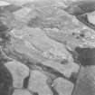
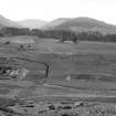
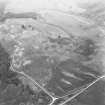
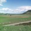
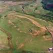
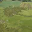
Fendoch


Roman Fort (Roman)
Site Name Fendoch
Classification Roman Fort (Roman)
Alternative Name(s) Raenfhandoch; Tom-an-die; Fendoch Roman Fort; Fendoch Fort
Canmore ID 26132
Site Number NN92NW 2
NGR NN 9196 2830
NGR Description Centred on NN 9196 2830
Datum OSGB36 - NGR
Permalink http://canmore.org.uk/site/26132


- Council Perth And Kinross
- Parish Fowlis Wester
- Former Region Tayside
- Former District Perth And Kinross
- Former County Perthshire
NN92NW 2 centred 9196 2830.
(NN 9196 2830 Fendoch Roman Fort (R) (Site of).
OS 6" map (1958)
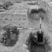
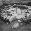
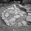
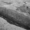
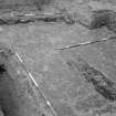
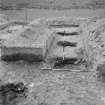
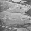
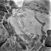
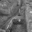
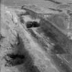
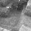
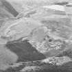
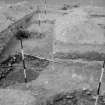
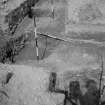
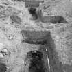
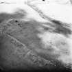
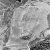
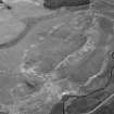
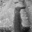
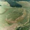
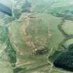
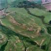
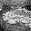
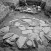
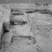
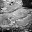
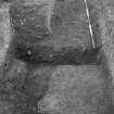
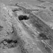
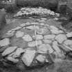
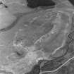
Roman fort excavated 1936-8 and dated AD 80-90. The defences consisted of a turf rampart and a single ditch, with additional ditch on the E.
An annexe was first observed in 1937 when a rampart, ditch and upcast mound outside the ditch were observed 215ft behind the east side of the fort. Two hundred feet south of the fort-rampart the ditch is interrupted by a causeway 12ft wide. The east defences continue towards the edge of the natural terrace above the Fendoch Burn. Before reaching the brink they curve westwards but are almost immediately lost.
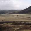
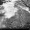
There are no further surface indications.
I A Richmond et al 1939
The faint outline of part of the NE rampart of the annexe is all that is evident on the ground.
Surveyed at 1:2500.
Visited by OS (RD) 21 December 1966
Contained within the roman fort are the remains of a later farmstead which had been abandoned by the 1st edition of the OS 6-inch map (Perthshire 1867, sheet lxxxiv). see NN92NW 42.
Information from RCAHMS (AKK) 28 October 1998.
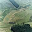
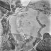
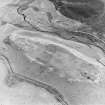
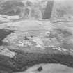
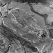
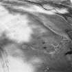
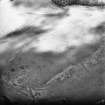
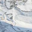
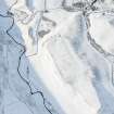
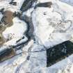
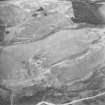
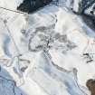
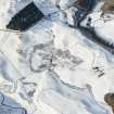
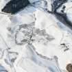
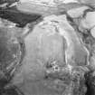
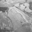
NN 919 283 Geophysical survey revealed a clear image of the Roman fort ditches to supplement the view of the interior revealed by excavations in the 1930s (PSAS 1939, 110-54). It has a double ditch with so-called 'parrot beak' entrance breaks at each of the four gates. The site measures 187m E-W by 109m over the inner ditch: an area of c 2.03ha (5 acres).
The excavations raised the possibility of an annexe attached to the W end of the fort's southern side, but made no detailed study. The survey shows the feature clearly, although its SW corner has been eroded away by the Fendoch Burn. It has a single ditch with just one entrance in the E side. It measures c 81m E-W by 86m:
an area of 0.69ha (1.7 acres). An 11m diameter ring-ditch was found inside the annexe, which may represent a native roundhouse. To the E of the annexe is a second single-ditched rectilinear feature. This, too, is attached to the fort ditch system and may also connect to the annexe ditch. It is less regular in form but measures, on average, 73m E-W by 79m.
Some 45m to the SW of the fort, a high resistance feature, c 16m E-W by 27m, was detected in an area of damp ground which probably hides a spring. This consists of a square feature attached to an oval or apsidal structure. There is no proof that the structure is Roman, or even man-made, but the size and form might suggest a bath building.
Sponsors: Roman Gask Project, Roman Research Trust.
D J Woolliscroft 2004

